MyTopo
Glen Rock Pennsylvania US Topo Map
Couldn't load pickup availability
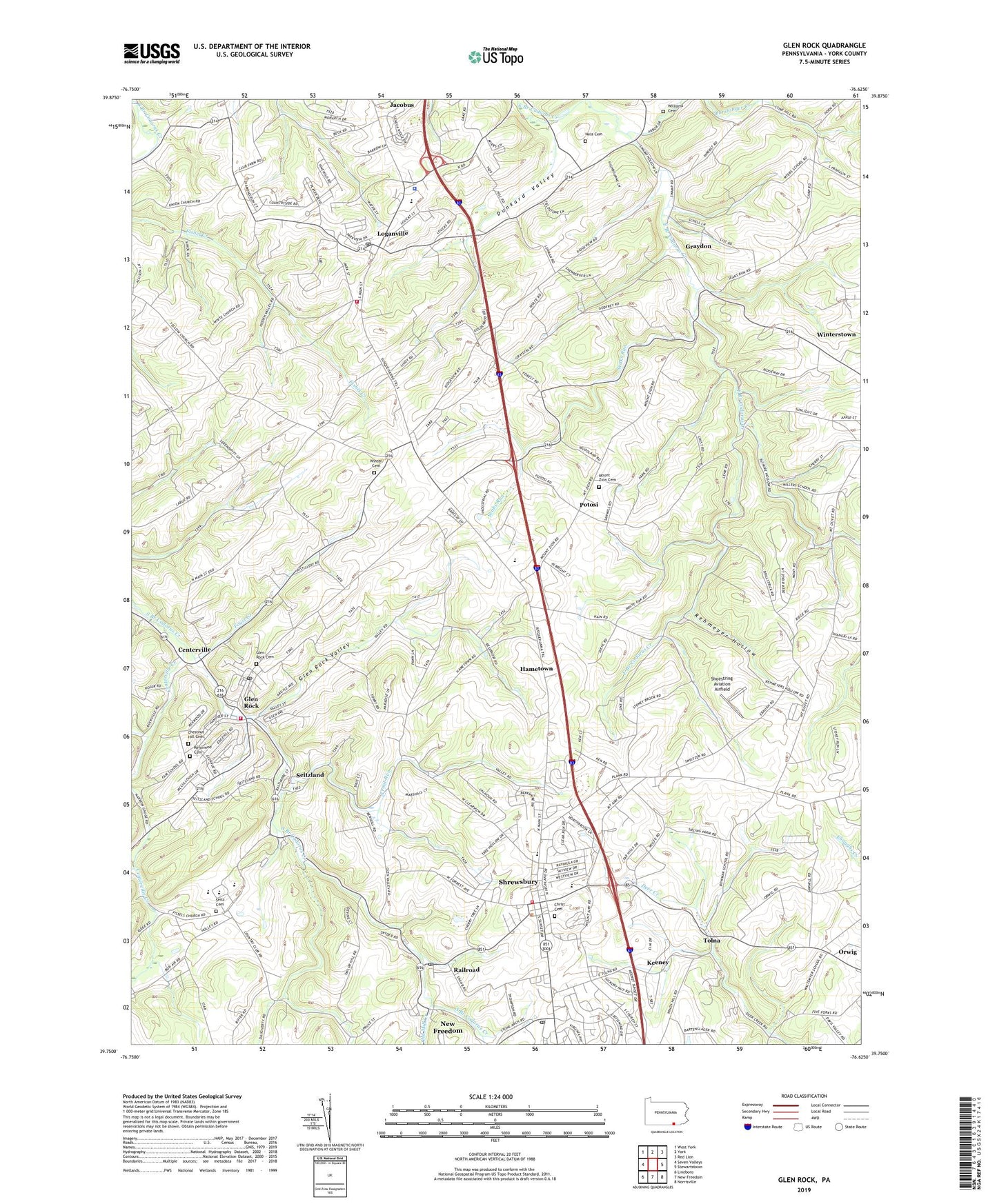
2023 topographic map quadrangle Glen Rock in the state of Pennsylvania. Scale: 1:24000. Based on the newly updated USGS 7.5' US Topo map series, this map is in the following counties: York. The map contains contour data, water features, and other items you are used to seeing on USGS maps, but also has updated roads and other features. This is the next generation of topographic maps. Printed on high-quality waterproof paper with UV fade-resistant inks.
Quads adjacent to this one:
West: Seven Valleys
Northwest: West York
North: York
Northeast: Red Lion
East: Stewartstown
Southeast: Norrisville
South: New Freedom
Southwest: Lineboro
This map covers the same area as the classic USGS quad with code o39076g6.
Contains the following named places: Anstine, Arthur Hufnagel Public Library of Glen Rock, Barshinger Creek, Bon Air Golf Course, Borough of Glen Rock, Borough of Loganville, Borough of Railroad, Borough of Shrewsbury, Bupps Union Church, Caslow School, Centerville, Centerville Creek, Chestnut Hill Cemetery, Christ Evangelical Lutheran Cemetery, Codorus Church, Dunkard Valley, Fissels Church, Foust Creek, Friedensaals Church, Glen Rock, Glen Rock Ambulance, Glen Rock Hose and Ladder Company Station 59, Glen Rock Post Office, Glen Rock Union Cemetery, Glen Rock Valley, Graydon, Hametown, Hametown Church, Hartman School, Hildebrand School, Hungerford, Keeney, Krout School, Loganville, Loganville Post Office, Loganville Volunteer Fire Company Station 63, Miller School, Mount Airy School, Mount Olivet Church, Mount Zion Cemetery, Ness Cemetery, Neutzel Farms, New Hope United Church of Christ Cemetery, Old Mill Creek, Orwig, Pennsylvania State Police Troop H York Station, Pierceville Run, Potosi, Railroad, Railroad Post Office, Railroad Run, Reformed Cemetery, Rehmeyer Hollow, Saddlers Church, Saint Peters Church, Schesslers School, Seaks Run, Seitz School, Seitzland, Seven Valleys Church, Sheffer, Shoestring Aviation Airfield, Shrewsbury, Shrewsbury Post Office, Shrewsbury Station, Shrewsbury Volunteer Fire Company Station 61, Shusters School, Southern York County Forest Fire Crew, Southern York County Library, Susquehannock School, Tolna, Tolna P O, Township of Shrewsbury, Township of Springfield, Trout Run, Turnpike Station, Williams Cemetery, Wilson Farms, Winter Cemetery, ZIP Codes: 17355, 17361