MyTopo
York Pennsylvania US Topo Map
Couldn't load pickup availability
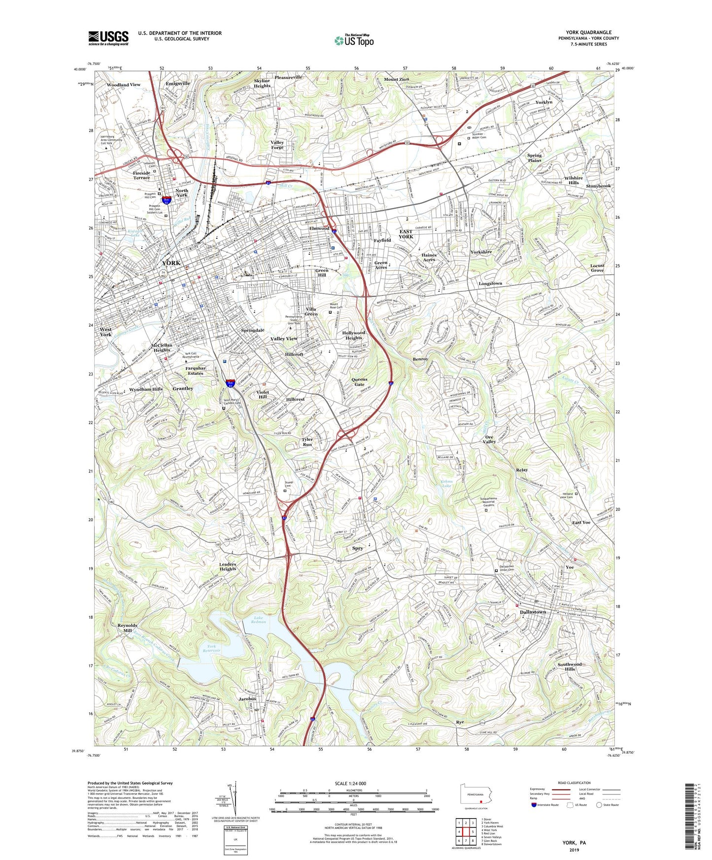
2023 topographic map quadrangle York in the state of Pennsylvania. Scale: 1:24000. Based on the newly updated USGS 7.5' US Topo map series, this map is in the following counties: York. The map contains contour data, water features, and other items you are used to seeing on USGS maps, but also has updated roads and other features. This is the next generation of topographic maps. Printed on high-quality waterproof paper with UV fade-resistant inks.
Quads adjacent to this one:
West: West York
Northwest: Dover
North: York Haven
Northeast: Columbia West
East: Red Lion
Southeast: Stewartstown
South: Glen Rock
Southwest: Seven Valleys
This map covers the same area as the classic USGS quad with code o39076h6.
Contains the following named places: A Fergusen Elementary School, A Goode Elementary School, A H Martin Elementary School, Albemarle Park, Allen Field, Amleyn Gardens, Appleton, Aries Park, Arlington Park, Avondale, Bantz Park, Barwood, Bellview Acres, Benroy, Beverly Hills, Borough of Dallastown, Borough of Jacobus, Borough of North York, Borough of Yoe, Brook Hill, Brook Hill South, Canterbury, Carol Heights, Central Senior High School, Central York Middle School, Chapel View, Chestnut Hill, City of York, Clearview Heights, Codorus Mills Station, Country Club of York, Crestlyn Court, Crestview Terrace, Dallas Acres, Dallastown, Dallastown Area Middle School, Dallastown Elementary School, Dallastown Union Cemetery, Dalvue, Davis Elementary School, Denton Terrace, East Branch Codorus Creek, East Yoe, East York, East York Census Designated Place, East York Elementary School, Elmwood, Fair Acres, Farquhar Estates, Farquhar Park, Fayfield, Ferguson Elementary School, Fireside Terrace, Fox Run, Franklin Elementary School, Golden, Grace E Loucks Elementary School, Grandview Heights, Grantley, Grantley Census Designated Place, Grantley Elementary School, Grantley Station, Grantly Hills, Green Acres, Green Hill, Gwendale, Haines Acres, Haines Acres Shopping Center, Hannah Penn Middle School, Heiland View Cemetery, Herman Heights, Hiestand School, Hillcrest, Hillcroft, Hill-n-Dale, Hollywood Heights, Homeland Gardens, Idywyld, Imperial Run, Inners Creek, J Denver Elementary School, Jackson Elementary School, Jacobus, Kalreda Woods, Kehm Run Dam, Kehms Lake, Kelsey Landing Strip, Kiwanis Lake, Lake Redman, Lake Williams, Leaders Heights, Leaders Heights Elementary School, Leafydale Terrace, Lebanon Cemetery, Lightners Elementary School, Lightners Tract, Lincoln Elementary School, Locust Grove, Longstown, Longview Heights, Madison School, Manifold Manor, Marborough West, McClellan Heights, McDonald Heights, McKinley Elementary School, Memorial Park Shopping Center, Mill Creek, Mount Rose Cemetery, Mount Rose Center Elementary School, Mount Rose Elementary School, Mount Rose Junior High School, New Fairview Church Cemetery, Nixon County Park, North Codorus, North Gate Shopping Center, North Hills, North Hills Elementary School, North York, Nurse Nursery School, Oak Manor, Oakridge, Ore Valley, Ore Valley Elementary School, Park Village, Penn Common, Penn Oaks, Pennsylvania State University - York Campus, Pleasureville, Pleasureville Elementary School, Prospect Hill Cemetery, Prospect Hill Cemetery Soldiers' Lot, Queens Gate Census Designated Place, Queensgate Shopping Center, Randolph Park, Relay, Reynolds Mill, Ridgefield, Robin Heights, Rolling Acres Pitch and Putt Golf Course, Roosevelt Elementary School, Rosemount, Rye, Saint Joseph School, Saint Mary's - Saint Patrick's Cemetery, Seven Acres, Skyline Heights, South Ridge Estates, South View Acres, South Wood Hills, Southwood Hills, Spring Garden Memorial Park, Spring Plains, Springdale, Springetts Manor-Yorklyn Census Designated Place, Springettsbury Elementary School, Springfield Township School Number 1, Spry, Spry Census Designated Place, Starview Heights, Stonewood Farms, Stony Brook Elementary School, Stonybrook, Stonybrook Census Designated Place, Stonybrook Heights, Stonybrook-Wilshire Census Designated Place, Strathcona Hills, Strickler - Miller Cemetery, Sunset Terrace, Susquehanna Heights, Susquehanna Memorial Gardens, Sylvania Heights, Teachers Driving School, The Colonial Shopping Center, Tilden, Township of Spring Garden, Township of Springettsbury, Township of York, Tracktowne Station, Tri-Hill, Tyler Run Census Designated Place, Tyler Run-Queens Gate Census Designated Place, UPMC Pinnacle Memorial, Valley Forge, Valley View, Valley View Census Designated Place, Valley View Elementary School, Villa Green, Village Green Shopping Center, Violet Hill, Violet Hill School, Waterford, WellSpan York Hospital, White Oak Park, William Penn Senior High School, Williams Dam, Willis Park, Willis Run, Wilshire Hills, Wilson Elementary School, Windsor Park, WNOW-AM (York), Woodland View, Woodstream, WQXA-FM (York), WSBA-AM (York), WSBA-TV (York), WVYC-FM (York), Wyndham Hills, Yoe, York, York Armory, York Catholic High School, York College of Pennsylvania, York Country Day School, York County, York County Hospital and Home, York County Shopping Center, York Elementary School, York Mall, York Outlet Mall, York Suburban Middle School, York Suburban Senior High School, York Township Elementary School, York Water Company Dam, Yorklyn, Yorklyn Census Designated Place, Yorkshire, Yorkshire Elementary School, Yorktown Homes, ZIP Codes: 17313, 17401, 17402, 17403, 17407