MyTopo
Lineboro Maryland US Topo Map
Couldn't load pickup availability
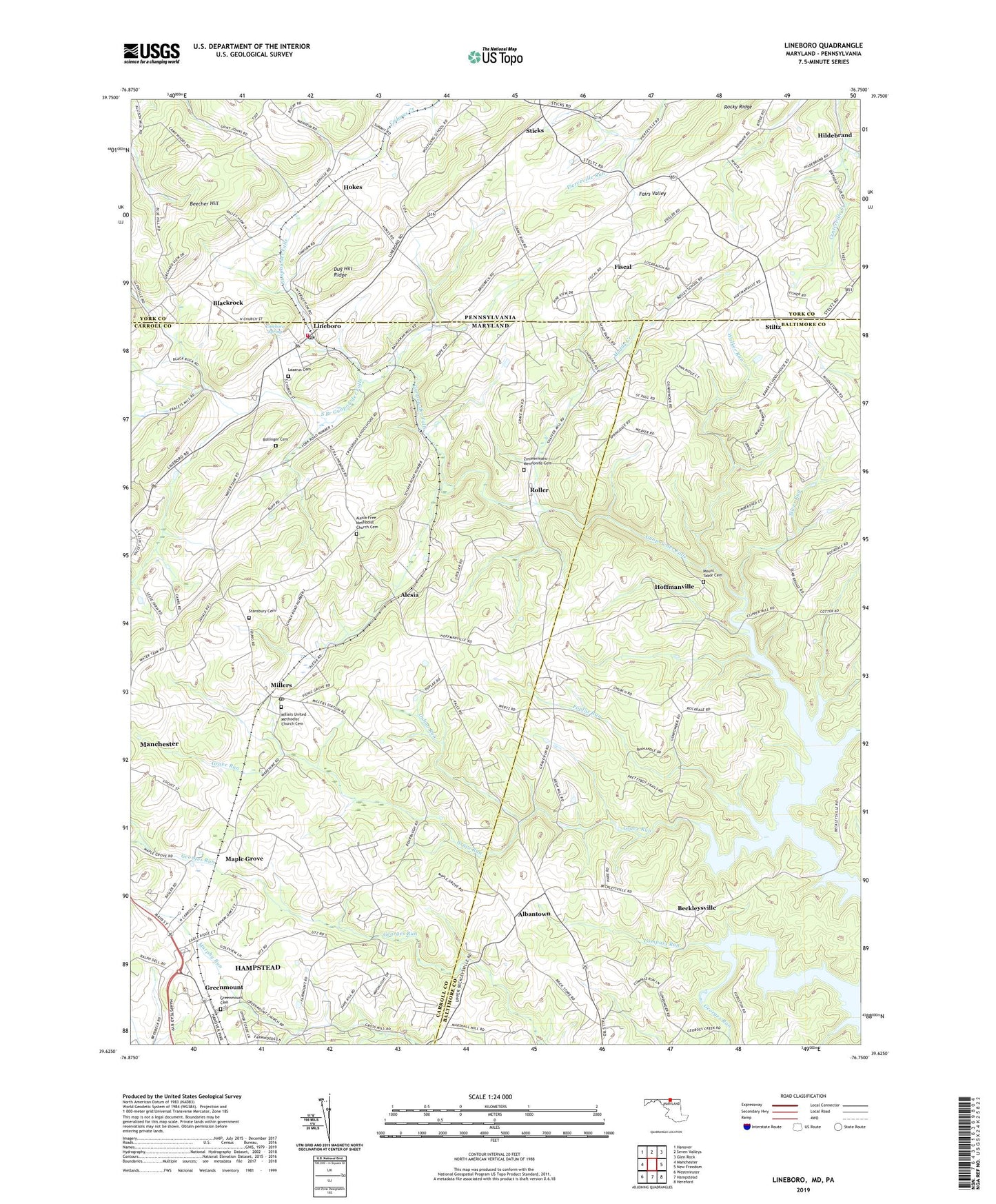
2023 topographic map quadrangle Lineboro in the states of Maryland, Pennsylvania. Scale: 1:24000. Based on the newly updated USGS 7.5' US Topo map series, this map is in the following counties: Carroll, Baltimore, York. The map contains contour data, water features, and other items you are used to seeing on USGS maps, but also has updated roads and other features. This is the next generation of topographic maps. Printed on high-quality waterproof paper with UV fade-resistant inks.
Quads adjacent to this one:
West: Manchester
Northwest: Hanover
North: Seven Valleys
Northeast: Glen Rock
East: New Freedom
Southeast: Hereford
South: Hampstead
Southwest: Westminster
Contains the following named places: Abraham Church, Albantown, Alesia, Alesia Free Methodist Church Cemetery, Alesia Heights, Baughman Mill, Beckleysville, Beecher Hill, Bethlehem Church, Blackrock, Blackrock Church, Blackrock School, Bollinger Cemetery, Boones Meadows, Breezy Hill Estates, Brothers Delight, Carroll County Fire Department Station 7 Lineboro Volunteer Fire Department, Compass Run, Donney Brook Farms, Dykes Creek, Eberseld Mill, Fairmount Church, Fairmount North, Fairs Valley, Fiscal, Forest Knoll, Foreston Ridge Estates, Free Church, Galloping Goose Vineyard, Georges Run, Grave Run, Grave Run Church, Grave Run Mills, Greenmount, Greenmount Cemetery, Greenmount United Brethren in Christ Church, Greenmount United Methodist Church, Gross Mill Estates, Gunpowder Acres, Gunpowder Ridge, Hampstead North Business Center, Happy Valley, Hildebrand, Hi-View Estates, Hoffmanville, Hokes, Hokes School, Hollinsland, Hunt Ridge, Indian Run, Intersection, Kings Tree Farm, Klein Estates, Krohs Mill Post Office, Lazarus Cemetery, Lazarus Church, Leatherwood, Lincoln Manor, Lineboro, Lineboro Post Office, Lineboro Spring, Log Schoolhouse Farms, Maple Grove, Mason Dixon Estates, Middletown Downs, Middletown Estates, Mikules Manor, Mill Stream Hills, Miller United Brethren of Christ Church, Millers, Millers Post Office, Millers School, Millers United Methodist Church, Millers United Methodist Church Cemetery, Millwood, Mount Tabor Cemetery, Mount Tabor Church, Muddy Creek, North Carroll Community Pond, North Carroll Farms, North Carroll Library, North Carroll Middle School, North Carroll Plaza Shopping Center, Oak Mont Green Golf Course, Peaceful Valley, Poplar Run, Prettyboy Hunt Club, Prettyboy Reservoir, Prettyboy Trails, Resh Mill Farms, River Valley Ranch, Rockbrook Trailer Park, Rockbrook Village, Rockdale, Roller, Rolling Falls Estates, Saint Johns Church, Saint Pauls, Saint Pauls Church, Saint Peters Church, Salem Church, Seven Havens, Showers Old Mill, Silver Run, Smithtown Ridge, South Branch Gunpowder Falls, Stansbury Cemetery, Sticks, Stiltz, Sugar Valley, Sunset Way, Timberbrook Farm, Treelin Manor, Two Springs Buffalo Farm, Valley Vista, Vangline Acres, Walbrook Manor, Walker Run, Walkers Run, Webers Ridge, Wil-Mar Acres, Wine Bel Valley, Wolfgangs School, Young Mans Fancy, Zimmermans Mennonite Cemetery, ZIP Code: 21102