MyTopo
Harrisburg West Pennsylvania US Topo Map
Couldn't load pickup availability
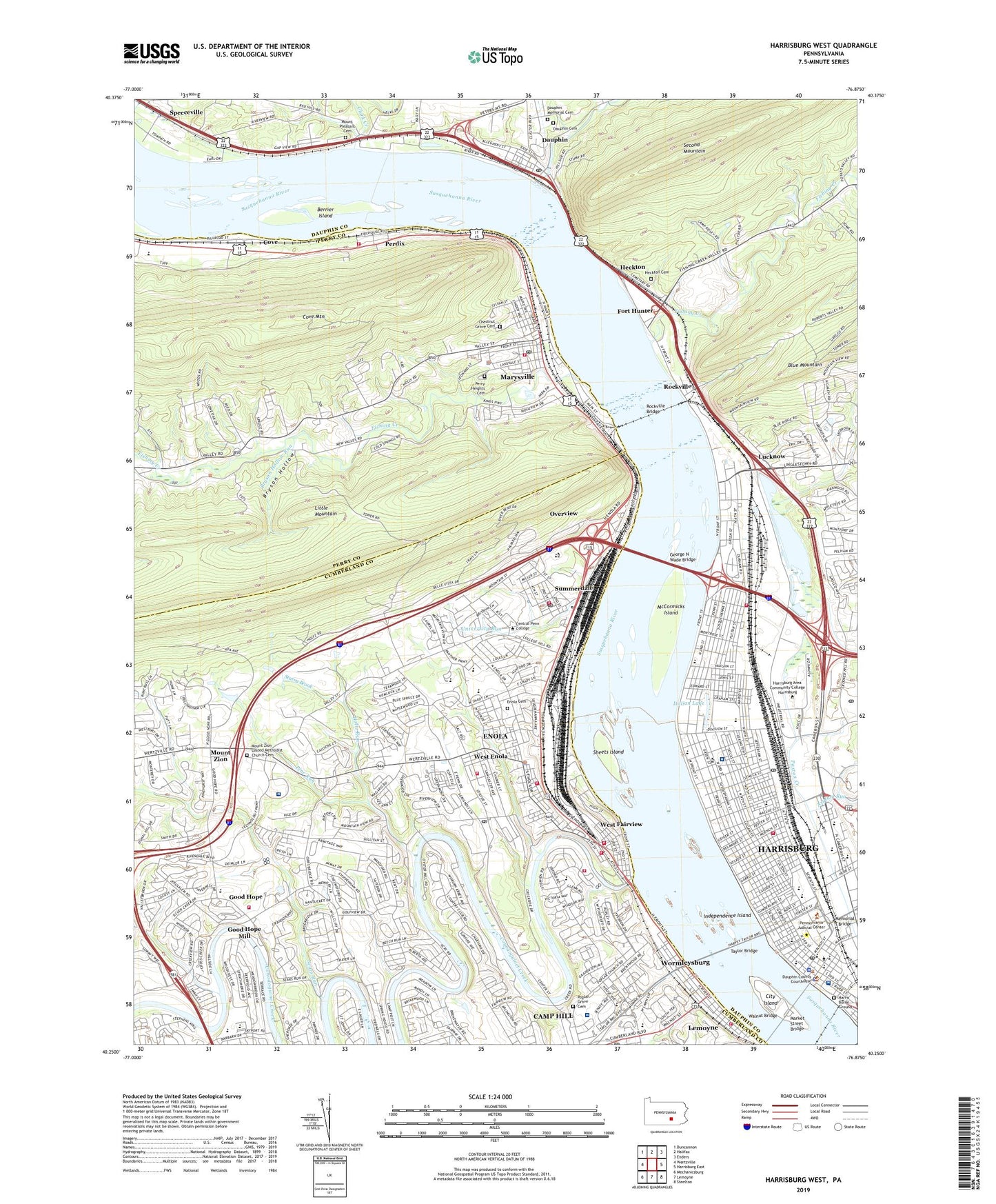
2019 topographic map quadrangle Harrisburg West in the state of Pennsylvania. Scale: 1:24000. Based on the newly updated USGS 7.5' US Topo map series, this map is in the following counties: Dauphin, Cumberland, Perry. The map contains contour data, water features, and other items you are used to seeing on USGS maps, but also has updated roads and other features. This is the next generation of topographic maps. Printed on high-quality waterproof paper with UV fade-resistant inks.
Quads adjacent to this one:
West: Wertzville
Northwest: Duncannon
North: Halifax
Northeast: Enders
East: Harrisburg East
Southeast: Steelton
South: Lemoyne
Southwest: Mechanicsburg
Contains the following named places: Academy of Medicine, Adam Ricci Community Park, Adams Street School, Advanced Technology Education Center, Alliance Church, Anne Hall Apartments, Asylum Run, Bart A Milano Hall, Beaufort Farms, Benjamin Franklin Elementary School, Berrier Island, Boas School, Bollinger Hall, Borough of Dauphin, Borough of Marysville, Borough of West Fairview, Borough of Wormleysburg, Boyer and Farmhouse and Barn, Boyer Run, Braxton Park, Broad Street Market, Bryson Hollow, Bryson Hollow Run, Cameron School, Camp Curtain Early Childhood School, Camp Hill Post Office, Camp Reily, Chapel Hill Church, Charles T Jones Library, Chestnut Grove Cemetery, Chestnut Street School, Citizens Fire Company 1 of Enola Station 18, City Island, City of Harrisburg, Clark Creek, Conodoguinet Creek, Cove, Coventry Close, Coxtown, Creekside Volunteer Fire Company 21, Dauphin, Dauphin Cemetery, Dauphin County Sheriff's Office, Dauphin Memorial Cemetery, Dauphin Post Office, Delaware and Wallace Park, Downey Early Childhood School, East Pennsboro Ambulance Service Station 75, East Pennsboro Area Middle School, East Pennsboro Area Senior High School, East Pennsboro Police Department, Enola, Enola Cemetery, Enola Census Designated Place, Enola Post Office, Enola Run, Enola Yards, Federal Square Post Office, Fishing Creek, Fort Hunter, Fort Hunter Museum, Fourth and Dauphin Park, Fox Ridge Court, Fred Hall Apartments, Gale Hall Apartments, George N Wade Bridge, Glenvale, Good Hope, Good Hope Mill, Good Hope School, Gorgas Park, Governors Mansion, Grandview Acres, Hamilton Elementary School, Hampden School, Hampden Township Volunteer Fire Company Good Hope Road Station 30, Hampden Village Mobile Home Park, Harris Burial Ground, Harrisburg, Harrisburg Academy, Harrisburg Area Community College, Harrisburg Bureau of Fire Station, Harrisburg Bureau of Fire Station 1, Harrisburg Catholic Elementary School, Harrisburg City Bureau of Police, Harrisburg Country Club, Harrisburg Industrial Park, Harrisburg Post Office, Harrisburg Shopping Center, Harrisburg State Hospital, Harsco Heliport, Heckton, Heckton Cemetery, Heckton Church, Hillside Village, Holtz Run, Holy Spirit Heliport, Holy Spirit Hospital, Independence Island, Italian Lake, Italian Park, Jackson Lick, John Harris Mansion, Kathl Hall Apartments, Keen School, Kids on Campus Child Development Center, Kingwood, Knob Point, Lambs Gap Run, Lions Park, Lucknow, Market Street Bridge, Marysville, Marysville Fire Company Station 6, Marysville Police Department, Marysville Post Office, McCormicks Island, Memorial Bridge, Midway Fire Company Station 17, Midway School, Montrose Park, Mount Pleasant Cemetery, Mount View, Mount View Airfield, Mount View Airport, Mount Zion, Mount Zion United Methodist Church, Mount Zion United Methodist Church Cemetery, Mountain Dale, Mountain View Estates, Negly Park, Northeast Fire and Rescue Station 1, Northeast Fire and Rescue Station 2, Our Lady of the Blessed Sacrament School, Overview, Penn and Dauphin Park, Penn and Sayford Park, Penn State Hershey Rehabilitation, Pennsylvania Capitol, Pennsylvania State Hospital, Perdix, Perdix Fire Company Station 11, Perry Heights Cemetery, Pine Run, Pinnacle Health Hospital Harrisburg Campus, Poplar Grove Cemetery, Rescue Fire Company Station 37 - 1, Ridgeland, Riverside School, Rockville, Rockville Bridge, Ronald Reagan Federal Building and Courthouse, Saint Marks United Methodist Church, Saint Paul Lutheran Church, Salem Church, Sears Run, Select Specialty Hospital at Polyclinic Medical Center, Seventh and Radnor Park, Shaull Elementary School, Sheets Island, Sherwood Park, Speeceville, Starry Brook, State Farm Show Building, State Game Land No. 319, State Game Lands No 211, Steele Elementary School, Steelton Highspire Vocational Technical School, Stony Creek, Stony Creek Reservoir, Strawberry Square, Summerdale, Summerdale Plaza, Summerdale Post Office, Summit Street School, Sylvan Street School, Taylor Bridge, Teri Hall Apartments, Todd Hall Apartments, Township of East Pennsboro, Township of Hampden, Treemont, University Center, University Run, Uptown Plaza, Uptown Post Office, Valley Road Building, Walnut Bridge, Water Gap Observation Tower, WCMB-AM (Harrisburg), West Creek Hills, West Creek Hills School, West Enola, West Enola Fire Company Station 17, West Fairview, West Fairview Census Designated Place, West Fairview Forest Fire and Conservation Company, West Shore Bureau of Fire Station 2-13, West Shore Country Club, West Wing, Westwood Village, WHP-AM (Harrisburg), WHTM-TV (Harrisburg), Wildwood Dam, Wildwood Lake, Wildwood Lake Nature Center, Wildwood Park, William Penn High School, Windsor Farms, WKBO-AM (Harrisburg), WMSP-FM (Harrisburg), Wormleysburg, WSFM-FM (Harrisburg), WTPA-FM (Harrisburg), ZIP Codes: 17025, 17093, 17101, 17102, 17110, 17120