MyTopo
Mechanicsburg Pennsylvania US Topo Map
Couldn't load pickup availability
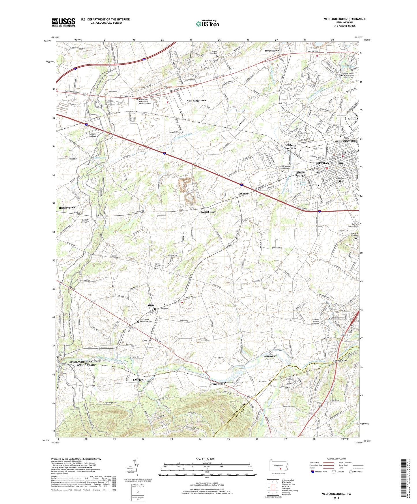
2023 topographic map quadrangle Mechanicsburg in the state of Pennsylvania. Scale: 1:24000. Based on the newly updated USGS 7.5' US Topo map series, this map is in the following counties: Cumberland, York. The map contains contour data, water features, and other items you are used to seeing on USGS maps, but also has updated roads and other features. This is the next generation of topographic maps. Printed on high-quality waterproof paper with UV fade-resistant inks.
Quads adjacent to this one:
West: Carlisle
Northwest: Shermans Dale
North: Wertzville
Northeast: Harrisburg West
East: Lemoyne
Southeast: Wellsville
South: Dillsburg
Southwest: Mount Holly Springs
This map covers the same area as the classic USGS quad with code o40077b1.
Contains the following named places: Allen, Allenberry Playhouse, Anderson School, Bailey School, Bakers Church Cemetery, Bell School, Berkshire Hills, Bethel Cemetery, Bethel Church, Borough of Mechanicsburg, Brandtsville, Brindle School, Brindles School, Broad Street Elementary School, Carroll Manor, Center Square Park, Chestnut Hill, Chestnut Hill Cemetery, Churchtown, Churchtown Mennonite Cemetery, Citizens Fire and Rescue Company Station 27, Cocklins Church Graveyard, Coover Farm Cemetery, Country Estates, Cumberland Valley High School, D and M Junction, Dillsburg Junction, Dogwood Run, Ege Burial Plot, Fishers Run, Garrett Grove School, Gibble Farm Cemetery, Givler School, Heberling School, Hidden Spring, Hogestown, Independent School, Kingtown, Kohlertown School, Le High Park, Leidighs, Liebys Trailer Park, Lincoln Cemetery, Lines School, Locust Point, Longsdorf Cemetery, Maple Grove School, Mechanicsburg, Mechanicsburg Area Intermediate School, Mechanicsburg Area Senior High School, Mechanicsburg Borough Police Department, Mechanicsburg Cemetery, Mennonite Church, Middle School West, Monroe Elementary School, Monroe Fire Company Station 25, Mount Oliver Campgrounds, Mount Zion Cemetery, Mount Zion Evangelical Methodist Cemetery, Mummas School, Neiderer Airport, New Kingston Station, New Kingstown, New Kingstown Census Designated Place, New Kingstown Fire Company Station 33, New Kingstown Post Office, Northside Elementary School, Oak Grove School, Old Graveyard, Reading Banks, Rifes School, Rose Garden, Rose Garden Park, Rosegarden, Roxbury, Salem Church, Silver Spring, Silver Spring Ambulance and Rescue Station 72, Silver Spring Community Fire Company Station 31, Silver Spring Elementary School, Silver Spring Meeting House, Silver Spring Presbyterian Church Cemetery, Soldier and Sailor Memorial Park, Stony Ridge, Strickler Graveyard, Sunnyland, Taylor Aviation Air Field, Township of Monroe, Trindle Spring, Trindle Springs, Trindle Springs Lutheran Cemetery, Valley Stream Estates, Washington Fire Company Station 28, Webercroft, White Rock Acres, Williams Grove, Williams Grove Heliport, Williams Grove Park, Williams Mill, ZIP Codes: 17007, 17050, 17055, 17072