MyTopo
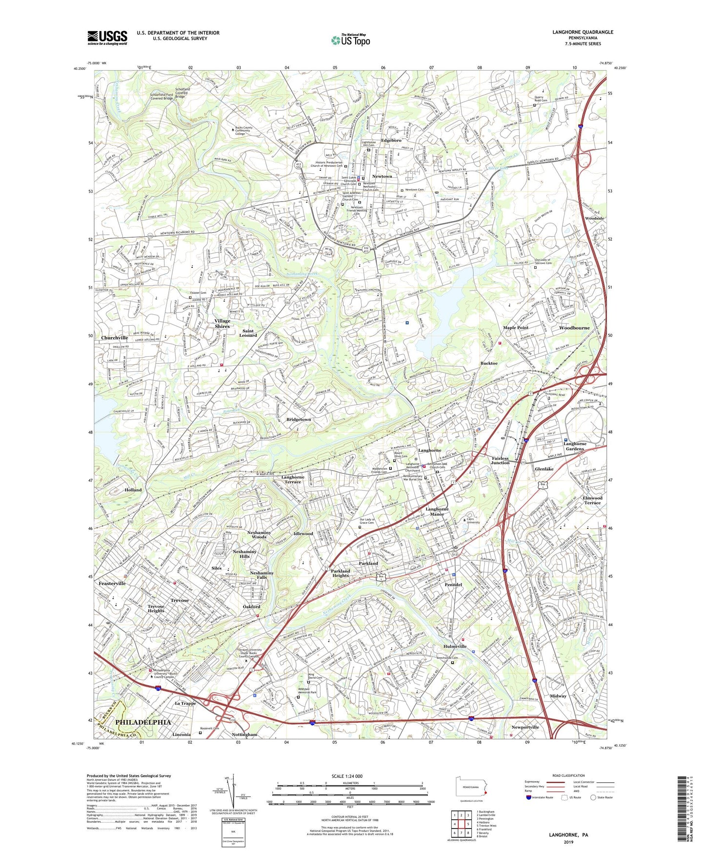
Langhorne Pennsylvania US Topo Map
Couldn't load pickup availability
2019 topographic map quadrangle Langhorne in the state of Pennsylvania. Scale: 1:24000. Based on the newly updated USGS 7.5' US Topo map series, this map is in the following counties: Bucks, Philadelphia. The map contains contour data, water features, and other items you are used to seeing on USGS maps, but also has updated roads and other features. This is the next generation of topographic maps. Printed on high-quality waterproof paper with UV fade-resistant inks.
Quads adjacent to this one:
West: Hatboro
Northwest: Buckingham
North: Lambertville
Northeast: Pennington
East: Trenton West
Southeast: Bristol
South: Beverly
Southwest: Frankford
Contains the following named places: Assumption School, Barix Clinics of Pennsylvania, Beechwood Cemetery, Belmont Hills, Bergen Dam, Bethlehem African Methodist Episcopal Church Cemetery, Borough of Hulmeville, Borough of Langhorne, Borough of Langhorne Manor, Borough of Newtown, Borough of Penndel, Brenwood, Briarwood, Bridgetown, Bristol Plaza, Brookside, Brownsville, Buck Hills Acres, Bucks County Business Park, Bucks County Community College, Bucktoe, Buehl Field, Calico Corner, Chancellor Street School, Churchville Census Designated Place, Churchville County Park, Cliveden, Concord Park, Core Creek, Core Creek County Park, Core Creek Dam, Core Creek Reservoir, Deer Dale, Deerfield, Deerfield North, Eastern Dawn Mobile Home Park, Eastern State School and Hospital, Edgeboro, Elmwood Terrace, Everett School, Fairless Junction, Feaster - Van Horn Cemetery, Feasterville Census Designated Place, Feasterville Farms, Feasterville Heights, Feasterville-Trevose Census Designated Place, Finney Dam, Flowers Mill, Forsythia Gate, Foster Hollow County Park, Friends School, George School, George School Station, Giles and Ransome Airport, Glenlake, Goventry Hamlet, Green Valley, Hamilton Court, Hampton Bridge, Hampton Estates, Hampton Hills, Headley Trace, Heights of Newtown, Hellings Corner, Highland Park, Hillcrest Farms, Hillcrestshire, Historic Presbyterian Church of Newtown Cemetery, Holland, Holland Acres, Holland Farms, Holland Park, Holland Shopping Center, Holland Station, Holland Village Shopping Center, Hollybrooke, Hulmesville Lake, Hulmeville, Hulmeville Dam, Hulmeville Terrace, Idlewood, Ironworks Creek, Ironworks Dam, Janney, Juniper Hill, King David Memorial Park, La Trappe, Lake Luxembourg, Lake Neshaminy, Langhorne, Langhorne Country Club, Langhorne Crest, Langhorne Gables, Langhorne Gardens, Langhorne Manor, Langhorne Methodist Churchyard, Langhorne Shopping Center, Langhorne Square, Langhorne Station, Langhorne Terrace, Liconia Park, Lighthouse Hill Cemetery, Linconia, Linton Hill Farm, Lower Dam, Lower Orchard, Maple Point, Maple Valley, Metropolitan Industrial Park, Middletown Friends Cemetery, Midway, Mill Creek, Mill Creek Falls, Mill Creek Valley Park, Millway Farms, Mount Olive Cemetery, Neshaminy, Neshaminy Falls, Neshaminy Falls Station, Neshaminy Heights, Neshaminy Highlands, Neshaminy Hills, Neshaminy Industrial Park, Neshaminy Mall, Neshaminy Square Shopping Center, Neshaminy Valley, Neshaminy Valley Village, Neshaminy Woods, Newportville Gardens, Newportville Manor, Newtown, Newtown Cemetery, Newtown Creek, Newtown Crossing, Newtown Dam, Newtown Friends Meeting Cemetery, Newtown Industrial Commons, Newtown Methodist Church Cemetery, Newtown Station, Northampton Country Club, Oakford, Old Mill Woods, Our Lady of Grace Cemetery, Our Lady of Sorrows Cemetery, Oxford Valley Mall, Parkland, Parkland Heights, Parkland Station, Penn Valley Mobile Home Park, Penndel, Penns Commons, Penns Court, Pennwood, Pheasant Run, Philadelphia Suburban Dam, Pine Run, Pine Watson Shopping Center, Playwicki Park, Pleasantville, Plumbridge, Poquessing Creek Park, Quarry Road Cemetery, Ramblewood, Red Rose Gate, Revoluntionary War Burial Site, Richlieu, Ridings of Newtown, Roosevelt Memorial Park, Rosedale Memorial Park, Roxton Station, Saint Andrews Catholic Church Cemetery, Saint Leonard, Saint Lukes Episcopal Church Cemetery, Saint Mary Medical Center, Salem Point, Schoefield Ford Covered Bridge, Scholfield Covered Bridge, Scottsville Industrial Park, Siles, Silver Lake, Silver Lake at Newtown, Snowball Gate, Spring Garden, Spring Garden Dam, Spring Garden Mill Farms, Springfield Lake, Stott/Private Airport, Strawberry Ridge, Sturbridge, Suburban Lake, Summit Square Shopping Center, Summit Trace, Sunny Hill, Sweetwater Farms, Tareyton Estates, The Madrid, The Meadows, Top of the Hill, Township of Lower Southampton, Township of Middletown, Township of Newtown, Treeline Estates, Trevose, Trevose Census Designated Place, Trevose Heights, Trevose Shopping Center, Trevose Square Shopping Center, Trevose Station, Twin Oaks, Tyler State Park, Upper Dam, Upper Orchard, Valley View Estates, Village Center Shopping Center, Village Shires, Village Shires Census Designated Place, Villas of Middletown, Washington Village, White House, Willow Green North, Windmill Village, Wood Lake, Woodbourne, Woodbourne Census Designated Place, Woodbourne Station, Woodland Estates, Woodlyn, Woodlyn Crossing, Woodside, Worstalls Farms, Worthington Mill Farms, ZIP Codes: 18954, 19047, 19053, 19056