
MyTopo
Lehighton Pennsylvania US Topo Map
Couldn't load pickup availability
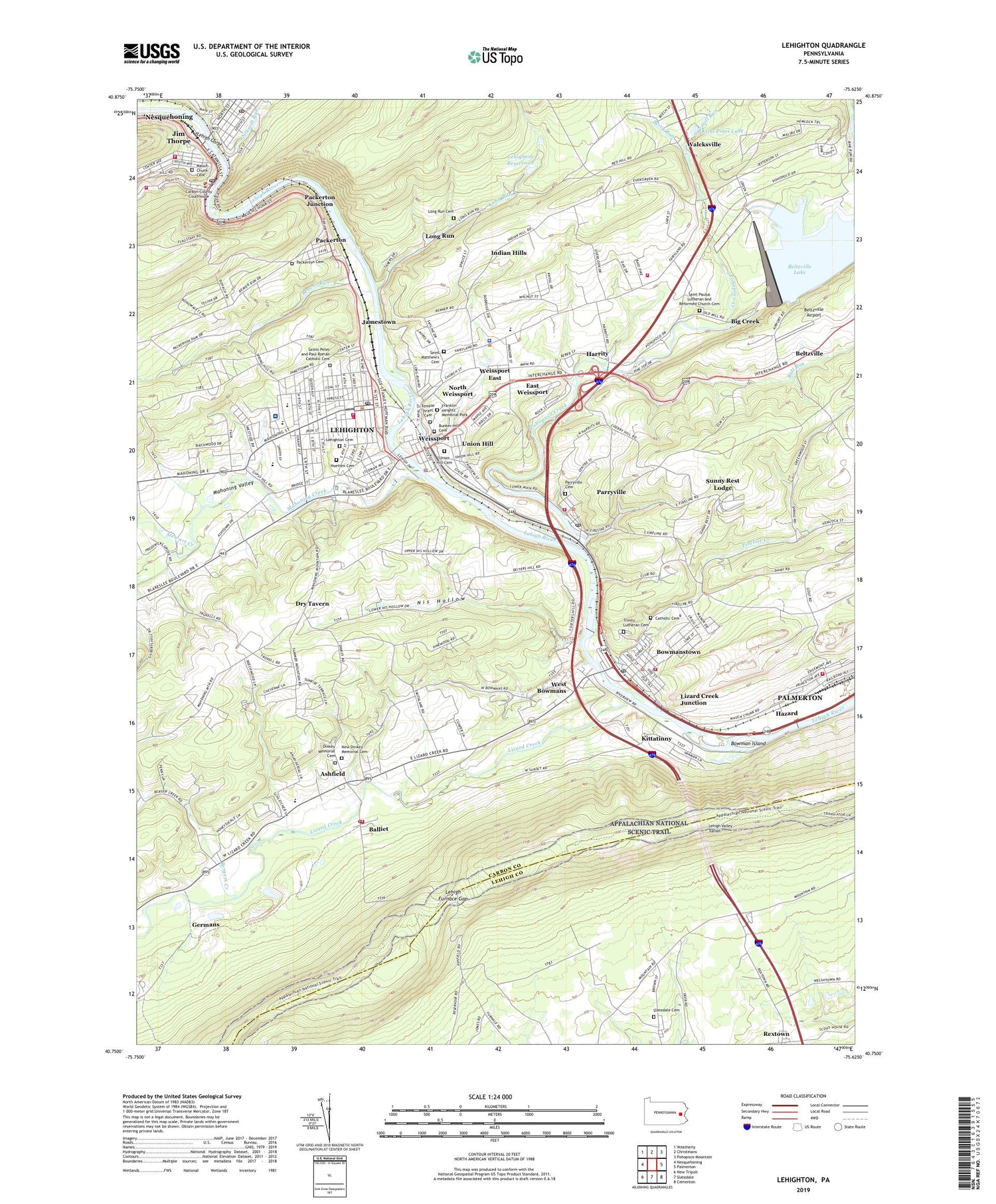
2023 topographic map quadrangle Lehighton in the state of Pennsylvania. Scale: 1:24000. Based on the newly updated USGS 7.5' US Topo map series, this map is in the following counties: Carbon, Lehigh. The map contains contour data, water features, and other items you are used to seeing on USGS maps, but also has updated roads and other features. This is the next generation of topographic maps. Printed on high-quality waterproof paper with UV fade-resistant inks.
Quads adjacent to this one:
West: Nesquehoning
Northwest: Weatherly
North: Christmans
Northeast: Pohopoco Mountain
East: Palmerton
Southeast: Cementon
South: Slatedale
Southwest: New Tripoli
This map covers the same area as the classic USGS quad with code o40075g6.
Contains the following named places: Ashfield, Ashfield Post Office, Balliet, Bear Mountain, Beaver Run, Beltzville, Beltzville Airport, Bergers Creek, Berry Run, Big Creek, Borough of Bowmanstown, Borough of Jim Thorpe, Borough of Lehighton, Borough of Parryville, Borough of Weissport, Bowman Island, Bowmanstown, Bowmanstown Post Office, Bowmanstown Volunteer Fire Company District 2, Bull Run, Bunker Hill Cemetery, Carbon County Sheriff's Office, Catholic Cemetery, Cummings School, David Elementary School, Diligent Fire Company District 11, Dinkey Memorial Cemetery, Dinkey Memorial Church, Dry Tavern, East Penn Elementary School, East Penn Township Volunteer Fire Company District 3, East Weissport, Evergreens Golf Course, Fire Line School, Fireline Creek, First Ward Elementary School, Flagstaff Mountain Overlook, Flagstaff Mountain Park, Franklin Elementary School, Franklin Heights Memorial Park, Franklin Heights School, Franklin Township Police Department, Franklin Township Volunteer Fire Company District 4, Germans, Harrity, Hazard, Hazard School, Heilman Dam, Huetten Cemetery, Indian Hills, Indian Hills School, Jamestown, Jim Thorpe Area Junior High School, Jim Thorpe Post Office, Kittatinny, Kittatinny School, Kriss Pines Lake, Lehigh Furnace Gap, Lehigh Gorge, Lehigh Valley Tunnel, Lehighton, Lehighton Airport, Lehighton Ambulance District 5, Lehighton Area High School, Lehighton Area Junior High School, Lehighton Borough Police Department, Lehighton Cemetery, Lehighton Fire Department District 5, Lehighton Fire Department Station 2, Lehighton Post Office, Lehighton Reservoirs, Lizard Creek, Lizard Creek Junction, Long Run, Long Run Cemetery, Long Run Reservoir Number One Dam, Mahoning Creek, Mahoning Creek Dam, Mahoning Hills, Mahoning Valley, Mauch Chunk Cemetery, Mauch Chunk Creek, Mauch Chunk Tower, Neeb Airport, New Dinkey Memorial Cemetery, Nis Hollow, Nis Hollow School, North Weissport, Number One Dam, Number Three Dam, Number Two Dam, Packerton, Packerton Cemetery, Packerton Junction, Parryville, Parryville Cemetery, Parryville Lake, Parryville Post Office, Parryville Station, Parryville Volunteer Fire Company District 8, Peoples Church, Phoenix Hose Company District 11, Pine Run, Pohopoco Creek, Pohopoco Creek Dam, Regional EMS and Critical Care Ambulance, Reigner School, Rextown, Robertson Run, Saint Luke's Hospital - Gnaden Huetten Campus, Saint Matthew's Cemetery, Saint Matthews Church, Saint Paulus Lutheran and Reformed Church Cemetery, Saint Peters Church, Saints Peter and Paul Roman Catholic Cemetery, Salem Church, Sawmill Run, Shull-David Elementary School, Silkmill Run, Slatedale Cemetery, State Game Lands Number 217, Stewart Creek, Stone Ridge, Stone Ridge School, Sunny Rest Airport, Sunny Rest Lodge, Temple Israel Cemetery, Third Ward Elementary School, Township of East Penn, Township of Franklin, Trinity Lutheran Cemetery, Union Hill, Union Hill Cemetery, Wahnetah Post Office, Walcksville, Weissport, Weissport Borough Police Department, Weissport East Census Designated Place, West Bowmans, West End Fire Company District 7, West Leechburg Reservoir Dam, WYNS-AM (Lehighton), ZIP Codes: 18030, 18212, 18235, 18244


