MyTopo
Meadville Pennsylvania US Topo Map
Couldn't load pickup availability
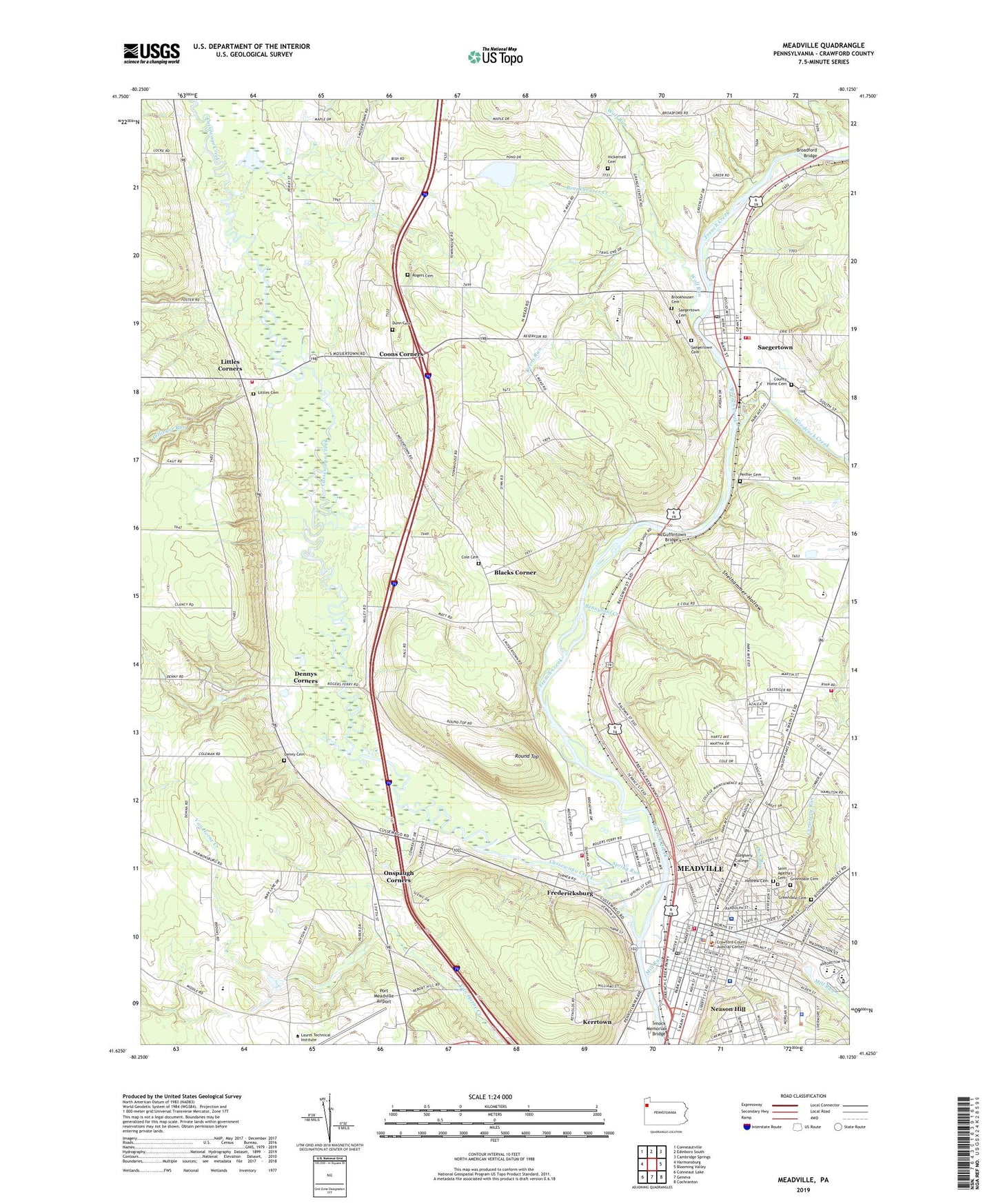
2023 topographic map quadrangle Meadville in the state of Pennsylvania. Scale: 1:24000. Based on the newly updated USGS 7.5' US Topo map series, this map is in the following counties: Crawford. The map contains contour data, water features, and other items you are used to seeing on USGS maps, but also has updated roads and other features. This is the next generation of topographic maps. Printed on high-quality waterproof paper with UV fade-resistant inks.
Quads adjacent to this one:
West: Harmonsburg
Northwest: Conneautville
North: Edinboro South
Northeast: Cambridge Springs
East: Blooming Valley
Southeast: Cochranton
South: Geneva
Southwest: Conneaut Lake
This map covers the same area as the classic USGS quad with code o41080f2.
Contains the following named places: Allegheny College, Allegheny Hall, Arnold Hall of Music, Arter Hall, Bennyhoof Creek, Bethesda Home, Blacks Corner, Borough of Saegertown, Broadford Bridge, Broadford School, Brookhouser Cemetery, Brookhouser Creek, Brookhouser Elementary School, Brooks Dining Hall, Burns School, Caflisch Hall, Cemetery Run, Chest Park Mini Mall, City of Meadville, Cole Cemetery, Compton School, Coons Corners, Cora Clark Park, County Home Cemetery, Crawford County Area Vocational Technical School, Crawford County Sheriff's Department, Curtis School, Cussewago Creek, Cussewago Creek Access Area, Denny Cemetery, Denny School, Dennys Corners, Dick Run, Dillinger Run, Doane Hall (Art), Doane Hall of Chemistry, Dunn Cemetery, Dunn School, East End Elementary School, First District Elementary School, Ford Memorial Chapel, Forman School, Fredericksburg, Fredericksburg Census Designated Place, Grange Centre, Greendale Cemetery, Hailwood Golf Course, Hayfield Hose Company Department 12, Hebrew Cemetery, Henderson Campus Center, Hickernell Cemetery, Hillcrest Park, Hudekoper Park, Hulings Hall, Huller School, Kerns Run, Kerrtown, Kerrtown Census Designated Place, Littles Cemetery, Littles Corners, McGuffintown Bridge, McKinley's Food Court, Meadvile Post Office, Meadville, Meadville Area Ambulance Service Department 33, Meadville Area High School, Meadville Area Junior High School, Meadville Central Fire Department 16, Meadville City Police Department, Meadville Dam, Meadville Mall, Meadville Medical Center, Meadville Medical Center- Grove Street, Meadville Volunteer Fire and Rescue Company, Mellon Recreation Building, Mill Run, Montgomery Gym, Neason Hill, North End School, Oddfellows Building, Onspaugh Corners, Peiffer Cemetery, Pelletier Library, Port Meadville Airport, Rainbow Lake, Ravine-Narvik Hall, Reis Hall, Richmond School, Robertson Athletic Complex, Rogers Cemetery, Round Top, Ruter Hall, Saegertown, Saegertown Cemetery, Saegertown High School, Saegertown Middle School, Saegertown Post Office, Saegertown Volunteer Fire Department 19, Saint Agatha's Cemetery, Schultz Banquet Hall, Second District Elementary School, Shady Brook Park, Shafer Auditorium, Shelhammer Hollow, Smock Memorial Bridge, Spauldings Incorporated Airport, Spencer Hospital, Spring Run, Third District School, Township of Hayfield, Township of Vernon, Venango Valley Golf Course, Vernon Township Volunteer Fire Department 27, WARC-FM (Meadville), West Mead District 2 Volunteer Fire Department 29, West Mead Police Department, Whispering Pines Golf Course, Winslow Health Center, Wise Sport and Fitness Center, WMGW Radio Tower (Ticonderoga), WMGW-AM (Meadville), Wolf Run, Woodcock Creek, WYSS-FM (Saegertown), WZPR-FM (Meadville), ZIP Codes: 16335, 16433