MyTopo
Nazareth Pennsylvania US Topo Map
Couldn't load pickup availability
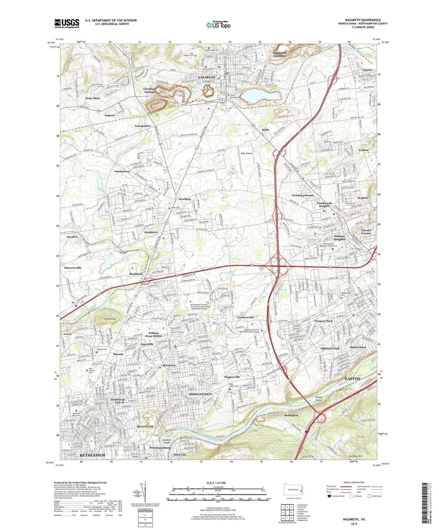
2023 topographic map quadrangle Nazareth in the state of Pennsylvania. Scale: 1:24000. Based on the newly updated USGS 7.5' US Topo map series, this map is in the following counties: Northampton. The map contains contour data, water features, and other items you are used to seeing on USGS maps, but also has updated roads and other features. This is the next generation of topographic maps. Printed on high-quality waterproof paper with UV fade-resistant inks.
Quads adjacent to this one:
West: Catasauqua
Northwest: Kunkletown
North: Wind Gap
Northeast: Bangor
East: Easton
Southeast: Riegelsville
South: Hellertown
Southwest: Allentown East
This map covers the same area as the classic USGS quad with code o40075f3.
Contains the following named places: Airport Plaza Shopping Center, Altonah, Altonah Cemetery, Bayard Park, Bethel Memorial Church, Bethlehem, Bethlehem Area Vocational-Technical School, Bethlehem Boating Club, Bethlehem Catholic High School, Bethlehem City Fire Department Lincoln Station, Bethlehem Easton Airport, Bethlehem Plaza, Bethlehem Township Fire Department Station 17, Bethlehem Township Park, Bethlehem Township Police Department, Bethlehem Township Volunteer Fire Company EMS Heliport, Bethlehem View, Borough of Freemansburg, Borough of Nazareth, Borough of Tatamy, Boyer School, Brodhead, Bugs Airport, Bull Run, Bushkill Park, Butler School, Butztown, Butztown Post Office, Camelhump, Christian Springs, Church Hill Airport, City of Bethlehem, City of Bethlehem Emergency Medical Services, Coordinated Health Orthopedic Hospital, Curries Ferry, Dryland, Dryland Church, East Branch Monocacy Creek, East Hills, East Hills Park, Eastlawn Gardens Census Designated Place, Easton High School, Easton Plaza, Edelman School, Edgeboro School, Edward Tracy Elementary School, Elwood School, Fairview School, Farmersville, Farmersville Elementary School, Floyd R Shafer Elementary School, Fox School, Freedom High School, Freemansburg, Freemansburg Elementary School, Freemansburg Police Department, Freemansburg Volunteer Fire Department Station 12, Gaffney Hill, Georgetown, Gethsemane Cemetery, Gospel Church, Governor Wolf Elementary School, Gracedale County Home, Green Pond, Green Pond Golf Course, Greenwood Cemetery, Hamilton School, Hanoverville, Hecktown, Hecktown Volunteer Ambulance Corps, Hecktown Volunteer Fire Company Station 53, Heimple Park, Highland Park, Hollo, Holy Family Cemetery, Holy Family School, Holy Ghost Ukrainian Catholic Cemetery, Holy Saviour Cemetery, Hope Cemetery, Hugh Moore Park, Island Park, Jackson School, Jones Mill, Lafayette School, Laubach Island, Lehigh Valley Post Store Post Office, Liberty High School, Lime Ridge, Lincoln Elementary School, Lincoln Park, Lincoln Terrace, Little Bushkill Creek, Louise W Moore Park, Lower Nazareth Elementary School, Lower Saucon Fire Rescue Steel City Station 63, Macada, Marvine Elementary School, Memorial Park Cemetery, Middletown, Middletown Census Designated Place, Miller Heights Elementary School, Moravian Seminary for Girls, Mount Hope, Nancy Run, Nancy Run Fire Department Station 14, Nazareth, Nazareth Ambulance Corps, Nazareth Area Junior High School, Nazareth Area Senior High School, Nazareth Carrier Annex Post Office, Nazareth Moravian Cemetery, Nazareth Post Office, New Centerville, Newburg, Newburg Homes, Northampton Country Club, Northampton Memorial Shrine Cemetery, Northdale Park, Northeast Junior High School, Northwood Heights, Notre Dame High School, Oakland Plaza, Old Orchard, Old Orchard Census Designated Place, Our Lady of Perpetual Help School, Palmer Heights, Palmer Heights Census Designated Place, Palmer Municipal Fire Department Station 2, Palmer Municipal Fire Department Station 27, Palmer Park, Palmer Park Mall, Palmer Post Office, Palmer Township Elementary School, Penn Allen, Posh Heliport, Prospect Park, Redington, Sacred Heart School, Saint Andrews Church, Saint Anns Church, Saint Francis Friary, Saint Johns Cemetery, Saint Johns Church, Saint Marks Church, Saint Pauls Church, Saint Thomas Church, Sell Field, Smoketown, Spring Garden Elementary School, Steel City, Stefko Boulevard Shopping Center, Steuben, Suburban Emergency Medical Services Station 27 - South Division, Tadmor, Tatamy, Tatamy Borough Police Department, Tatamy Post Office, Thomasburg School, Township of Bethlehem, Township of Lower Nazareth, Township of Palmer, Township of Upper Nazareth, Turkey Island, Union School, Vigilance Hose Company Station 50, Wagnerville, Walters, Welagamika, William Penn Manor, ZIP Codes: 18020, 18045, 18085