MyTopo
Allentown East Pennsylvania US Topo Map
Couldn't load pickup availability
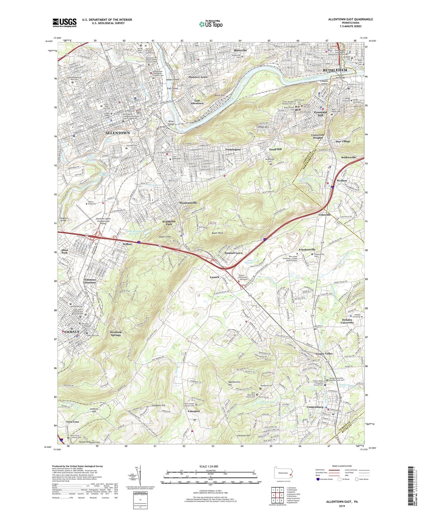
2023 topographic map quadrangle Allentown East in the state of Pennsylvania. Scale: 1:24000. Based on the newly updated USGS 7.5' US Topo map series, this map is in the following counties: Lehigh, Northampton, Bucks. The map contains contour data, water features, and other items you are used to seeing on USGS maps, but also has updated roads and other features. This is the next generation of topographic maps. Printed on high-quality waterproof paper with UV fade-resistant inks.
Quads adjacent to this one:
West: Allentown West
Northwest: Cementon
North: Catasauqua
Northeast: Nazareth
East: Hellertown
Southeast: Quakertown
South: Milford Square
Southwest: East Greenville
This map covers the same area as the classic USGS quad with code o40075e4.
Contains the following named places: Adams Island, Agudath Achim Cemetery, Allen Street Shopping Center, Allentown, Allentown Fire Department Mack South Fire Station, Allentown High School, Allentown Post Office, Allentown Queen City Municipal Airport, Allentown Shopping Plaza, Allentown State Hospital, Alton Park, Applebutter Hill, Aviat Hall, Bauer Rock, Bethlehem High School, Bethlehem Star Tower, Bicentennial, Billera Hall Gymnasium, Blue School, Bogerts Bridge, Borough of Coopersburg, Borough of Emmaus, Borough of Fountain Hill, Brith Sholom Cemetery, Brith Sholom Cemetery Old, Broughal Middle School, Butz Baseball Field, Calvary Bible Fellowship Church Cemetery, Calypso Elementary School, Calypso Island, Cedar Creek, Center Valley, Center Valley Post Office, Central Elementary School, Chappuis Hall, Chestnut Hill, City of Allentown, Cleveland Elementary School, Colesville, Conmy Hall, Coopersburg, Coopersburg Elementary School, Coopersburg Post Office, Crystal Spring, DeChantal Hall, DeSales University, DeSales University Census Designated Place, Devonshire Park, Dooling Hall, Dutch Hill, East Allentown, East Penn Yards, East Pennsylvania Junction, Eastern Pilgrim College, Emil Zola Cemetery, Emmaus, Emmaus Evangelical Cemetery, Emmaus Junction, Emmaus Moravian Cemetery, Emmaus Post Office, Eves Island, Fairview Cemetery, Farmington, Fasching Track, Fifteenth and Allen Streets Shopping Center, Fifteenth Street Spring, Fountain Hill, Fountain Hill Cemetery, Fountain Hill Elementary School, Fountain Hill High School, Fountain Park, Francis D Raub Middle School, Friedensville, Friedensville Cemetery, Friedensville School, Fromentin House, Gauff Hill, Go Helistop, Gods Acre Cemetery, Green Meadow at Fountain Hill Cemetery, Gruver School, Hamilton Mall, Hanover Acres, Harrison-Morton High School, Harry S Truman Elementary School, Hartman School, Higbee School, Highland Memorial Park Cemetery, Hill to Hill Bridge, Hiram W Dodd Elementary School, Holy Ghost Cemetery, Hopewell Elementary School, Hurd Science Center, Hursicker School, Immaculate Conception Catholic Cemetery, Irving Park, Jackson Elementary School, Jacquier Center, Jasper Cliffs, Jefferson Elementary School, John Valeniz Park, Jordan Creek, Jordan Park, Keck Park, Kline Island, Lake Thomas, Lanark, Laubach Park, Lehigh Coal and Navigation Canal, Lehigh County Government Center, Lehigh Mountain, Lehigh Park Spring, Lehigh Parkway Elementary School, Lehigh University, Lehigh Valley Dairies, Leiberts Gap, Liberty Bell Elementary School, Limeport, Limeport Hill, Limeport Post Office, Lincoln Early Childhood Center, Lincoln Elementary School, Linden Street Cemetery, Little Lehigh Creek, Little Lehigh Dam, Little Lehigh Park, Louis E Dieruff High School, Lower Milford Township Fire Company 1 Station 13, Mack Park, McKinley Elementary School, McShea Student Union, Moravian Cemetery, Morgenland Cemetery, Mosser Elementary School, Mountainville, Mountainville Shopping Center, Moyers Lake, Nisky Hill Cemetery, Northwood Cemetery, Number Seven Dam, Our Lady of Deliverance Status/Recreation Area, Our Lady of Mount Carmel Cemetery, Overlook Springs, Pa-7 Dam, Parkway Shopping Center, Pine Brook College, Ritter Elementary School, Rittersville Cemetery, Ritterville, Robert Rodale Reserve, Rodale Run, Roosevelt Elementary School, Rosegarden Park, Ruhe Park, Sacred Heart Cemetery, Sacred Heart School, Saint Anns School, Saint Catherines School, Saint Francis School, Saint John the Baptist Slovak Catholic Cemetery, Saint Johns Lutheran and Reformed Cemetery, Saint Joseph Calvary Cemetery, Saint Luke's Hospital - Allentown Campus, Saint Luke's Hospital - Sacred Heart Campus, Saint Marks Cemetery, Saint Pauls Blue Church Cemetery, Saint Paul's Evangelical Lutheran Church Tower Cemetery, Salisbury Junior-Senior High School, Salisbury School, Saucon Mennonite Meeting House Cemetery, Saucon Valley, Saucon Valley Country Club, Seiders School, Seidersville, Sheridan Elementary School, South Mountain Middle School, South Mountain Park, South Mountain Preserve, South Mountain Reservoir, Southern Lehigh High School, Southern Lehigh Middle School, Southside Post Office, St. Luke's University Hospital - Bethlehem Campus, Star Village, Stevens School, Suamme Camp, Summit Lawn, Tocik Hall, Tocik/Conmy Recreation Area, Township of Salisbury, Township of Upper Saucon, Trexler Library, Trexler Middle School, Trout Creek, Trout Creek Park, Tucker House, Tumble Brook, Union - West End Cemetery, Union Terrace Elementary School, University Heights, University Heights I, University Heights II, University Heights III, University Heights Recreation Area, Upper Saucon School, Upper Saucon Volunteer Fire Department Station 27, Vera Cruz, Vera Cruz E C Church Cemetery, Vera Cruz Elementary School, Vera Cruz Station, WAEB-AM (Allentown), Waldheim Park, Washington Elementary School, Washington School, Wedgewood Golf Course, West Park, WFMZ-FM (Allentown), WFMZ-TV (Allentown), WHOL-AM (Allentown), Wilbur, Wills Hall, Wilson School, WLEV-FM (Easton), WLVR-FM (Bethlehem), WLVT-TV (Allentown), Wood School, Woodland Cemetery, Wydnor, ZIP Codes: 18034, 18036, 18049, 18101, 18102, 18103, 18105