MyTopo
Wind Gap Pennsylvania US Topo Map
Couldn't load pickup availability
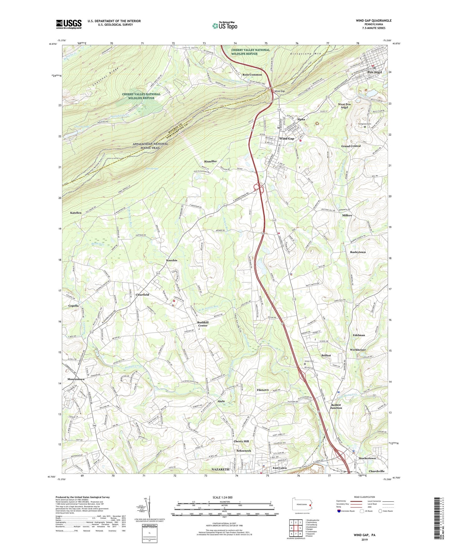
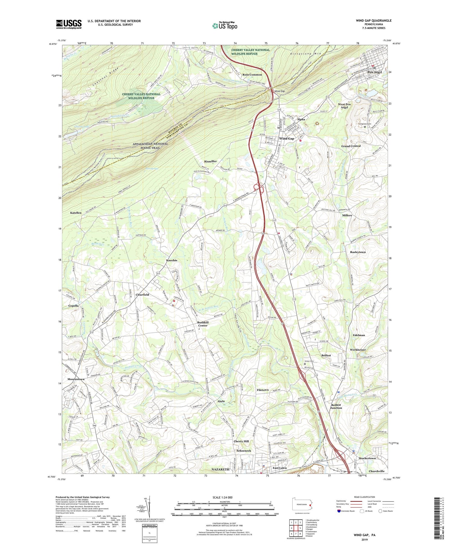
2023 topographic map quadrangle Wind Gap in the state of Pennsylvania. Scale: 1:24000. Based on the newly updated USGS 7.5' US Topo map series, this map is in the following counties: Northampton, Monroe. The map contains contour data, water features, and other items you are used to seeing on USGS maps, but also has updated roads and other features. This is the next generation of topographic maps. Printed on high-quality waterproof paper with UV fade-resistant inks.
Quads adjacent to this one:
West: Kunkletown
Northwest: Brodheadsville
North: Saylorsburg
Northeast: Stroudsburg
East: Bangor
Southeast: Easton
South: Nazareth
Southwest: Catasauqua
This map covers the same area as the classic USGS quad with code o40075g3.
Contains the following named places: Alpha, Aluta, Belfast, Belfast Census Designated Place, Belfast Junction, Belfast Union Cemetery, Benders Church, Blue Mountain Dam, Borough of Pen Argyl, Borough of Stockertown, Borough of Wind Gap, Boulton, Bushkill Center, Bushkill Church, Bushkill School, Bushkill Township Elementary School, Bushkill Township Police Department, Bushkill Township Volunteer Fire Company Station 52, Center School, Central School, Cherry Hill, Chicola Lake, Chicola Lake Dam, Churchville, Clearfield, Copella, Douglassville, East Lawn, Eastlawn Gardens, Edelman, Evergreen Cemetery, Filetown, Friedenthal, Global Medical Transportation Services, Grand Central, Haynes Mill, Horn Springs, Interdenominational Church, Jackson School, Jacobsburg, Jacobsburg State Park, Katellen, Knechts, Leiberts School, Lookout Fire Company Station 32, Mill Dam, Mill Grove School, Millers, Moorestown, Mount View Park Racetrack, Nisky, Northampton County, Pen Argyl, Pen Argyl Junior-Senior High School, Pen Argyl Post Office, Pennsylvania State Police Troop M Belfast Station, Plainfield Township Elementary School, Plainfield Township Volunteer Fire Company Station 36, Rasleytown, Rismiller, Ross Common, Ross Common Dam, Saint Charles Church, Saint Peters Union Church, Saylorsburg Junction, Schoeneck, Schoeneck Moravian Church, Slate Belt Regional Police Department, Sobers Run, Sours Mills, Stockertown, Stockertown Borough Police Department, Stockertown Post Office, Township of Bushkill, Township of Plainfield, Upper Nazareth Fire Department Station 54, Wardsburg, Warren School, Werkheiser, Wesley Church, West Branch Sobers Run, West Pen Argyl, Wind Gap, Wind Gap Ambulance, Wind Gap Fire Company Station 35, Wind Gap Post Office, Windgap Post Office, ZIP Codes: 18064, 18072, 18083, 18091