MyTopo
Red Lion Pennsylvania US Topo Map
Couldn't load pickup availability
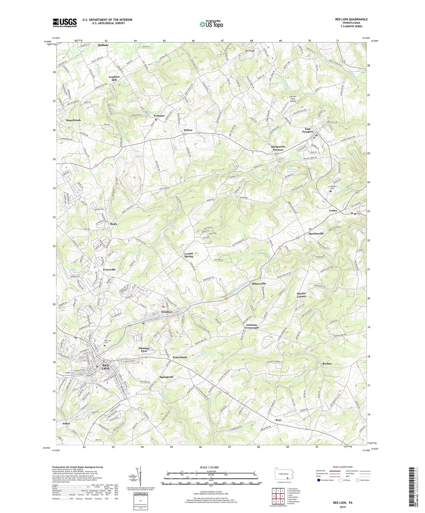
2019 topographic map quadrangle Red Lion in the state of Pennsylvania. Scale: 1:24000. Based on the newly updated USGS 7.5' US Topo map series, this map is in the following counties: York, Lancaster. The map contains contour data, water features, and other items you are used to seeing on USGS maps, but also has updated roads and other features. This is the next generation of topographic maps. Printed on high-quality waterproof paper with UV fade-resistant inks.
Quads adjacent to this one:
West: York
Northwest: York Haven
North: Columbia West
Northeast: Columbia East
East: Safe Harbor
Southeast: Airville
South: Stewartstown
Southwest: Glen Rock
Contains the following named places: Adamsville, Arbor, Beaver Creek, Bethlehem Church, Bittersville, Bittersville School, Borough of East Prospect, Borough of Red Lion, Borough of Windsor, Borough of Yorkana, Brenneman School, Brigadoon, Cabin Creek Dam, Calvary Church, Canadochly Church, Canadochly Valley Ambulance, Cook Creek, Craley, Craley Community Fire Company Station 44, Craley Post Office, Crestwood East, D Evans Farm Airport, Dellinger School, Delroy, East End Church, East Prospect, East Prospect Fire Company Station 42, East Prospect Post Office, East Prospect Reservoir, Edgar C Moore Elementary School, Emanuel Lutheran Church, Emanuel Reformed Church, Fairmount Park, Forest Hills, Freysville, Greystone Farms, Grimms Crossroads, Hallam Station, Holtz, Kaltreider-Benfer Library, Kendale East, Keys, Klein School, Laurel Fire Company 1 Station 37, Leiphart Mill, Locust Grove Elementary School, Locust Spring, Lower Windsor Township Police Department, Magaretta Furnace School, Margaretta Furnace, Margereta Furnace Farms, Martinsville, Mazie C Gable Elementary School, Modern Landfill, Mount Pisgah, Mount Pisgah Church, Nebinger School, Neiam School, Olewiler Cemetery, Orchard Hill, Panorama Hills, Petersburg, Pleasant View, Pleasant View Elementary School, Red Lion, Red Lion Ambulance 37, Red Lion Area Junior High School, Red Lion Area Senior High School, Red Lion Cemetery, Red Lion Country Club, Red Lion Fire Department, Red Lion Post Office, Red Lion Reservoir, Red Lion Stadium, Richmond, Rockey, Saint Paul Church, Salem Church, Samuel S Lewis State Park, Smalls School, Snavelys School, Snyder Corner, Snyder School, Springvale, Sylvan Hills, Thompson School, Township of Lower Windsor, Township of Windsor, Trinity Church, Valley View Park, Warners Airport, WGCB-AM (Red Lion), WGCB-FM (Red Lion), WGCB-TV (Red Lion), Willis School, Windsor, Windsor Church, Windsor Post Office, Windsor Township Elementary School, Winters School, Yorkana, Yorkana Community Fire Company Station 38, Zion Church, ZIP Codes: 17317, 17356, 17366, 17368