MyTopo
Smithfield Pennsylvania US Topo Map
Couldn't load pickup availability
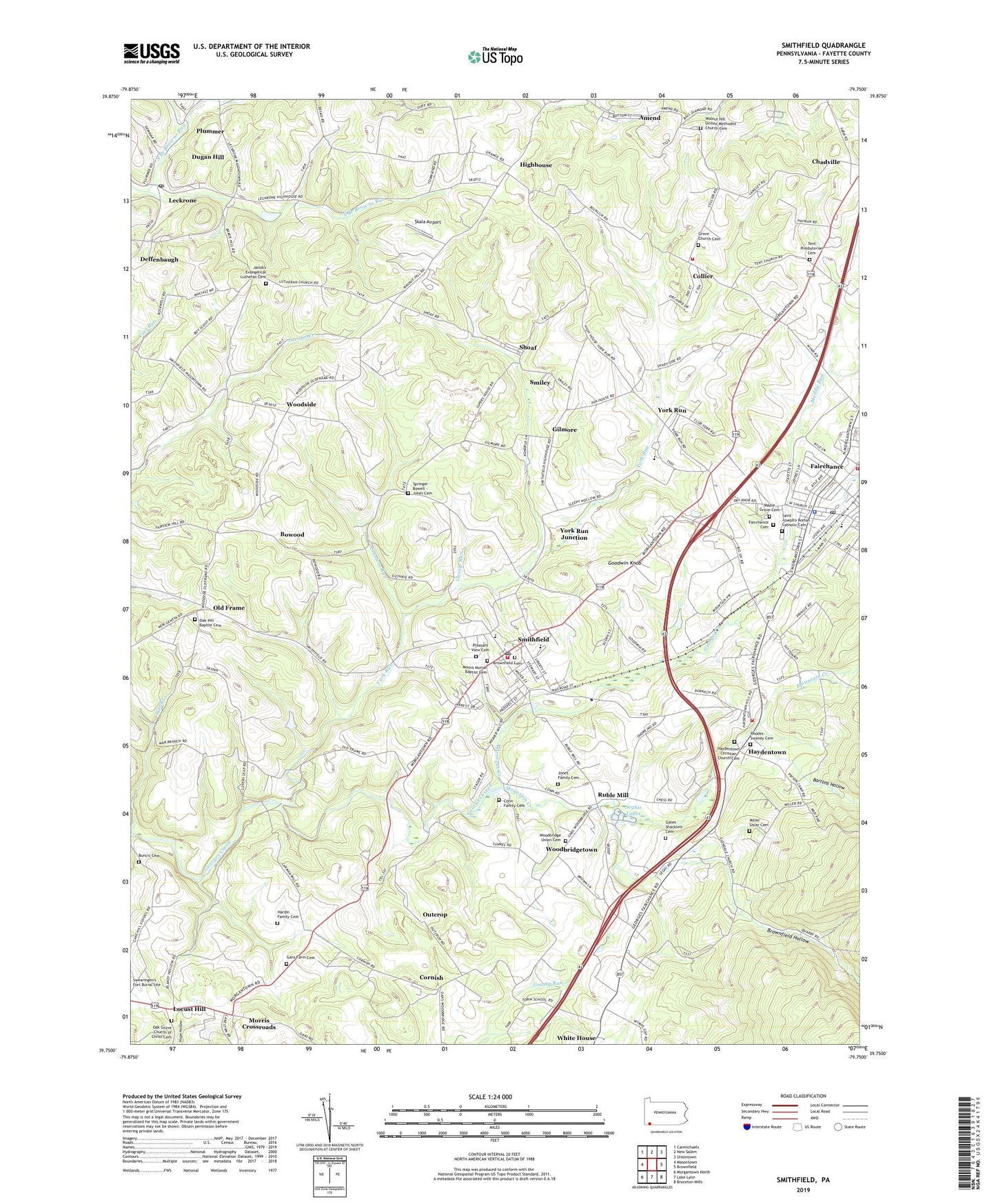
2023 topographic map quadrangle Smithfield in the state of Pennsylvania. Scale: 1:24000. Based on the newly updated USGS 7.5' US Topo map series, this map is in the following counties: Fayette. The map contains contour data, water features, and other items you are used to seeing on USGS maps, but also has updated roads and other features. This is the next generation of topographic maps. Printed on high-quality waterproof paper with UV fade-resistant inks.
Quads adjacent to this one:
West: Masontown
Northwest: Carmichaels
North: New Salem
Northeast: Uniontown
East: Brownfield
Southeast: Bruceton Mills
Southwest: Morgantown North
This map covers the same area as the classic USGS quad with code o39079g7.
Contains the following named places: Amend, Bartons Hollow, Borough of Fairchance, Borough of Smithfield, Bowood, Brownfield Cemetery, Brownfield Hollow, Buncic Cemetery, Chadville, Collier, Collier Volunteer Fire Department Station 9, Conn Family Cemetery, Cores School, Cornish, Crozier Run Branch Junction Station, Croziers Run, Deffenbaugh, Dugan Hill, Emery, Fairchance, Fairchance Cemetery, Fairchance Police Department, Fairchance Post Office, Fairchance Volunteer Fire Department Station 16, Fairchance-Georges School, Gans Farm Cemetery, Gans Hill School, Gates Shacklett Cemetery, Gilmore, Goodwin Knob, Gossip Run, Grace Chapel, Griffin School, Grove Church Cemetery, Hardin Family Cemetery, Haydentown, Haydentown Christian Church Cemetery, Haydentown Volunteer Fire Department Station 50, Highhouse, Jacob's Evangelical Lutheran Cemetery, Jones Family Cemetery, Leckrone, Leckrone Post Office, Lewis Crossing, Locust Hill, Lutheran Church, Lynndale School, Maple Grove Cemetery, Miller Airport, Miller Sisler Cemetery, Morris Crossroads, Mount Moriah Baptist Cemetery, Mount Moriah Church, Mountain Creek, Muddy Run, North Branch Browns Run, Oak Grove Church, Oak Grove Church of Christ Cemetery, Oak Hill Baptist Cemetery, Old Frame, Outcrop, Pauls School, Pleasant Hill Church, Pleasant Hill School, Pleasant View Cemetery, Plummer, Rhodes Swaney Cemetery, Rich Hill School, Ruble Mill, Saint Joseph's Roman Catholic Cemetery, Saint Marys Church, Seghis Lakes, Shoaf, Skala Airport, Smiley, Smithfield, Smithfield Elementary School, Smithfield Post Office, Smithfield Volunteer Fire Department Station 38, South Branch Browns Run, Springer - Bowell - Jones Cemetery, Strum Station, Sulphur Springs Union Chapel, Tent Church, Tent Presbyterian Cemetery, Tobin School, Township of Georges, Township of Nicholson, Valley School, Walnut Hill Church, Walnut Hill United Methodist Church Cemetery, White House, Woodbridge Union Cemetery, Woodbridgetown, Woodside, York Run, York Run Junction, York Run Junction Station, ZIP Codes: 15454, 15478