MyTopo
Masontown Pennsylvania US Topo Map
Couldn't load pickup availability
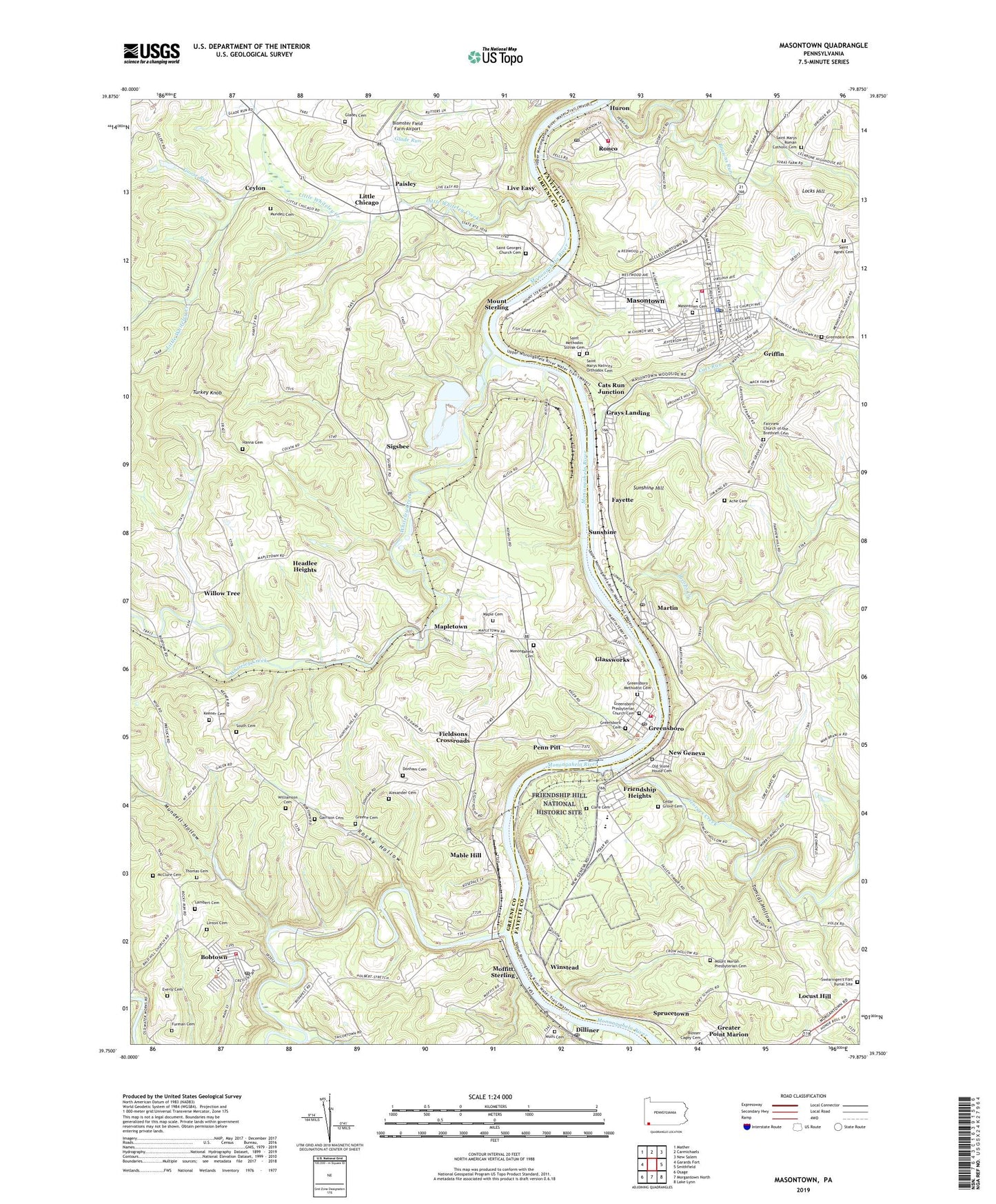
2023 topographic map quadrangle Masontown in the state of Pennsylvania. Scale: 1:24000. Based on the newly updated USGS 7.5' US Topo map series, this map is in the following counties: Greene, Fayette. The map contains contour data, water features, and other items you are used to seeing on USGS maps, but also has updated roads and other features. This is the next generation of topographic maps. Printed on high-quality waterproof paper with UV fade-resistant inks.
Quads adjacent to this one:
West: Garards Fort
Northwest: Mather
North: Carmichaels
Northeast: New Salem
East: Smithfield
South: Morgantown North
Southwest: Osage
This map covers the same area as the classic USGS quad with code o39079g8.
Contains the following named places: Ache Cemetery, Active Uellow Boy Pond, Albert Gallatin Senior High School, Alexander Cemetery, Atlantic, Big Tree, Blomster Field Farm Airport, Blosser Cagey Cemetery, Bobtown, Bobtown - Dunkard Township Volunteer Fire Department Company 17, Bobtown Census Designated Place, Bobtown Elementary School, Bobtown Post Office, Borough of Greensboro, Borough of Masontown, Browns Run, Cabbage Flats, Cagey School, Cats Run, Cats Run Junction, Cats Run Junction Station, Cedar Grove Cemetery, Ceylon, Clare Cemetery, Davistown, Dilliner, Dilliner Post Office, Donham Cemetery, Dora, Emergency Medical Services Southwest Carmichaels Station, Everly Cemetery, Fairview Church, Fairview Church of the Brethren Cemetery, Fallen Timbers Church, Fayette, Fayette Emergency Medical Services German, Fieldsons Crossroads, Friendship Heights, Friendship Hill, Friendship Hill Elementary School, Friendship Hill National Historic Site, Furman Cemetery, Gallatin, Gallatin Fuel Heliport, Garrison Cemetery, Geneva Siding, Georges Creek, Glades Cemetery, Glassworks, Goose Run, Grays Landing, Grays Landing Lock and Dam, Grays Landing Pool, Greater Point Marion, Greendale Cemetery, Greene Cemetery, Greensboro, Greensboro - Monongahela Township Volunteer Fire Department Company 63, Greensboro Cemetery, Greensboro Methodist Cemetery, Greensboro Post Office, Greensboro Presbyterian Church Cemetery, Greensburg Ferry, Griffin, Hanna Cemetery, Headlee Heights, Huron, Jacobs Creek, Keener Cemetery, Lambert Cemetery, Lardin, Lee Norse Number Five Heliport, Linton Cemetery, Little Chicago, Little Whiteley Creek, Live Easy, Locks Hill, Mable Hill, Maple Cemetery, Mapletown, Mapletown Census Designated Place, Martin, Martin Post Office, Masontown, Masontown Borough Police Department, Masontown Cemetery, Masontown Post Office, Masontown Volunteer Fire Department Station 25, McClure Cemetery, Mennonite Church, Moffitt Sterling, Monongahela Cemetery, Monongahela River Lock and Dam Seven, Monongahela River Pool Seven, Mount Moriah Presbyterian Cemetery, Mount Olive Church, Mount Sterling, Mundell Cemetery, Mundell Hollow, New Geneva, New Providence Church, Newtown, Old Stone House Cemetery, Paisley, Penn Pitt, Penn Pitt Elementary School, Poland Mines, Pond Four, Robena Slope Mine Dam, Robena Slope Mine Refuse Bank Dam, Robena Slurry Pond Number Six Dam, Rocks Works, Rocky Hollow, Ronco, Ronco Census Designated Place, Ronco Post Office, Ronco Volunteer Fire Department Station 49, Ross Ferry, Saint Agnes Cemetery, Saint Georges Church, Saint Georges Church Cemetery, Saint Marys Nativity Orthodox Cemetery, Saint Marys Roman Catholic Cemetery, Saint Methodos Slovak Cemetery, Saint Nicholas Church, Shordon Chapel, Sigsbee, South Cemetery, Sprucetown, Sugar Grove Church, Sugar Grove School, Sunshine, Sunshine Hill, Swearingen's Fort Burial Site, Thomas Cemetery, Tomcat Hollow, Township of Dunkard, Township of Monongahela, Turkey Knob, Union Church, War Branch, Whiteley Creek, Wiley, Williamson Cemetery, Willow Grove School, Willow Tree, Winstead, Wolfs Cemetery, ZIP Codes: 15315, 15334, 15460, 15461, 15467, 15474, 15476