MyTopo
Carmichaels Pennsylvania US Topo Map
Couldn't load pickup availability
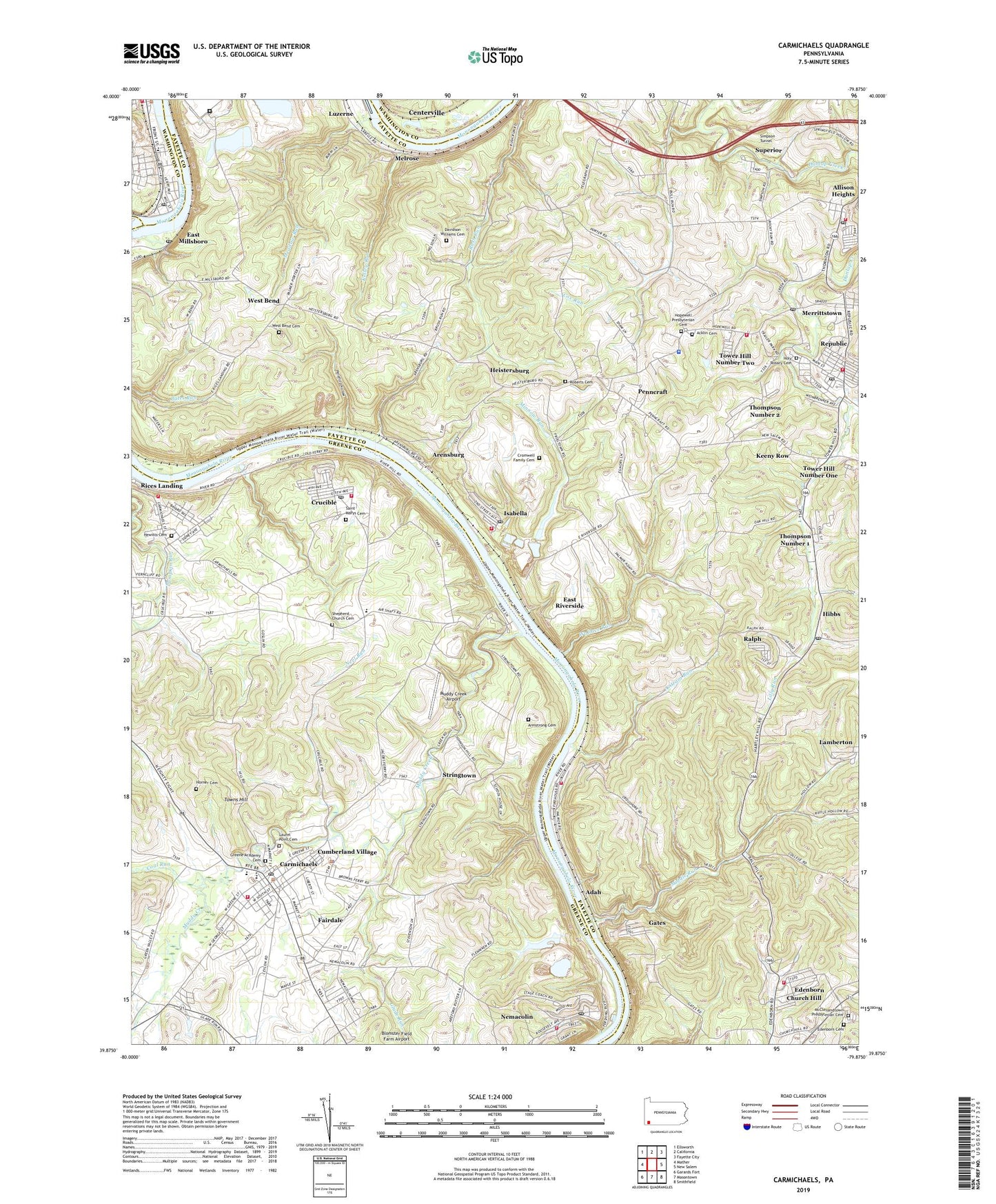
2023 topographic map quadrangle Carmichaels in the state of Pennsylvania. Scale: 1:24000. Based on the newly updated USGS 7.5' US Topo map series, this map is in the following counties: Fayette, Greene, Washington. The map contains contour data, water features, and other items you are used to seeing on USGS maps, but also has updated roads and other features. This is the next generation of topographic maps. Printed on high-quality waterproof paper with UV fade-resistant inks.
Quads adjacent to this one:
West: Mather
Northwest: Ellsworth
North: California
Northeast: Fayette City
East: New Salem
Southeast: Smithfield
South: Masontown
Southwest: Garards Fort
This map covers the same area as the classic USGS quad with code o39079h8.
Contains the following named places: Acklin Cemetery, Adah, Adah Volunteer Fire Department Station 1, Allison Heights, Allison Number 2 Volunteer Fire Department Station 3, Allison Post Office, Antram, Antram Run, Arensburg, Armstrong Cemetery, Baily Airport, Big Meadow Run Station, Borough of Carmichaels, Borough of Rices Landing, Broken Tee Golf Course, Carmichaels, Carmichaels - Cumberland Township Volunteer Fire Department Company 65, Carmichaels Area Junior and Senior High School, Carmichaels Post Office, Central Elementary School, Christopher School, Church Hill, Coal Run, Cox Run, Cromwell Family Cemetery, Crucible, Crucible Census Designated Place, Crucible Elementary School, Crucible Post Office, Crucible Volunteer Fire Department Company 64, Cumberland Township Police Department, Cumberland Village, Davidson Williams Cemetery, Dunlap, East Bethlehem Township Volunteer Fire Department Station 15, East Millsboro, East Millsboro Post Office, East Riverside, East Riverside Church, Edenborn, Edenborn Cemetery, Edenborn Census Designated Place, Edenborn Volunteer Fire Company Station 13, Fairdale, Fairdale Census Designated Place, Fayette Emergency Medical Services Redstone Station, Gates, Glade Run, Greene Academy Cemetery, Haines School, Heistersburg, Hereford Hollow, Hewitts Cemetery, Hibbs, Hibbs Post Office, Holy Rosary Cemetery, Hopewell Church, Hopewell Presbyterian Cemetery, Horner Cemetery, Isabella, Isabella Post Office, Isabella Volunteer Fire Department Station 22, Keeny Row, Kelley Run, Labelle Slurry Pond Three Dam, Lamberton, Laurel Point Cemetery, Lilly Run, Luzerne, Luzerne Central School, Maxwell Lock and Dam, McClellandtown Presbyterian Cemetery, Meadow Run, Melrose, Merrittstown, Merrittstown Post Office, Middle Run, Millsboro, Millsboro Post Office, Minnow Run, Muddy Creek, Muddy Creek Airport, Neel Run, Neil Corner, Nemacolin, Nemacolin Census Designated Place, Nemacolin Elementary School, Nemacolin Post Office, Nemacolin Volunteer Fire Department Company 67, Palmer, Pegs Run, Penncraft, Pumpkin Run, Ralph, Redstone Middle School, Republic, Republic Census Designated Place, Republic Post Office, Republic Volunteer Fire Company Station 34, Rices Landing, Rices Landing Volunteer Fire Department Company 66, Roberts Cemetery, Rush Run School, Saint Marys Cemetery, Sara, Shepherd Church Cemetery, Simpson Tunnel, State Correctional Institution Fayette, State Game Lands Number 238, Stringtown, Superior, Tenmile Creek, Thompson Number 1, Thompson Number 2, Tower Hill Number 2 Volunteer Fire Department Station 39, Tower Hill Number One, Tower Hill Number Two, Towns Hill, Township of Cumberland, Township of Luzerne, Wallace Run, West Bend, West Bend Cemetery, West Bend Church, West Bend School, ZIP Codes: 15320, 15325, 15348, 15351, 15357, 15410, 15433, 15443, 15447, 15463, 15475