MyTopo
Wagontown Pennsylvania US Topo Map
Couldn't load pickup availability
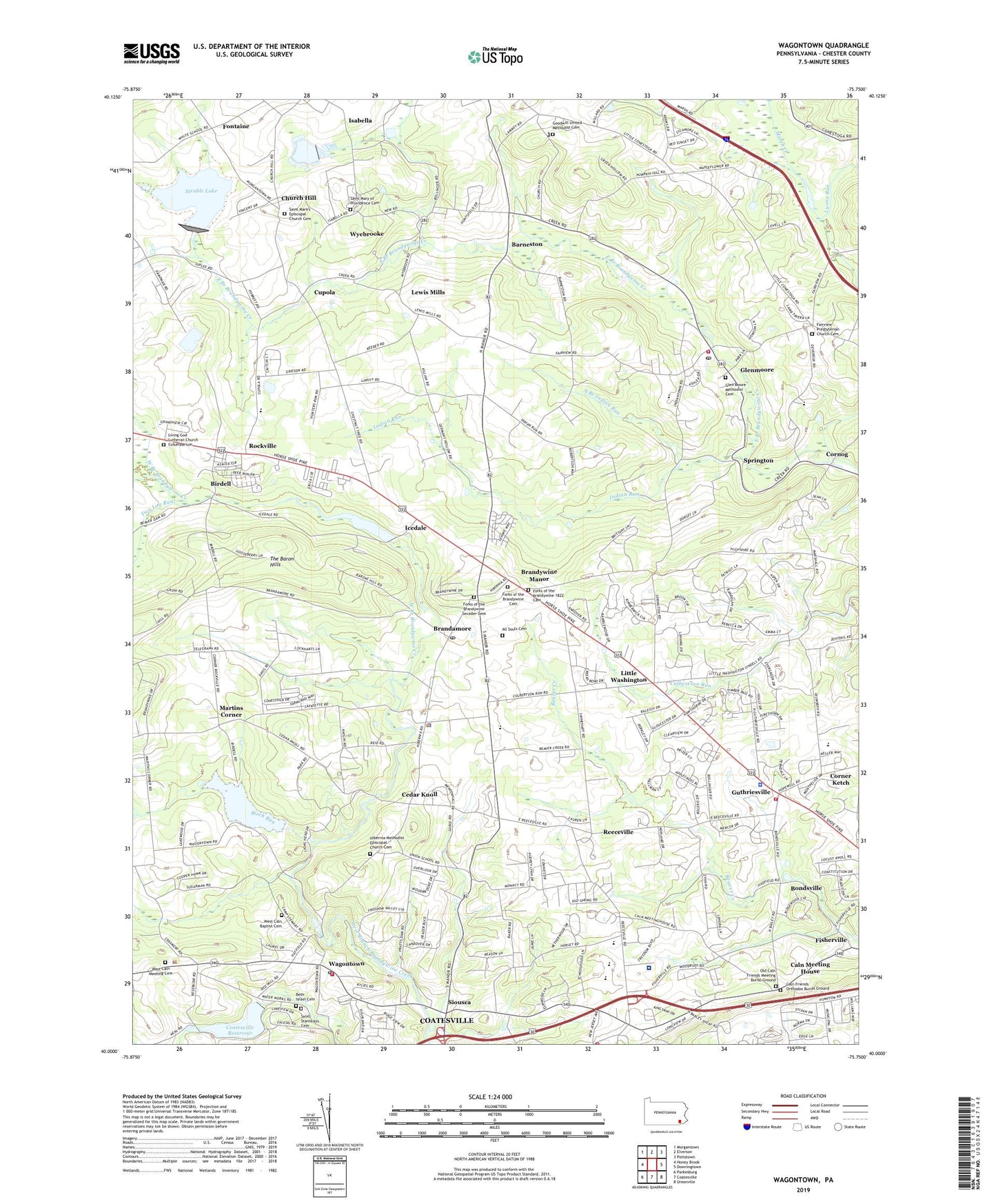
2019 topographic map quadrangle Wagontown in the state of Pennsylvania. Scale: 1:24000. Based on the newly updated USGS 7.5' US Topo map series, this map is in the following counties: Chester. The map contains contour data, water features, and other items you are used to seeing on USGS maps, but also has updated roads and other features. This is the next generation of topographic maps. Printed on high-quality waterproof paper with UV fade-resistant inks.
Quads adjacent to this one:
West: Honey Brook
Northwest: Morgantown
North: Elverson
Northeast: Pottstown
East: Downingtown
Southeast: Unionville
South: Coatesville
Southwest: Parkesburg
Contains the following named places: All Souls Cemetery, Barneston, Barnestown Post Office, Beiler Airport, Beth Israel Cemetery, Birch Run, Birdell, Bondsville, Bondsville Dam, Brandamore, Brandamore Dam, Brandamore Post Office, Brandywine Facility, Brandywine Hospital, Brandywine Manor, Brandywine Wallace Elementary School, Caln Friends Orthodox Burial Ground, Caln Meeting House, Camp Indian Run, Cedar Knoll, Church Hill, Coatesville Country Club, Coatesville Dam, Coatesville Department of Veterans Affairs Fire Department Station 76, Coatesville Reservoir, Coatesville VA Medical Center, Cornog, Cornog Station, Cupola, Dampman, Devereux School, East Brandywine Fire Company Station 49, East Brandywine Township Police Department, East Brandywine Township Police Station, Fairview Church, Fairview Presbyterian Church Cemetery, Fisherville, Fontaine, Forks of the Brandywine 1822 Cemetery, Forks of the Brandywine Cemetery, Forks of the Brandywine Seceder Cemetery, Franklin School, Glen Moore Fire Company Station 48, Glen Moore Methodist Cemetery, Glenmoore, Glenmoore Census Designated Place, Glenmoore Post Office, Goodwill Church, Goodwill United Methodist Cemetery, Guthriesville, Hatfield House, Hibernia Church, Hibernia Mansion, Hibernia Methodist Episcopal Church Cemetery, Icedale, Icedale Lake, Indian Run, Ingleside Golf Course, Isabella, Isabella Post Office, Lewis Mills, Lincoln School, Little Washington, Living God Lutheran Church Columbarium, Lyons Run, Martins Corner, Martins Corner Volunteer Fire Company Station 34, North Branch Indian Run, North Brandywine Middle School, Norwood, Old Caln Friends Meeting Burial Ground, Old Mill Bible Conference, Peter J Camiel Service Plaza, Reeceville, Reeceville Elementary School, Robert G Struble Dam, Rock Run Dam, Rocklyn, Rockville, Saint Marks Church, Saint Mark's Episcopal Church Cemetery, Saint Mary of Providence Cemetery, Saint Marys of Providence, Saint Stanislaus Cemetery, Siousca, Springton, Springton Station, Struble Lake, Struble Lake Recreation Area Boat Ramp, Township of Caln, Township of East Brandywine, Township of Wallace, Township of West Brandywine, Township of West Nantmeal, Two Log Run, Wagontown, Wagontown Dam, Wagontown Post Office, Wagontown Volunteer Fire Company Station 35, Wallace Township Building, Wallace Township Police Station, WCOJ-AM (Coatesville), West Brandywine Township Building, West Brandywine Township Police Department, West Brandywine Township Police Station, West Caln Baptist Cemetery, West Caln Meeting Cemetery, West Caln Township Building, West Caln Township Police Department, West Caln Township Police Station, Wyebrooke, ZIP Codes: 19316, 19343