MyTopo
Pottstown Pennsylvania US Topo Map
Couldn't load pickup availability
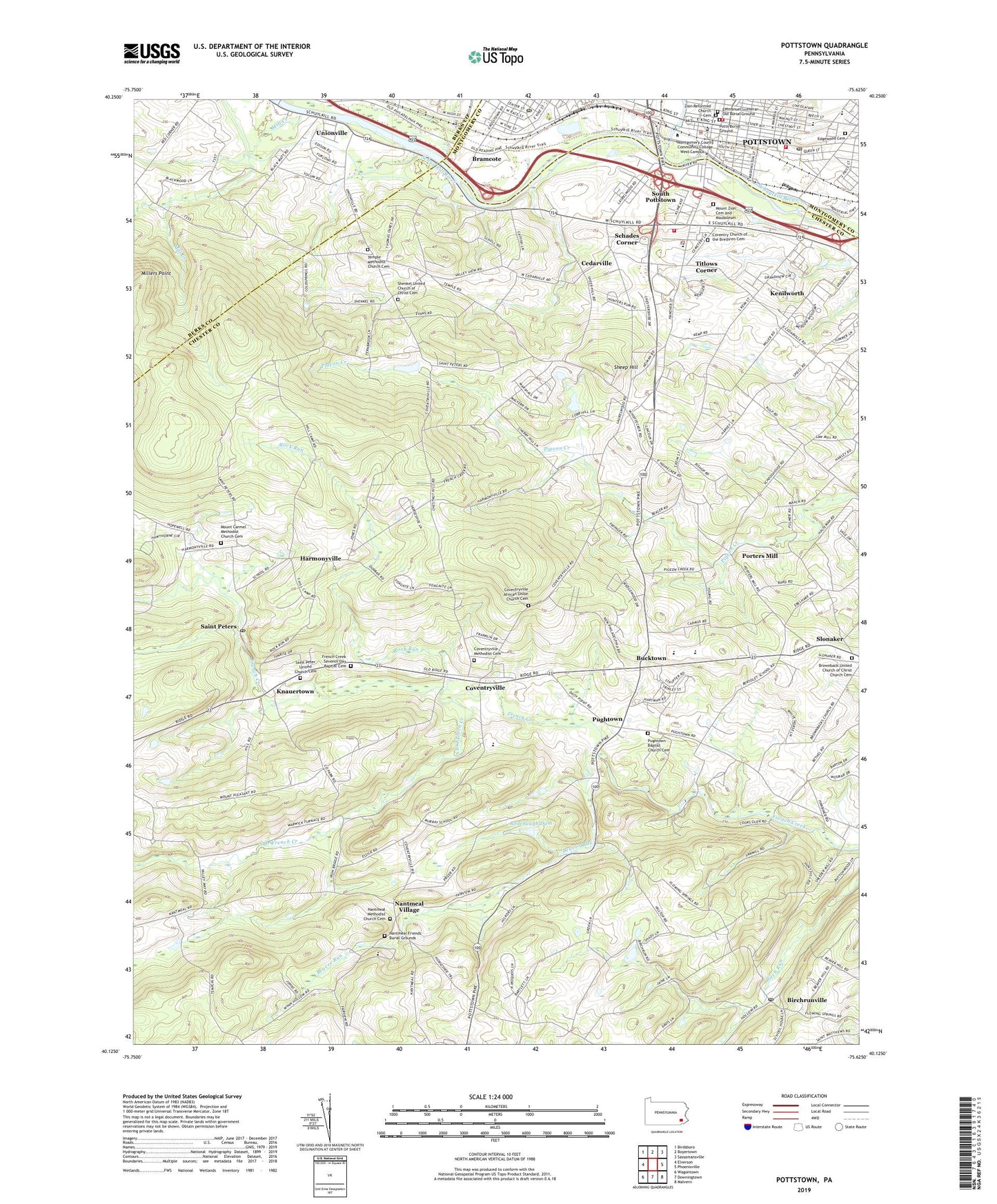
2023 topographic map quadrangle Pottstown in the state of Pennsylvania. Scale: 1:24000. Based on the newly updated USGS 7.5' US Topo map series, this map is in the following counties: Chester, Berks, Montgomery. The map contains contour data, water features, and other items you are used to seeing on USGS maps, but also has updated roads and other features. This is the next generation of topographic maps. Printed on high-quality waterproof paper with UV fade-resistant inks.
Quads adjacent to this one:
West: Elverson
Northwest: Birdsboro
North: Boyertown
Northeast: Sassamansville
East: Phoenixville
Southeast: Malvern
South: Downingtown
Southwest: Wagontown
This map covers the same area as the classic USGS quad with code o40075b6.
Contains the following named places: Beaver Run, Bentley Airport, Birchrunville, Birchrunville Post Office, Blackwood Golf Course, Bramcote, Brownback United Church of Christ Church Cemetery, Bucktown, Buzzard Trail, Camp Fern Brook, Camp Innabah, Camp Innabah Dam, Camp Sankanac, Cedarville, Chestnut Hill, Cold Spring Park, Coventry Church of the Brethren Cemetery, Coventry Post Office, Coventryville, Coventryville African Union Church Cemetery, Coventryville Methodist Cemetery, E L Gruber Airport, Edgewood Cemetery, Emmanuel Lutheran Old Burial Ground, French Creek Seventh Day Baptist Cemetery, French Creek Valley Elementary School, Harmonyville, Hill School, Jefferson School, Kenilworth, Kenilworth Census Designated Place, Kenilworth Park, Kimberton Fish and Game Association, Knauertown, Leaf Creek, Manatawny Creek, Manatawny Park, Mill Creek, Millers Point, Mount Carmel Methodist Church Cemetery, Mount Zion Cemetery and Mausoleum, Nantmeal Friends Burial Grounds, Nantmeal Methodist Church Cemetery, Nantmeal Village, Neimans Pond, Norco Fire Company Station 64, North Coventry Elementary School, North Coventry Township Police Department, Owen J Roberts High School, Owen J Roberts Middle School, Park Dam, Porters Mill, Potts Burial Ground, Pottstown, Pottstown Borough Police Department, Pottstown Fire Department - Empire Hook and Ladder Company, Pottstown Fire Department - Goodwill Steam Fire Engine Company 1, Pottstown Fire Department - Philadelphia Steam Fire Company - Station 69 - B, Pottstown Landing, Pottstown Post Office, Pughtown, Pughtown Baptist Church Cemetery, Pughtown Census Designated Place, Pughtown Post Office, Raccoon Trail, Rock Run, Rodebaugh Dam, Saint Clair School, Saint Peter United Church Cemetery, Saint Peters, Saint Peters Church, Saint Peters Post Office, Schades Corner, Sheep Hill, Shenkel United Church of Christ, Shenkel United Church of Christ Cemetery, Slonaker, South Branch French Creek, South Pottstown, South Pottstown Census Designated Place, State Game Land Number 43, Stowe Post Office, Temple Church, Temple Methodist Church Cemetery, Titlows Corner, Township of East Nantmeal, Township of North Coventry, Township of South Coventry, Township of West Pottsgrove, Township of West Vincent, Unionville, Warwick Elementary School, Washington School, Zion Reformed Church Cemetery, ZIP Code: 19465