MyTopo
Elverson Pennsylvania US Topo Map
Couldn't load pickup availability
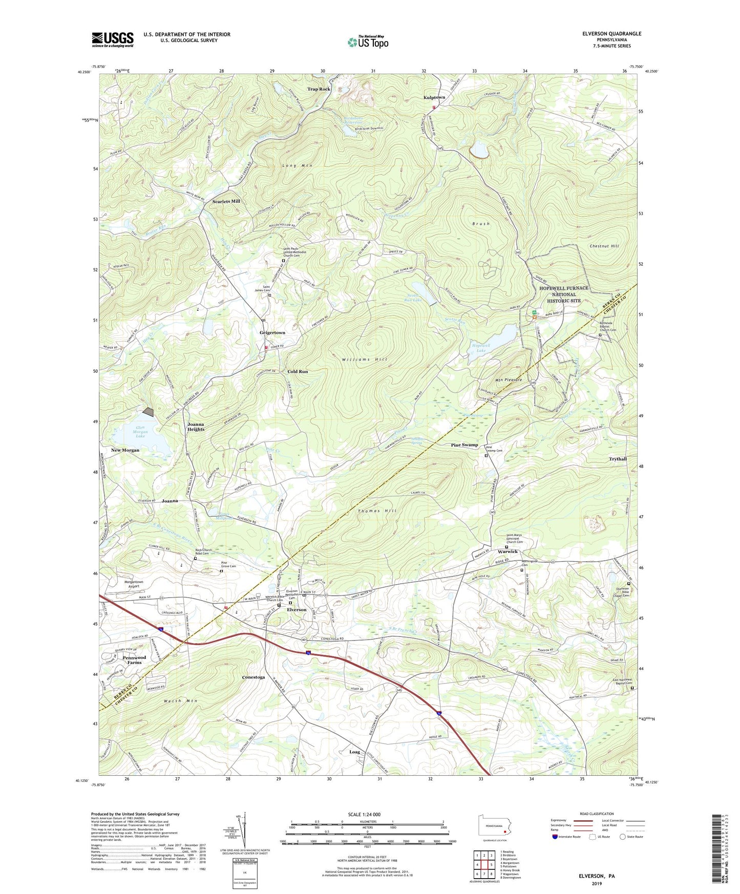
2023 topographic map quadrangle Elverson in the state of Pennsylvania. Scale: 1:24000. Based on the newly updated USGS 7.5' US Topo map series, this map is in the following counties: Berks, Chester, Lancaster. The map contains contour data, water features, and other items you are used to seeing on USGS maps, but also has updated roads and other features. This is the next generation of topographic maps. Printed on high-quality waterproof paper with UV fade-resistant inks.
Quads adjacent to this one:
West: Morgantown
Northwest: Reading
North: Birdsboro
Northeast: Boyertown
East: Pottstown
Southeast: Downingtown
South: Wagontown
Southwest: Honey Brook
This map covers the same area as the classic USGS quad with code o40075b7.
Contains the following named places: Beaver Run, Bethesda Baptist Church Cemetery, Bethesda Church, Bethlehem Mines Corporation Dam, Birdsboro - Union Fire Department Station 7 - 2, Birdsboro Quarry, Birdsboro Reservoir, Birdsboro Reservoir Dam, Boone Trail, Borough of Elverson, Briarwood, Brush, Camp Clewell, Central School, Chestnut Hill, Cold Run, Colliers Trail, Conestoga, East Nantmeal Baptist Cemetery, East Nantmeal Church, Ebenezer Bible Chapel Cemetery, Ebenezer Church, Elverson, Elverson Methodist Cemetery, Elverson Post Office, French Creek Amphitheatre, French Creek Campground, French Creek State Park, Friendship Fire Company 1 Geigertown Station 24, Friendship Fire Company Baseball Field, Geigertown, Geigertown Post Office, Geigertown Station, Glen Morgan Lake, Grace Mine Tailings Dam, Grange Hall, Hampton Dam, Hause School, Hay Creek Watershed, High Point Baptist Academy, High Point Baptist Chapel, High Point Camp, High Point Camp Pool, Hopewell Dam, Hopewell Fire Tower, Hopewell Furnace, Hopewell Furnace National Historic Site, Hopewell Furnace National Historic Site Visitor's Center, Hopewell Lake, Indian Run Dam, Joanna, Joanna Heights, Jones Millpond, Kalmia Trail, Kenneys, Kulptown, Lenade Trail, Livingood Park, Loag, Long Mountain, Marsh, Mill Creek Trail, Morgantown Airport, Morgantown Community Church, Morgantown Crossings, Morgantown Industrial Park, Morningside Cemetery, Mountain Pleasure, Northgate Business Center, Pennwood Farms, Pine Creek, Pine Grove Cemetery, Pine Swamp, Pine Swamp Cemetery, Pine Swamp Natural Area, Ridge Trail, Robeson Elementary Center, Rock Church, Rock Church Road Cemetery, Saint James Cemetery, Saint James Church, Saint Marys Episcopal Church Cemetery, Saint Pauls Church, Saint Pauls United Methodist Church Cemetery, Scarlets Mill, Scotts Run, Scotts Run Dam, Scotts Run Lake, Six Penny Trail, Sixpenny Dam, State Game Lands Number 43, Stolzfus Spring, Thomas Hill, Thousand Oaks Corporate Center, Township of Robeson, Township of Union, Township of Warwick, Trap Rock, Trythall, Turtle Trail, Twin Valley Elementary Center, Twin Valley Fire Department Station 69, Twin Valley Middle School, Union Township Municipal Building, Warwick, Warwick Bible Church Cemetery, Williams Hill, ZIP Codes: 19520, 19523