MyTopo
West York Pennsylvania US Topo Map
Couldn't load pickup availability
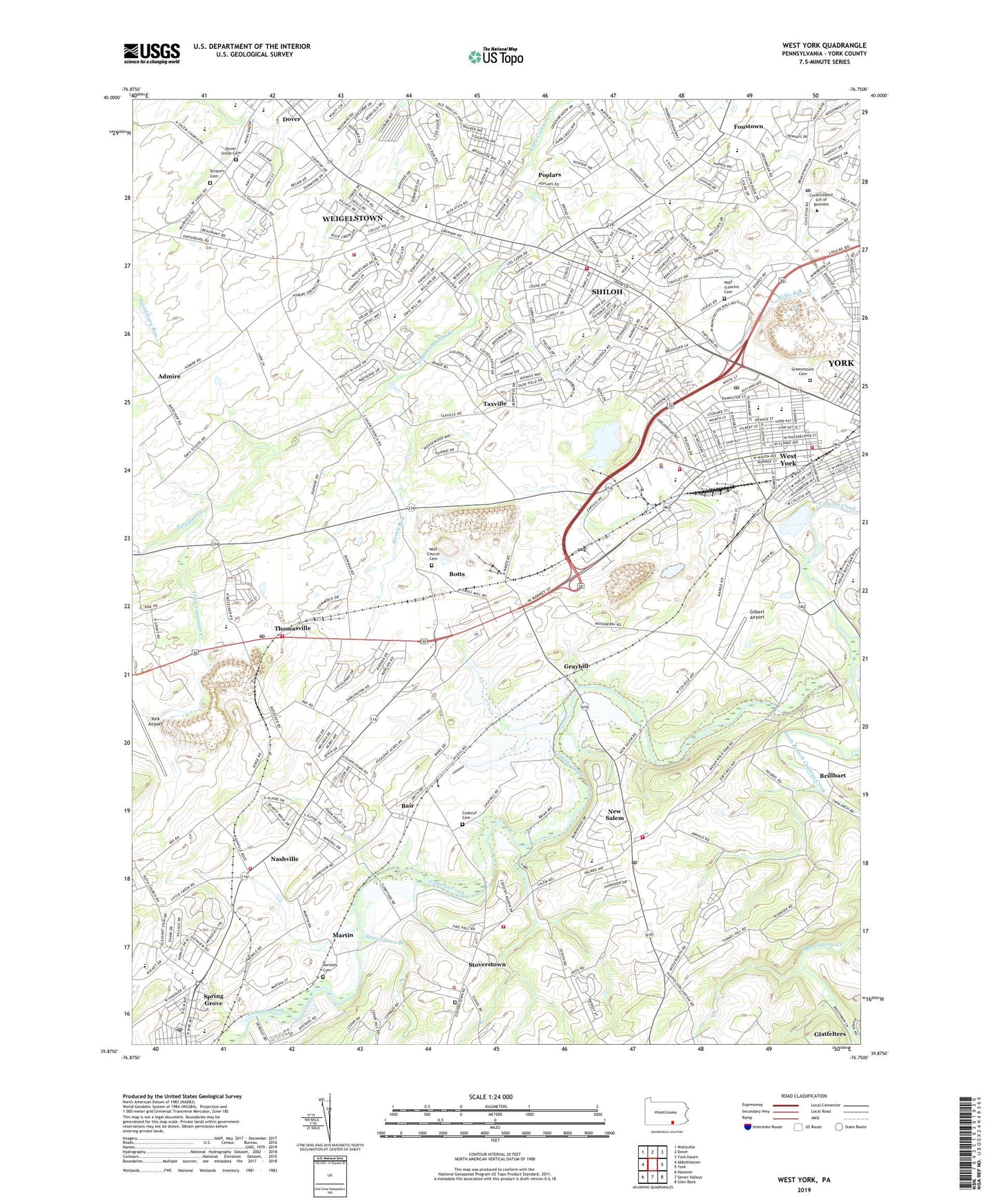
2019 topographic map quadrangle West York in the state of Pennsylvania. Scale: 1:24000. Based on the newly updated USGS 7.5' US Topo map series, this map is in the following counties: York. The map contains contour data, water features, and other items you are used to seeing on USGS maps, but also has updated roads and other features. This is the next generation of topographic maps. Printed on high-quality waterproof paper with UV fade-resistant inks.
Quads adjacent to this one:
West: Abbottstown
Northwest: Wellsville
North: Dover
Northeast: York Haven
East: York
Southeast: Glen Rock
South: Seven Valleys
Southwest: Hanover
Contains the following named places: Admire, Bair, Bair Codorus Mennonite Cemetery, Borough of New Salem, Borough of Spring Grove, Borough of West York, Bott Cemetery, Botts, Botts Station, Boyer School, Brillhart, Campbell Estates, Cherry Grove School, Christian School of York, Church of the Open Door, Delco Plaza Shopping Center, Dover Area Community Library, Dover Township Volunteer Fire Department Station 9, Dover Union Cemetery, Emig School, Fairway, Fireside Park, Foustown, Gilbert Airport, Glatfelter Memorial Library, Grand View Golf Course, Graybill, Greenbriar, Greenmount Cemetery, HealthSouth Rehabilitation Hospital of York, Heindel Elementary School, Hershey Burial Grounds, Hoke School, Holly Heights, Honey Run, Lincoln Stone Quarry, Lincolnway Elementary School, Lincolnway Fire Company Station 5, Little Creek Golf Course, Louck School, Loucks Cemetery, Martin, Mays Church, Nashville, Nashville Volunteer Fire Company Station 11, New Salem, New Salem Elementary School, North Codorus Township Fire Company Station 12, Paradise Creek, Penroc Quarry, Petre Farm, Poplars, Roosevelt Avenue Quarry, Saint Paul's Lutheran Church Cemetery, Saint Pauls Union Church, Salem Church, Salem Union Cemetery, Shelly School, Shiloh, Shiloh Census Designated Place, Shiloh Fire Company Station 2, Smith High School, Smyser Elementary School, South Branch Codorus Creek, Sprenkel School, Spring Grove Post Office, Springdale School, Stoverstown, Stoverstown Branch, Stump Acres Dairy, Taxville, Taxville Church, Thomasville, Thomasville Fire Company Station 3, Thomasville Post Office, Township of West Manchester, Two Guys Shopping Center, Weigelstown, Weigelstown Census Designated Place, West Manchester Consolidated School, West Manchester Township Fire and Emergency Services, West Manchester Township Police Department, West York, West York Ambulance, West York Borough - Police Department, West York Carrier Annex, West York Fire Department Station 1 Headquarters, West York Fire Department Station Number 1, West York Junior High School, West York Post Office, West York Senior High School, William Penn School, Wilson School, WOYK-AM (York), YBP Heliport, York Dam, York Indian Rock Dam, York New Salem Fire and Rescue Company Station 8, York New Salem Post Office, York Quarry, Yorktowne Golf Club, Zion United Methodist Church, ZIP Codes: 17371, 17408