MyTopo
Hanover Pennsylvania US Topo Map
Couldn't load pickup availability
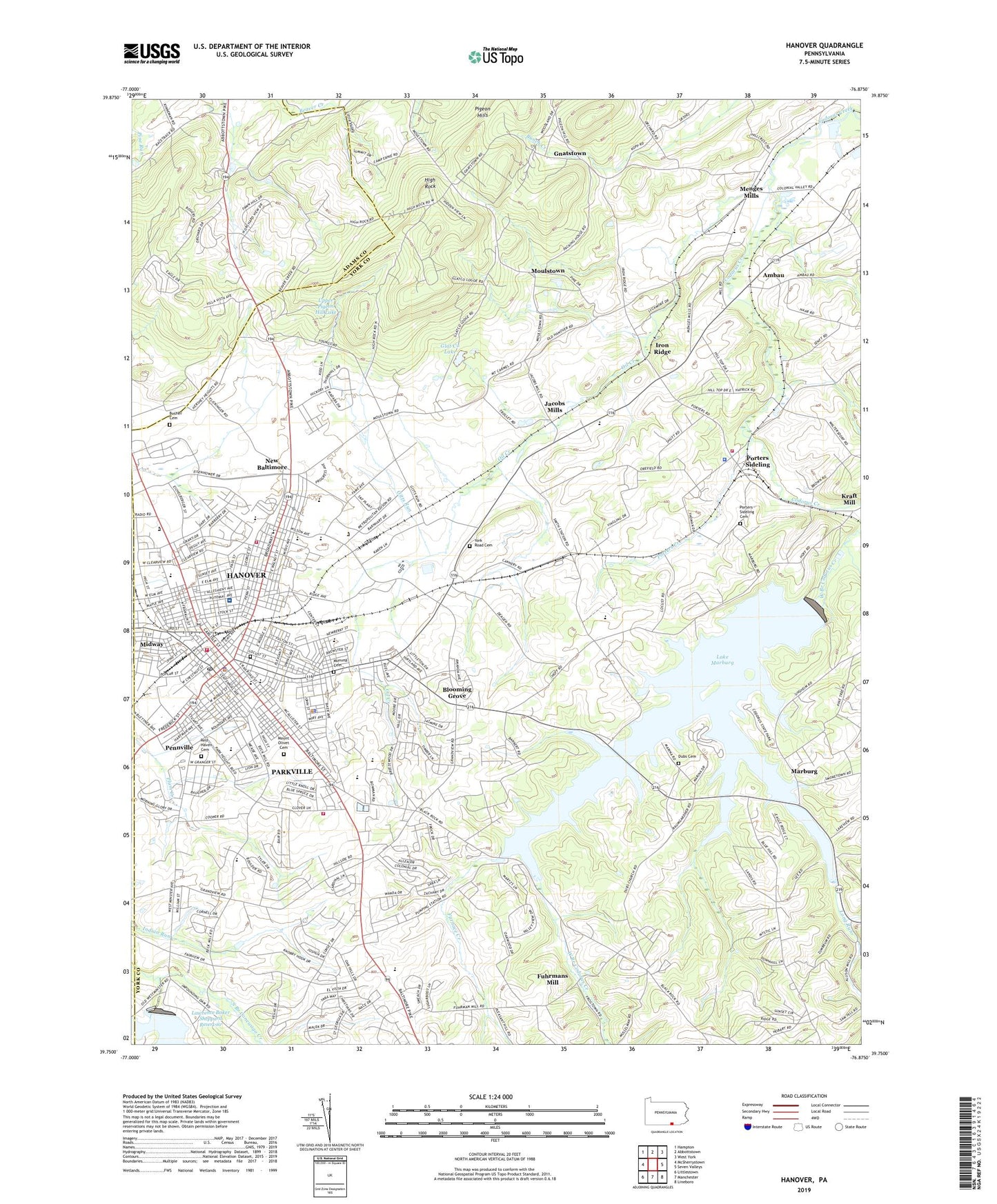
2023 topographic map quadrangle Hanover in the state of Pennsylvania. Scale: 1:24000. Based on the newly updated USGS 7.5' US Topo map series, this map is in the following counties: York, Adams. The map contains contour data, water features, and other items you are used to seeing on USGS maps, but also has updated roads and other features. This is the next generation of topographic maps. Printed on high-quality waterproof paper with UV fade-resistant inks.
Quads adjacent to this one:
West: McSherrystown
Northwest: Hampton
North: Abbottstown
Northeast: West York
East: Seven Valleys
Southeast: Lineboro
South: Manchester
Southwest: Littlestown
This map covers the same area as the classic USGS quad with code o39076g8.
Contains the following named places: Ambau, Bange Farms, Bears School, Beaver Creek Church, Beaver Creek School, Bethel Church, Blooming Grove, Borough of Hanover, Brookside School, Bucher Cemetery, Center School, Center Street School, Codorus State Park, Devener Airport, Dubs Cemetery, Dubs Picnic Grove, Erichleburg High School, Fairview School, Fellowship Camp Grove, Four Square Church, Fuhrmans Mill, Furnace Creek, Gerbers Church, Gitts Run, Glat Co Lake, Gnatstown, Grangeville Fire Company, Hanover, Hanover Area Fire and Rescue - Wirt Park Station, Hanover Borough Police Department, Hanover Fire Company Co 46 Clearview Station, Hanover Post Office, Hanover Street School, Heidelberg School, High Rock, High Street Grade School, Hoff School, Iron Ridge, Ironore P O, Jacobs Mills, Kraft Mill, Krentler School, Lake Marburg, Lake Marburg Dam, Lawrence Baker Sheppard Dam, Lincoln Speedway, Lischy Church, Little Valley, Long Arm Creek, Long Run, Marburg, Menges Mills, Miller School, Moses Mummert School, Moulstown, Mount Carmel School, Mount Olivet Cemetery, Mumma Cemetery, Myers School, Nace School, New Baltimore, North Hanover Mall, Oak View Church, Oil Creek, Old Reformed Graveyard, Parkville, Parkville Census Designated Place, Penn Grove, Penn Grove Bible Center, Penn Grove School, Penn Street School, Penn Township Police Department, Penn Township Volunteer Emergency Services Station 1 - 49 Headquarters, Penn Township Volunteer Emergency Services Station 2 - 49, Pennville, Pennville Census Designated Place, Pigeon Hills, Porters Cemetery, Porters Community Fire Company Station 53, Porters Creek, Porters Sideling, Porters Station, Rest Haven Cemetery, Saint Paul Church, Smiths Station, South Hills Golf Course, Southwestern Regional Police Department, Staffers School, State Game Propagation Area, Township of Berwick, Township of Heidelberg, Township of Penn, University of Pittsburgh Medical Center Pinnacle Hanover Hospital, Upper Pigeon Hill Dam, Upper Pigeon Hill Lake, Walnut Grove School, West Branch Codorus Creek, Wildasin Chapel, Wirt Park, WYCR-FM (York-Hanover), York Road, York Road Cemetery, Zumbrum School, ZIP Code: 17331