MyTopo
Williamsburg Pennsylvania US Topo Map
Couldn't load pickup availability
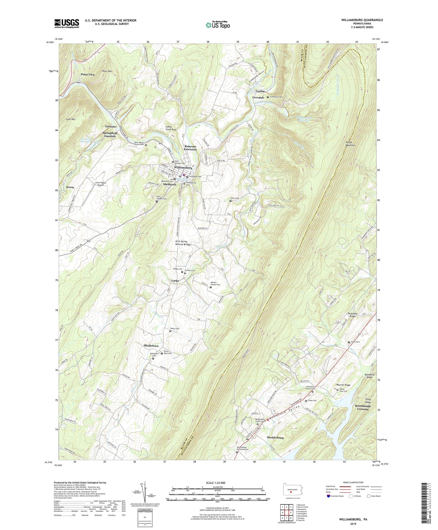
2019 topographic map quadrangle Williamsburg in the state of Pennsylvania. Scale: 1:24000. Based on the newly updated USGS 7.5' US Topo map series, this map is in the following counties: Blair, Huntingdon. The map contains contour data, water features, and other items you are used to seeing on USGS maps, but also has updated roads and other features. This is the next generation of topographic maps. Printed on high-quality waterproof paper with UV fade-resistant inks.
Quads adjacent to this one:
West: Frankstown
Northwest: Bellwood
North: Spruce Creek
Northeast: Alexandria
East: Huntingdon
Southeast: Cassville
South: Entriken
Southwest: Martinsburg
Contains the following named places: Arch Spring Natural Bridge, Big Springs, Borough of Marklesburg, Borough of Williamsburg, Bosler Cemetery, Bowers Family Cemetery, Brumbaugh Crossing, Brumbaugh Historical House, Carlim, Clover Creek, Cove Forge, Cove Forge Census Designated Place, Cove Forge Church, Cove Valley Airport, Covedale, Fairview Church, Fisherville, Fisherville Census Designated Place, Frank Cemetery, Franklin Forge, Franklin Forge Census Designated Place, Ganister, Ganister Blue Hole, Ganister Census Designated Place, Grove Cemetery, Hesston Speedway, Hitch Boat Launch, Indian Chief Rock, James Creek Church, James Creek Post Office, Larke, Larke Census Designated Place, Loop Lookout Tower, Marklesburg, Marklesburg Reformed Cemetery, Marklesburg Union Cemetery, Marklesburg Volunteer Fire Company Station 3, Martinsburg Sportsmens Lodge, Old Biddle Farm Cemetery, Old Methodist Cemetery, Old Stone Church Cemetery, Piney Creek, Point View, Point View Census Designated Place, Presbyterian Cemetery, Redstone Ridge, Robeson Extension, Robeson Extension Census Designated Place, Saint Clair, Saint Clair Census Designated Place, Saint Johns Church, Saint John's Evangelical Lutheran Cemetery, Saint Joseph's Catholic Cemetery, Saint Josephs Cemetery, Saint Marys Church, Saint Mary's Church Cemetery, Saint Mathews Church, Schmucker Cemetery, Schmucker Run, Shelltown, Shelltown Census Designated Place, Shellytown, Shellytown Census Designated Place, Shellytown Fairview Cemetery, Short Mountain, Snare Run, Snively Cemetery, Sparr, Sparr Cemetery, Springfield Bridge, Springfield Junction, Stacy Knob, State Game Lands Number 118, Thompson Cemetery, Township of Woodbury, Township Run, Valley View Cemetery, Wertz, Williamsburg, Williamsburg Area Ambulance, Williamsburg Area Volunteer Fire Company Station 90, Williamsburg Police Department, Williamsburg Post Office, Williamsburg Reservoir, Williamsburg Sportsmens Park, Williamsburg Station Dam, Williamsburg Station Lake, Zion Church, ZIP Code: 16693