MyTopo
Voluntown Connecticut US Topo Map
Couldn't load pickup availability
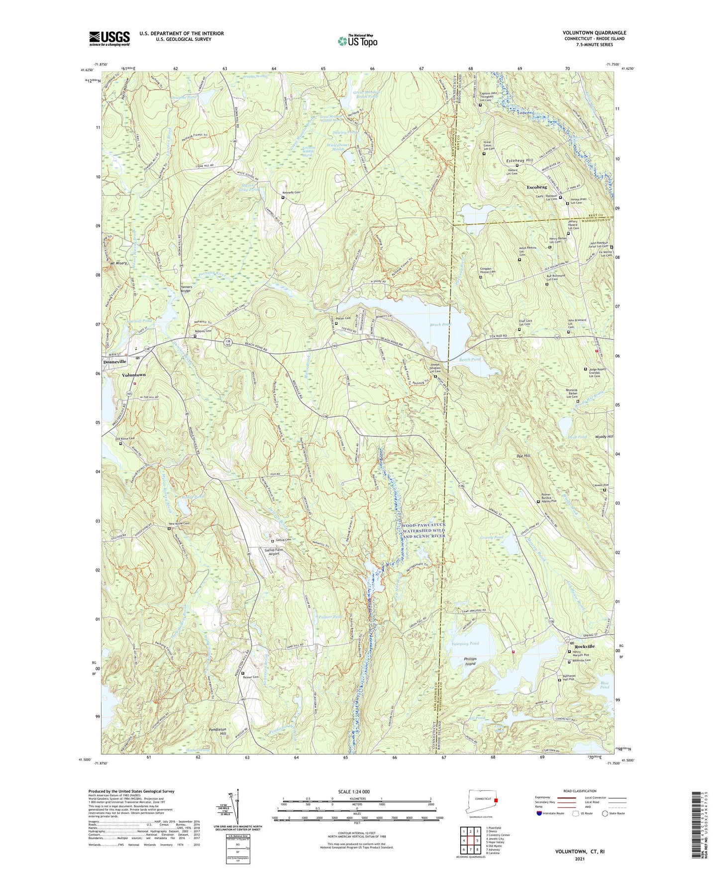
2024 topographic map quadrangle Voluntown in the states of Connecticut, Rhode Island. Scale: 1:24000. Based on the newly updated USGS 7.5' US Topo map series, this map is in the following counties: New London, Washington, Kent. The map contains contour data, water features, and other items you are used to seeing on USGS maps, but also has updated roads and other features. This is the next generation of topographic maps. Printed on high-quality waterproof paper with UV fade-resistant inks.
Quads adjacent to this one:
West: Jewett City
Northwest: Plainfield
North: Oneco
Northeast: Coventry Center
East: Hope Valley
Southeast: Carolina
South: Ashaway
Southwest: Old Mystic
Contains the following named places: Amasa Pratt Lot Cemetery, Amos Perkins Lot Cemetery, Ashville Pond, Ashville Pond Dam, Baptist Camp, Beach Pond, Beach Pond Dam, Beachdale, Beachdale Pond, Beachdale Pond Dam, Bliven Brook, Blue Pond, Captain John Tillinghast Lot Cemetery, Casey - Rathbun Lot Cemetery, Caswell Lot Cemetery, Dark Hollow Brook, Dawley Pond, Deep Pond, Denison Brook, Doaneville Pond, Douglas Pond, Douglas Pond Dam, Dye Hill, Ell Pond, Ellet Lock Lot Cemetery, Erickson Wildlife Marsh, Escoheag, Escoheag Hill, Exeter Fire Department 2 Station 3, First Baptist Church, Gallup Cemetery, Gallup Farm Airport, Grassy Pond, Great Meadow Brook, Great Meadow Brook Pond, Great Meadow Brook Pond Dam, Great Meadow Wildlife Marsh, Green Fall Pond, Green Fall Pond Dam, Hazard Lot Cemetery, Hell Hollow, Henry Barber Lot Cemetery, Henry Maryott Plot, Hodge Pond, Hope Valley Wyoming Fire District Station 3, Isreal Gates Lot Cemetery, John Brainard Lot Cemetery, Joseph Douglass Lot Cemetery, Judge Robert Crandall Lot Cemetery, Kelley Brook, Kennedy Cemetery, Koistenen Brook, Log House Brook, Long Pond, Long Pond Dam, Lowden Brook, Mason-Gray Pond, Mount Misery, Mount Misery Brook, Myron Kinney Brook, Narragansett Trail, Nathaniel Hall Plot, New Kinne Cemetery, Old Kinne Cemetery, Palmer - Burdick - Appley Lot Cemetery, Palmer Cemetery, Palmer Pond, Peg Mill Brook, Pendleton Hill, Phillips Island, Potter Cemetery, Reynolds Barber Lot Cemetery, Robbins Cemetery, Rockville, Rockville Cemetery, Rockville Management and Public Fishing Area, Rockville Post Office, Rockville Seventh Day Baptist Church, Rue Richmond Lot Cemetery, Saint Thomas-Saint Anns Parish Center, Sawmill Pond, Sawmill Pond Dam, Stepstone Falls, Tanners Bridge, Tippecansett Pond, Town of Voluntown, Upper Deep Hole, Voluntown, Voluntown Baptist Church, Voluntown Elementary School, Voluntown Fire Department Station 53, Voluntown Post Office, Voluntown Public Library, WERI-FM (Westerly), Wiclcabouet Marsh, Wiclcabouet Marsh Dam, Wincheck Pond, Wincheck Pond Dam, Wood River Preschool, Wylie School, Yawgoog Pond, Yawgoog Pond Dam, ZIP Codes: 02873, 06384