MyTopo
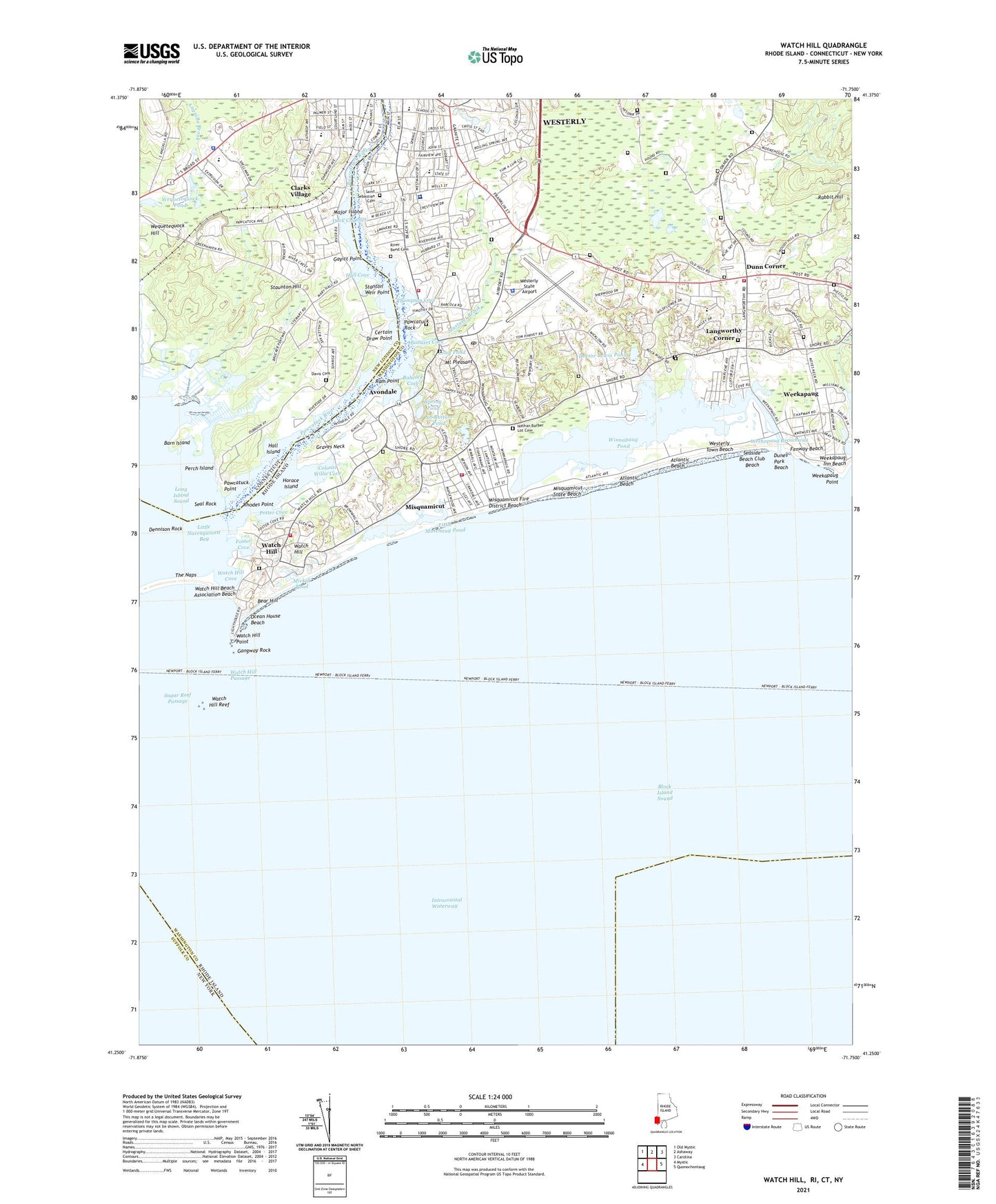
Watch Hill Rhode Island US Topo Map
Couldn't load pickup availability
2024 topographic map quadrangle Watch Hill in the states of Connecticut, Rhode Island. Scale: 1:24000. Based on the newly updated USGS 7.5' US Topo map series, this map is in the following counties: Washington, New London, Suffolk. The map contains contour data, water features, and other items you are used to seeing on USGS maps, but also has updated roads and other features. This is the next generation of topographic maps. Printed on high-quality waterproof paper with UV fade-resistant inks.
Quads adjacent to this one:
West: Mystic
Northwest: Old Mystic
North: Ashaway
Northeast: Carolina
East: Quonochontaug
This map covers the same area as the classic USGS quad with code o41071c7.
Contains the following named places: Anguilla Brook, Atlantic Beach, Atlantic Beach Amusement Park, Avondale, Babcock Cove, Babcock Middle School, Barn Island, Barn Island Hunting Area, Bear Hill, Certain Draw Point, Christadelphian Ecclesia Church, Clarks Village, Colonel Willie Cove, Davis Cemetery, Dennison Rock, Doctor Lewis Pond, Duck Channel, Dunes Park Beach, Dunn Corner, Dunns Corner Fire Department Station 1, Dunns Corner School, Dunns Corners Church Preschool, Dunns Corners Community Church, Evangelical Temple Full Gospel Church, Family Christian Center, Fenway Beach, Flying Horse Carousel, Foster Cove, Franklin Shopping Plaza Shopping Center, Gangway Rock, Gayitt Point, Granite Hills Shopping Center, Granite Street Shopping Center, Graves Neck, Hall Cove, Hall Island, Horace Island, Langworthy Corner, Langworthy Field, Little Maschaug Pond, Little Narragansett Bay, Little People of Westerly Day Care Center, Long Pond, Main Street Historic District, Major Island, Maschaug Pond, Mastuxet Brook, Mastuxet Cove, Mickill Pond, Misquamicut, Misquamicut Census Designated Place, Misquamicut Club Golf Course, Misquamicut Fire Department, Misquamicut Fire District Beach, Misquamicut State Beach, Mount Pleasant, Napatree Beach, Nathan Barber Lot Cemetery, Ninigret Statue, No Bottom Pond, Ocean House Beach, Pawcatuck Middle School, Pawcatuck Point, Pawcatuck River, Pawcatuck River State Wildlife Management Area, Pawcatuck Rock, Perch Island, Pond View Country Club, Potter Cove, Quarry Hill School, Rabbit Hill, Ram Point, Rhodes Point, River Bend Cemetery, Saint Puis X Church, Saint Sebastian Cemetery, Seal Rock, Seaside Beach Club Beach, Smith Granite Quarry, Society of Friends Church, Spring Gutter Brook, Spring Pond, Stanton Weir Point, State Street Elementary School, Staunton Hill, Stonington High School, Stonington Police Department, Sugar Reef Passage, The Naps, Thompson Cove, Town of Westerly, Watch Hill, Watch Hill Beach Association Beach, Watch Hill Census Designated Place, Watch Hill Cove, Watch Hill Fire Department, Watch Hill Historic District, Watch Hill Lighthouse, Watch Hill Lighthouse Museum, Watch Hill Passage, Watch Hill Point, Watch Hill Reef, Weekapaug, Weekapaug Breachway, Weekapaug Census Designated Place, Weekapaug Inn Beach, Weekapaug Point, Wequetequock Hill, Wequetequock Pond, WERI-AM (Westerly), Westerly Ambulance Corps, Westerly Census Designated Place, Westerly Fire Department Station 2, Westerly Hospital, Westerly Hospital Medical Association Library, Westerly Naval Auxiliary Air Station, Westerly Police Department Headquarters, Westerly Post Office, Westerly Preschool Childhood Center, Westerly State Airport, Westerly Town Beach, Westerly Yacht Club, Westerly-Pawcatuck Area Chamber of Commerc, Winnapaug Golf Course, Winnapaug Pond, YMCA, YMCA Nursery School, ZIP Codes: 02891, 06379