MyTopo
Old Mystic Connecticut US Topo Map
Couldn't load pickup availability
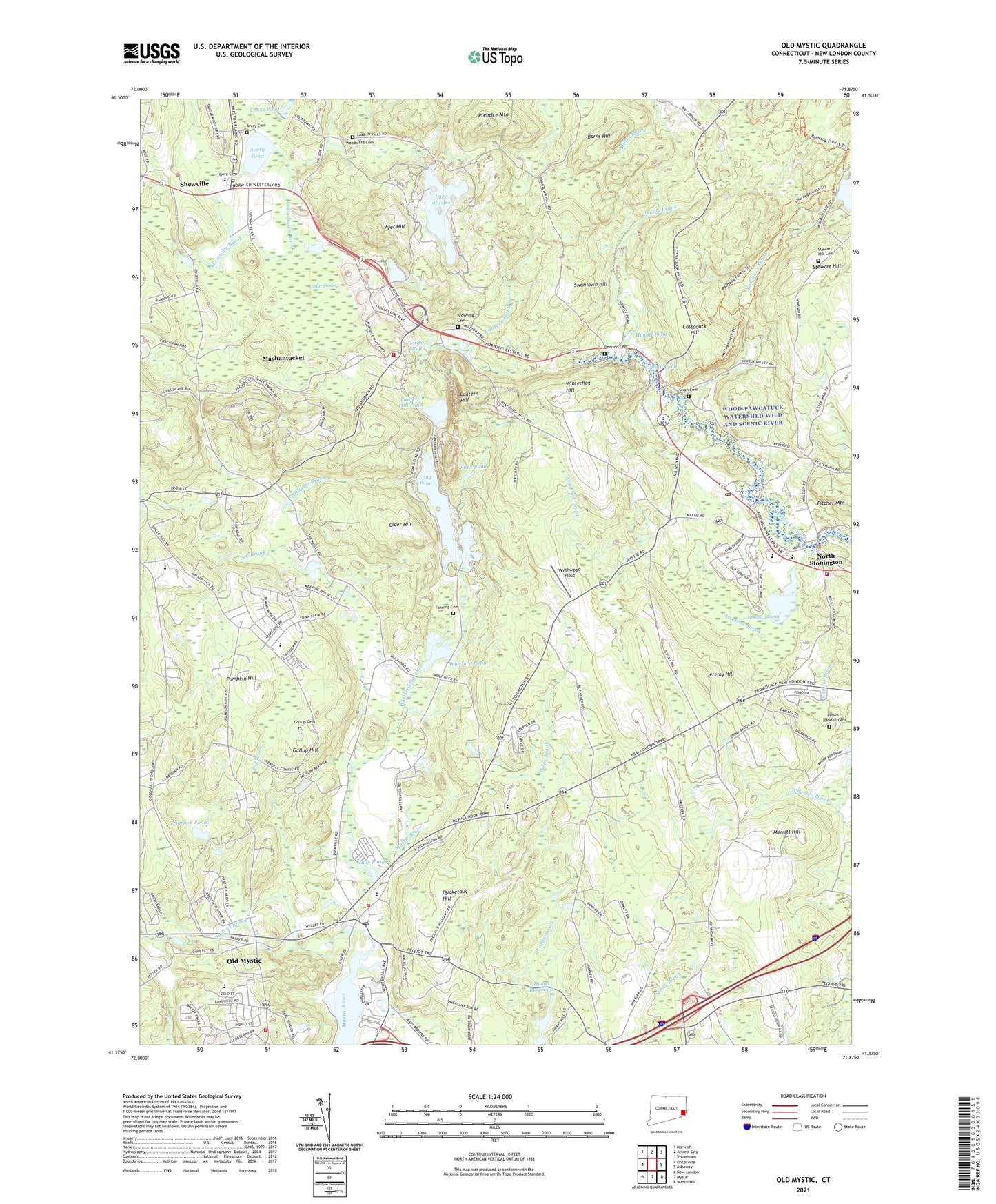
2024 topographic map quadrangle Old Mystic in the state of Connecticut. Scale: 1:24000. Based on the newly updated USGS 7.5' US Topo map series, this map is in the following counties: New London. The map contains contour data, water features, and other items you are used to seeing on USGS maps, but also has updated roads and other features. This is the next generation of topographic maps. Printed on high-quality waterproof paper with UV fade-resistant inks.
Quads adjacent to this one:
West: Uncasville
Northwest: Norwich
North: Jewett City
Northeast: Voluntown
East: Ashaway
Southeast: Watch Hill
South: Mystic
Southwest: New London
This map covers the same area as the classic USGS quad with code o41071d8.
Contains the following named places: Anchor Baptist Church, Assekonk Brook, Assekonk Swamp, Assekonk Swamp State Wildlife Management Area, Avery Cemetery, Avery Pond, Avon Park, Ayer Hill, Barns Hill, Board of Education Administration Office, Brown - Randall Cemetery, Browning Cemetery, Burnetts Corner, Butler Library, Cedar Swamp, Cider Hill, Cider Hill School, Clydes Cider Mill, Cooks Pond, Corey Sub Park, Cossaduck Hill, Creston Plains Elementary School, Deans Reservoir, Denison Cemetery, Fanning Cemetery, Fieldcrest Park, Foxwoods Casino, Freeman Hathaway Recreation Center, Freeman Hathaway School, Gallup Cemetery, Gallup Hill, Gallup Hill Baptist Church, Gallup Hill Elementary School, Gallup Hill School, Gallup Pond, Gore Cemetery, Haleys Brook, Hewitt Pond, Hewitt School, Highland Lake Park, Hyde Pond, Indian and Colonial Research Center, Indiantown Brook, Jeremy Hill, Lake of Isles, Lake Of Isles, Lake of Isles Brook, Lake of Isles Dam, Lantern Hill, Lantern Hill Brook, Lantern Hill Pond, Ledyard Assembly of God Church, Lee Brook, Long Pond, Long Pond Dam, Lords Pond, Lozier Sub Park, Main Brook, Mashantucket Census Designated Place, Mashantucket Pequot Fire Department, Mashantucket Pequot Reservation, Merritt Hill, Mystic Carousel and Fun Center, Mystic Education Center, Mystic Volunteer Fire Department Headquarters, Narragansett Trail, North Stonington, North Stonington Ambulance Association, North Stonington Church, North Stonington Elementary School, North Stonington Post Office, North Stonington Town Hall, North Stonington Town Recreation Area, North Stonington Village Historic District, North Stonington Volunteer Fire Company, Old Mystic, Old Mystic Baptist Church, Old Mystic Census Designated Place, Old Mystic Fire Department Station 1, Old Mystic Grammar School, Old Mystic Post Office, Old Mystic United Methodist Church, Paucatuck Eastern Pequot Reservation, Pequot Golf Course, Phelps Brook, Pitcher Mountain, Prentice Mountain, Preston Resident State Patrol Office, Pumpkin Hill, Quoketaug Hill, Red Brook, River Road Park, Saint Thomas Moore Church, Seaport Campground, Shady Oaks Park, Shewville, Shewville School, Silex Pond, Stewart Hill, Stewart Hill Cemetery, Stonington Vineyards, Swan Cemetery, Swantown Hill, Third Baptist Church, Town of North Stonington, Tribrook Pond, Tribrook Pond Dam, West Branch Red Brook, Wheeler Brook, Wheeler High School, Wheeler Library, Wheeler Middle School, Whitehall Landing, Whitehall Mansion, Whitford Brook, Whitford Pond Dam, Williams Brook, Wintechog Hill, Woodward Cemetery, Wychwood Field, Yawbucs Brook, ZIP Codes: 06339, 06378