MyTopo
Anderson South South Carolina US Topo Map
Couldn't load pickup availability
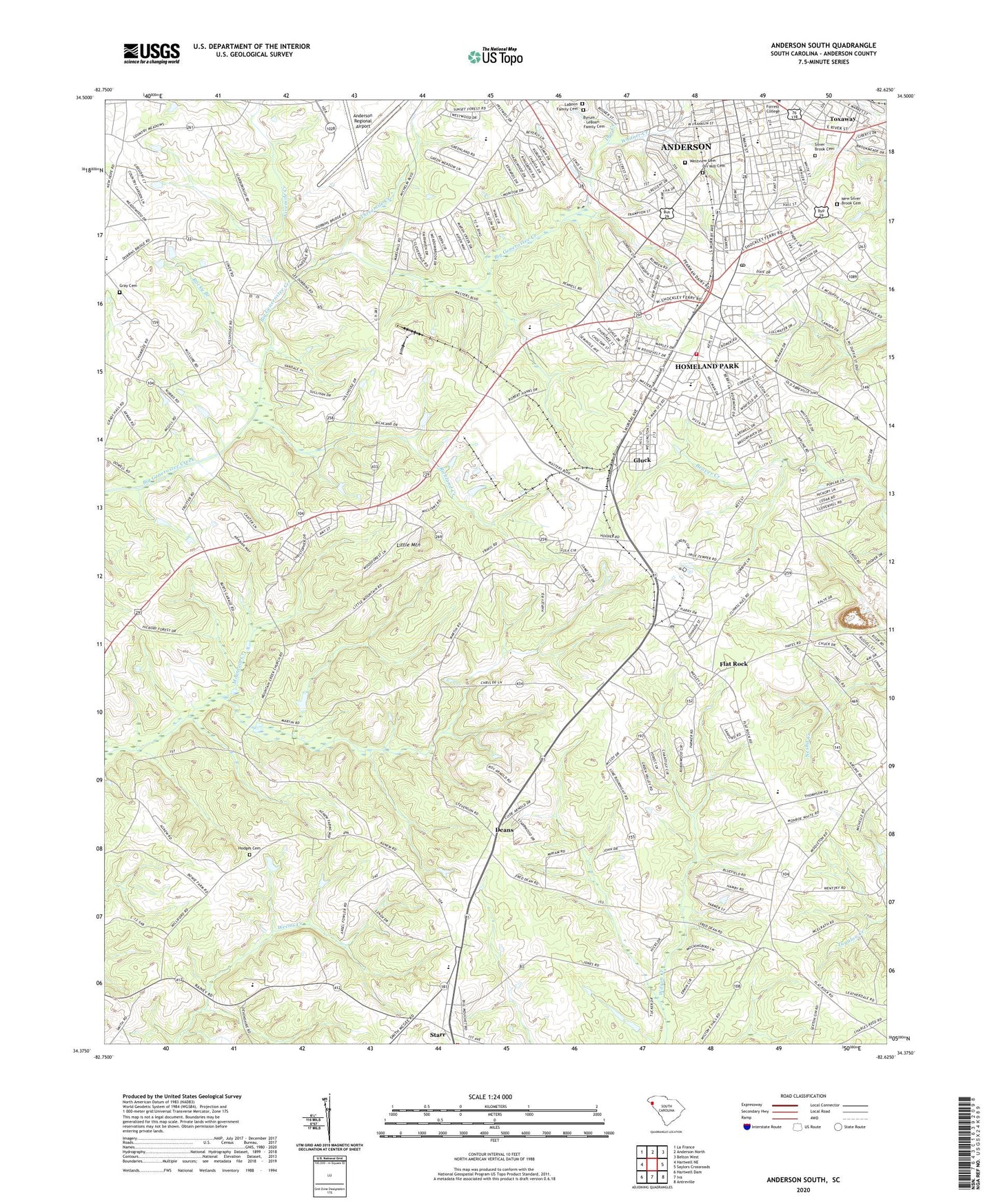
2020 topographic map quadrangle Anderson South in the state of South Carolina. Scale: 1:24000. Based on the newly updated USGS 7.5' US Topo map series, this map is in the following counties: Anderson. The map contains contour data, water features, and other items you are used to seeing on USGS maps, but also has updated roads and other features. This is the next generation of topographic maps. Printed on high-quality waterproof paper with UV fade-resistant inks.
Quads adjacent to this one:
West: Hartwell NE
Northwest: La France
North: Anderson North
Northeast: Belton West
East: Saylors Crossroads
Southeast: Antreville
South: Iva
Southwest: Hartwell Dam
Contains the following named places: American Legion Memorial Athletic Field, Anderson Army Air Field, Anderson Country Club, Anderson County Fire Department Homeland Park Station 3, Anderson Division, Anderson Mennonite Church, Anderson Regional Airport, Bethel African Methodist Episcopal Church, Beverly Hills, Boys High School, Byrum - LeBoon Family Cemetery, Caldwell Village, Calhoun Hills, Carolina Springs, Chambert Forest, Chamblee Pond Dam D-3111, Chamblees Mill, Cherokee Farms, Christian Fellowship Outreach, Christopher Heights, Clover Hill, Cloverdale, Deans, Deans Presbyterian Church, Dobbins Pond Dam D-3116, Durham Shopping Center, Dye Creek, Eastpoint Shopping Center, Fant Street Graded School, Fernwood, First Assembly of God Church, Fivemile Creek, Flat Rock, Flat Rock Baptist Church, Flat Rock Church, Flat Rock School, Freewill Church, Gladstone Acres, Glenn Pond Dam Number Two D-3108, Glenn Pond Number One D-3109 Dam, Gluck, Gospel Fellowship Mission, Grace Church, Grace Episcopal Church, Gray Cemetery, Green Acres, Greenbriar, Hardy Berry Farm, Haynies Mill, Hill Pond Dam D-3110, Hodges Cemetery, Homeland Park, Homeland Park - John Wesley United Methodist Church, Homeland Park Baptist Church, Homeland Park Census Designated Place, Homeland Park Church of God, Homeland Park Elementary School, Indian Trail, Jefferson Chapel, Kennedy Street School, LaBoon Family Cemetery, Little Mountain, Lyonswood, Marshall Memorial Church, McAlister Greenhouses, Meadow Fields, Meadow Park, Mount Carmel Church, Mount Herman Baptist Church, Mount Hermon School, Mount Moriah Baptist Church, Mount Moriah School, Mount Olive Baptist Church, Mountain Creek, Mountain Creek Baptist Church, Mountain Creek Post Office, Mountain Creek School, New Deal School, New Harmony Church, New Silver Brook Cemetery, Old Bethesda Methodist Church, Orr Mill Cemetery, Orr Mill Park, Orrville Baptist Church, Orrville United Methodist Church, Pentecostal Holiness Church, Perry School, Pine Forest, Richland Creek, River Street Baptist Church, River Street Plaza Shopping Center, Riverside Baptist Church, Rock Hill Baptist Church, Rocky Branch, Royal Baptist Church, Rucker Court, Saint Marys Church, Saint Paul First Baptist Church, Salem Church, Silver Brook Cemetery, Smith Chapel Methodist Church, Soul Deliverance Center, South Anderson Baptist Chapel, South Fant Street School, Southgate Shopping Center, Southside Baptist Church, Southside School, Southwood Middle School, Southwood Park, Starr, Starr Baptist Church, Starr Elementary School, Starr Methodist Church, Strickland Pond Dam D-3117, Taylors School, Threemile Creek, Town of Starr, Toxaway, United House of Prayer for All People, Vandale Place, Varennes Elementary School, Varennes Heights, Varennes Heights Baptist Church, Victory Baptist Church, Watson Village Shopping Center, Watsons Mill, Wellington Pentecostal Holiness Church, Wesleyan Church, West Market Street School, Westside High School, Westview Cemetery, Westview Heights, White Street Park, Whitner Creek, WRIX-AM (Homeland Park), Zion Pentecostal Holiness Church, ZIP Code: 29684