MyTopo
Bluffton South Carolina US Topo Map
Couldn't load pickup availability
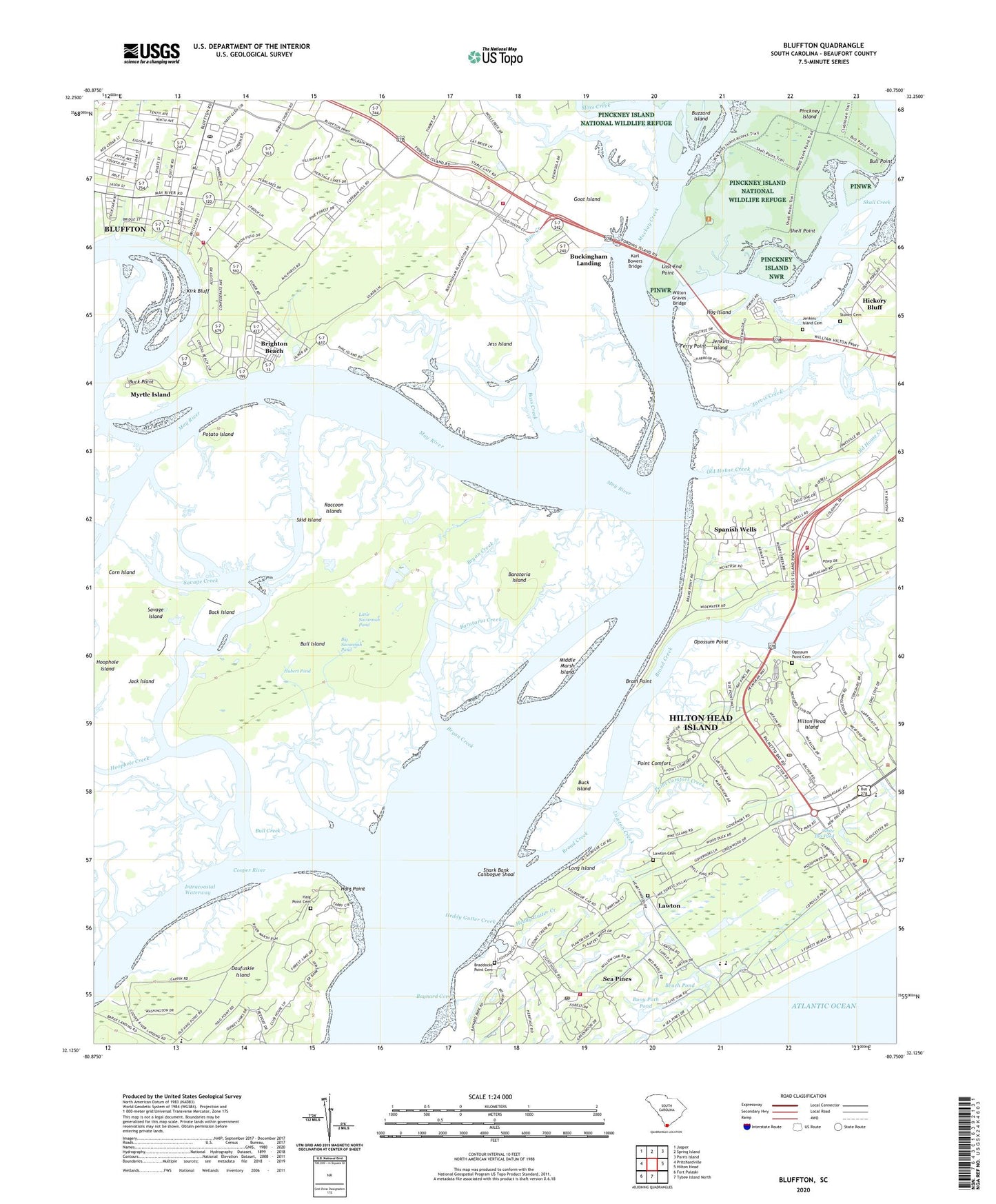
2020 topographic map quadrangle Bluffton in the state of South Carolina. Scale: 1:24000. Based on the newly updated USGS 7.5' US Topo map series, this map is in the following counties: Beaufort. The map contains contour data, water features, and other items you are used to seeing on USGS maps, but also has updated roads and other features. This is the next generation of topographic maps. Printed on high-quality waterproof paper with UV fade-resistant inks.
Quads adjacent to this one:
West: Pritchardville
Northwest: Jasper
North: Spring Island
Northeast: Parris Island
East: Hilton Head
Contains the following named places: Back Island, Barataria Creek, Barataria Island, Bass Creek, Bay Pines, Baynard Cove, Beach Pond, Beaufort County Courthouse Annex, Beaufort County Library Bluffton Branch, Big Savannah Pond, Bluffton, Bluffton Post Office, Bluffton Township Fire District Station 30, Bluffton Township Fire District Station 33, Braddocks Point Cemetery, Bram Point, Brighton Beach, Broad Creek, Broad Creek Community, Broad Creek Marina, Bryan Creek, Bryan Landing, Buck Island, Buck Point, Buckingham Landing, Buckingham School, Bull Creek, Bull Island, Bull Point, Buoy Path Pond, Buzzard Island, Calibogue Cay, Calibogue Shoal, Church of the Cross, Coligny Circle, Coligny Plaza Shopping Center, Cooper River Landing, Cooper River School, Cope Church, Corn Island, Daufuskie Island Elementary School, Executive Golf Club, Fairway Oaks, Ferry Point, Goat Island, Greenwood Forest, Haig Point, Haig Point Cemetery, Harbour Town, Harbour Town Shopping Center, Harbour Town Yacht Basin, Harbourtown Post Office, Heddy Gutter Creek, Heritage Academy, Heritage Woods, Hickory Bluff, Hilton Head Harbor, Hilton Head Island, Hilton Head Island Fire Rescue Station 1, Hilton Head Island Fire Rescue Station 2, Hilton Head Island Fire Rescue Station 7, Hilton Head Island Post Office, Hilton Head Preparatory School, Hog Island, Honey Horn School, Hoophole Creek, Hoophole Island, Horse Landing, Hubert Pond, Jack Island, Jarvis Creek, Jenkins Island, Jenkins Island Cemetery, Jess Island, Karl Bowers Bridge, Kingdom Hall of Jehovahs Witnesses, Kirk Bluff, Last End Point, Lawton, Lawton Cemetery, Lawton Creek, Little Savannah Pond, Long Island, Mackay Creek, May River, May River Academy, Michael C Riley Elementary School, Middle Marsh Island, Moss Creek, Myrtle Island, Old House Creek, Opossum Point, Opossum Point Cemetery, Opossum Point Landing, Orleans Plaza Shopping Center, Palmetto Bay Marina, Palmetto Bay Shopping Center, Pinckney Island, Point Comfort, Point Comfort Creek, Point Comfort Woods, Pope Avenue Mall Shopping Center, Potato Island, Raccoon Islands, Savage Creek, Savage Island, Sea Pines, Sea Pines Circle, Sea Pines Club, Sea Pines Forest Preserve, Sea Pines Montessori School, Sea Pines Plantation, Shark Bank, Shell Point, Six Oaks Cemetery, Skid Island, Skull Creek, South Beach Marina, South Island Public Sanitation Department, Spanish Wells, Spanish Wells Golf Club, Stoney Cemetery, The Village at Wexford Shopping Center, Wexford Golf Club, Wexford Plantation, WHHR-FM (Hilton Head Island), White Ibis Pond, WIJY-FM (Hilton Head Island), Wilton Graves Bridge, Windmill Harbor, WLOW-FM (Bluffton), ZIP Code: 29928