MyTopo
Mullins South Carolina US Topo Map
Couldn't load pickup availability
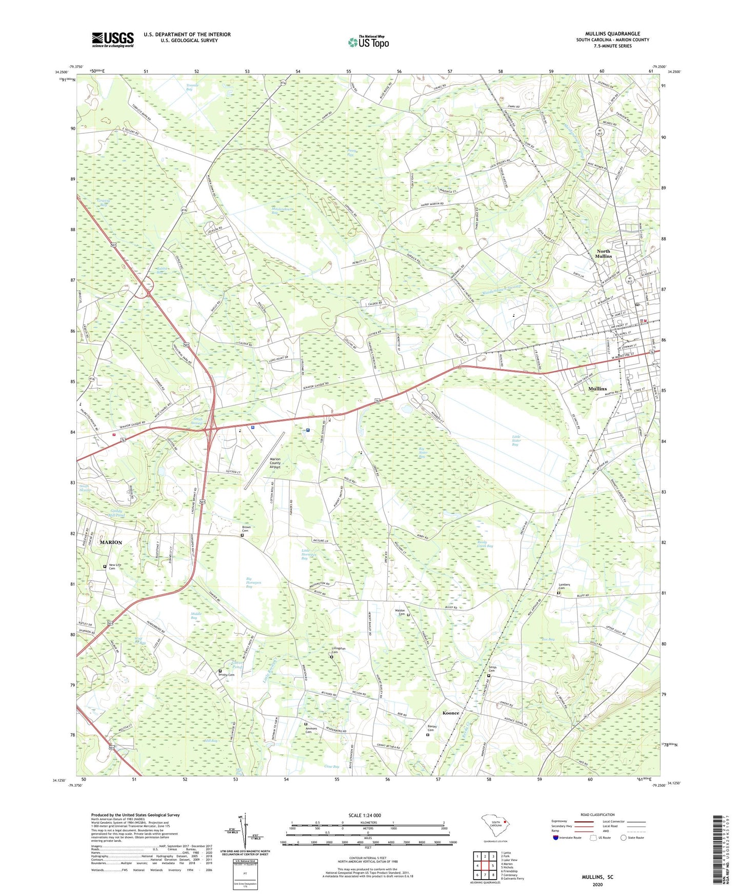
2024 topographic map quadrangle Mullins in the state of South Carolina. Scale: 1:24000. Based on the newly updated USGS 7.5' US Topo map series, this map is in the following counties: Marion. The map contains contour data, water features, and other items you are used to seeing on USGS maps, but also has updated roads and other features. This is the next generation of topographic maps. Printed on high-quality waterproof paper with UV fade-resistant inks.
Quads adjacent to this one:
West: Marion
Northwest: Latta
North: Fork
Northeast: Lake View
East: Nichols
Southeast: Galivants Ferry
South: Centenary
Southwest: Friendship
This map covers the same area as the classic USGS quad with code o34079b3.
Contains the following named places: Ammons Cemetery, Baxley Cemetery, Beulah Methodist Episcopal Church, Big Horsepen Bay, Big Sister Bay, Brown Cemetery, Carolinas Hospital System - Marion, Christ Episcopal Church, Christian Faith Baptist Church, Church of Christ, City of Mullins, Country Club Estates, Dusty Hill Golf Club, East Marion Pentecostal Holiness Church, Ebenezer African Methodist Episcopal Church, Effingham Church, Ellen Chapel Holiness Church, First Faith Assembly Church, Fox Bay, Gaddy Mill Pond, Gaddys Millpond D-0512 Dam, Gapway School, Gator Pond, Grassy Bay, Highway Church of Christ, Holy Temple Church of God In Christ, House of God In Mullins, Kingdom Hall of Jehovahs Witnesses, Koonce, Lambert Cemetery, Little Bethel Baptist Church, Little Horsepen Bay, Little Sister Bay, Livingston Cemetery, Macedonia United Methodist Church, Maidendown Bay, Marion County Airport, Marion County Emergency Management Office, Marion County Law Enforcement Center, Marion County Sheriff's Office, Marion County Technical Education Center, Marion Fire Department Station 15, Marion Intermediate School, Marion Police Department Substation, Marion Towne Center, Martins Hospital, Middle Bay, Mill Bay, Mount Carmel Baptist Church, Mount Olive Baptist Church, Mullins, Mullins - Marion Original Free Will Baptist Church, Mullins Branch Marion County Library, Mullins City Hall, Mullins Early Childhood Center, Mullins Fire Department, Mullins First Baptist Church, Mullins First Pentecostal Holiness Church, Mullins Freewill Baptist Pentecostal Faith, Mullins Grade School, Mullins High School, Mullins Municipal Court, Mullins Nursing Center, Mullins Police Department, Mullins Post Office, Mullins Presbyterian Church, New Life Cemetery, New Life Church, North Mullins, North Mullins Baptist Church, North Mullins Primary School, Palmetto Elementary School, Palmetto High School, Palmetto Middle School, Peedee Association Church, Pendeboro, Penderborough School, Piney Bay, Pleasant Grove Church, Pleasant Grove Missionary Baptist Church, Pleasant Hill Church, Pleasant Hill School, Progressive Church of Our Lord Jesus Christ, Rabbit Bay, Reedy Creek Bay, Sandy Grove Church, Smith Cemetery, Smith Swamp, Smith Swamp School, Smithy Cemetery, South Carolina Tobacco Museum, The First Pentecostal Holiness Church, Todd School, Tranquil Church, Waldon Cemetery, WCIG-FM (Mullins), Wise Chapel, WJAY-AM (Mullins), WKXS-AM (Marion), Wolf Pit Bay, ZIP Code: 29574