MyTopo
Myrtle Beach South Carolina US Topo Map
Couldn't load pickup availability
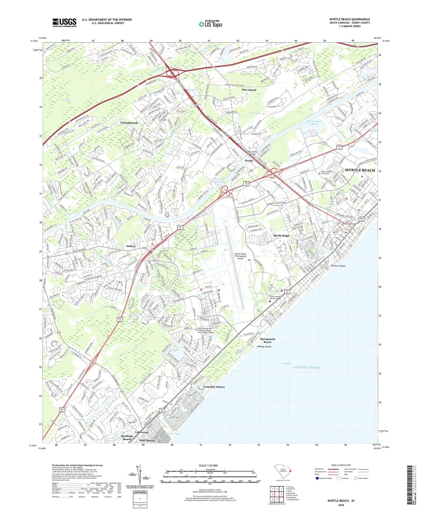
2024 topographic map quadrangle Myrtle Beach in the state of South Carolina. Scale: 1:24000. Based on the newly updated USGS 7.5' US Topo map series, this map is in the following counties: Horry. The map contains contour data, water features, and other items you are used to seeing on USGS maps, but also has updated roads and other features. This is the next generation of topographic maps. Printed on high-quality waterproof paper with UV fade-resistant inks.
Quads adjacent to this one:
West: Bucksville
Northwest: Conway
North: Nixonville
Northeast: Hand
East: Ocean Forest
South: Surfside Beach
Southwest: Brookgreen
This map covers the same area as the classic USGS quad with code o33078f8.
Contains the following named places: Arrowhead Country Club, Base Recreation Center, Belle Terre Golf Links, Bible Baptist Church, Bible Fellowship Church, Big Swamp School, Broadway at the Beach, Brookgate, Calvary Bible Church, Calvary Christian School, Canal Street Recreation Center, Carver School, Chapin Memorial Library, Chapin Memorial Park, Church of the Nazarene, Cimerron Plantation South, City of Myrtle Beach, City of Myrtle Beach Fire Department Station 3, City of Myrtle Beach Fire Department Station 4, Cross Swamp, Crystal Lake, Cypress Creek, Deer Track Villas, Deerfield Plantation, Dick Pond, Dogwood, First Baptist Church, First Batist Vietnamese Church of Myrtle Beach, First Presbyterian Church, First United Methodist Church, Folly Swamp, Forestbrook, Forestbrook Baptist Church, Forestbrook Census Designated Place, Forestbrook Elementary School, Forestbrook Middle School, Friendship Baptist Church, Grand Strand Baptist Church, Grand Strand Christian Academy, Grand Strand Plaza Shopping Center, Gross Swamp, Heathland at the Legends Golf Course, Horry - Georgetown Technical College, Horry County Fire Department Forestbrook Station 4, Horry County Fire Department South Myrtle Beach, Horry County Fire Department Station 30, Hunter Fields, Hurl Rocks, Javika Airport, Kiddie College, Kingway Pentecostal Holiness Church, Konig, Lakewood, Lakewood Campground, Lakewood Elementary School, Lewis Lake, Long Bay Estates, Midway, Midway Church, Midway Park, Midway Swash, Mount Carmel Church, Myrtle Beach, Myrtle Beach Air Force Base, Myrtle Beach Airport Police Department, Myrtle Beach Army Air Field, Myrtle Beach Assembly of God Church, Myrtle Beach Bible Chapel, Myrtle Beach City Hall, Myrtle Beach Division, Myrtle Beach Estates, Myrtle Beach Fire Department Station 1, Myrtle Beach Grammar School, Myrtle Beach International Airport, Myrtle Beach Jetport Fire Department, Myrtle Beach Junior High School, Myrtle Beach Lagoon, Myrtle Beach Police Department, Myrtle Beach Police Department - Administrative Division, Myrtle Beach Post Office, Myrtle Beach State Park, Myrtle Heights, Myrtle Ridge, Myrtlewood Golf Course, Negro Field Swamp, Ocean Bay, Ocean Lakes, Ocean Woods Memorial Park, Outlet Park at Waccamaw Shopping Center, Owens, Pebble Beach, Pine Island, Pine Island Bridge, Pine Island School, Pinelands, Pirateland Campground, Plantation Point, Plantation Square Shopping Center, Platt Spring, Pleasant Hill Church, Prestwick, Ramsey Acres, River Oaks Golf Plantation, Rosewood, Saint Marys Church, Saint Stephen Church, Scott Acres, Seaboard Industrial Park, Seaview Place, Shady Grove Campground, Sixth Avenue South Shopping Center, Socastee, Socastee Baptist Church, Socastee High School, Socastee Swamp, South Carolina Noname 26035 D-3637 Dam, Springmaid Beach, Stalvey, Surfside Beach Rescue Squad, Tarpon Bay, The Franklin G Burroughs - Simeon B Chapin Art Museum, The Landing at Plantation Point, Villa Woods, Watergate, Westwood Estates, Whispering Pines Golf Course, Witch Golf Links, Withers Heights, Withers Swash, WJYR-FM (Myrtle Beach), WKEL-AM (Myrtle Beach), WKZQ-AM (Myrtle Beach), Woodland Park, Woodland Park School, Yaupon Circle, ZIP Codes: 29575, 29577