MyTopo
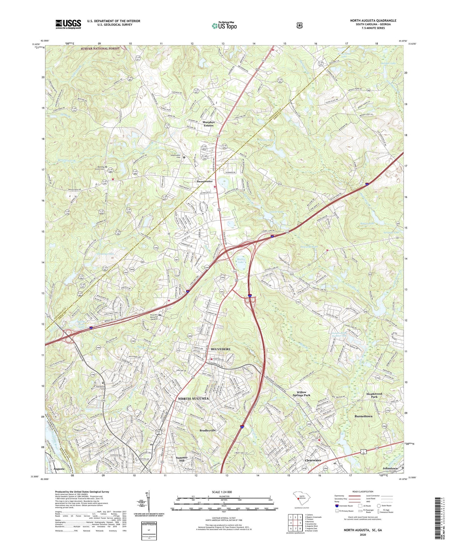
North Augusta South Carolina US Topo Map
Couldn't load pickup availability
Also explore the North Augusta Forest Service Topo of this same quad for updated USFS data
2024 topographic map quadrangle North Augusta in the states of South Carolina, Georgia. Scale: 1:24000. Based on the newly updated USGS 7.5' US Topo map series, this map is in the following counties: Aiken, Edgefield, Richmond. The map contains contour data, water features, and other items you are used to seeing on USGS maps, but also has updated roads and other features. This is the next generation of topographic maps. Printed on high-quality waterproof paper with UV fade-resistant inks.
Quads adjacent to this one:
West: Martinez
Northwest: Colliers
North: Ropers Crossroads
Northeast: Trenton
East: Graniteville
Southeast: Hollow Creek
Southwest: Augusta West
This map covers the same area as the classic USGS quad with code o33081e8.
Contains the following named places: Antique Lake, Arrowhead Lake, Arrowhead Lakes, Ascaga Heights, Ascauga Lake, Audubon Homes, Augusta Canal, Augusta View Heights, Bahama Heights, Bakers Lake, Barclay Estates, Bath Fire Department Station 2 Woodridge Station, Belclear, Bel-Clear Heights Church, Bel-Ridge Baptist Church, Belvedere, Belvedere Census Designated Place, Belvedere Elementary School, Belvedere Fire Department, Belvedere Fire Department Station 2, Belvedere Shopping Center, Belvedere United Methodist Church, Big Cone Ridge, Bonnie Glen, Bradleyville, Brierfield, Brogden, Brookgreen, Capital City Ambulance, Carolina Terrace, City of North Augusta, Clearwater Census Designated Place, Clearwater Lake, Clearwater Lake Dam, Country Place, County Line Fire Department, Coventry, Crestdale, Crestland, Edgefield Heights, Edgewood Square Shopping Center, Fairview Gardens, Fairview Presbyterian Church, First Baptist Church of Belvedere, Floyd School, Franklin Branch, Garner Pond Number One, Georgia Avenue-Butler Avenue Historic District, Graniteville - Vaucluse - Warrenville Fire Department Station 3, Greenfield, Gregorys Lake, Hammond Cemetery, Hammond Grove Church, Hammond Hill School, Hammond Hills, Heatherwood, Heathwood Park, Holy Trinity Lutheran Church, Horse Creek, Howards Pond, Huntington Estates, Lake Forest Estates, Lakewood, Laurel Lake, Laurel Lake Dam D-2023, Laurel Lakes, Levingsworths Mill, Lynnhurst, Martintowne, Mathis Lake, Mealing Grove Baptist Church, Meeting Grove Cemetery, Merriwether Volunteer Fire Department, Mims Branch, Mims Grove Church, Mount Figuration Church, Mount Figuration School, Murphys Estates, Murphys Estates Census Designated Place, North Augusta, North Augusta Academy, North Augusta Church of Christ, North Augusta Division, North Augusta Fire Department Station 2, North Augusta Golf Club, North Augusta High School, North Augusta Post Office, Pine and Oak Woods, Pine Grove Baptist Church, Pine Grove School, Pine Knox Junior High School, Pine Valley, Pinecrest, Pinehurst, Pineview Estates, Pineview Memorial Gardens, Pinewood Plantation, Pole Branch, Pretty Run Creek, Providence Church, Randall Pond Dam D-1699, Ridge Hill Church, Ridgecrest, Ridgeview Baptist Church, Rose Hill, Saint Bartholomews Church, Sandlewood, Shannon, Smithfield, South Carolina Noname 02007 D-1993 Dam, South Carolina Noname 02023 D-2003 Dam, South Carolina Noname 02032 D-2005 Dam, South Carolina Noname 02061 D-2014 Dam, South Carolina Noname 02071 D-2165 Dam, South Carolina Noname 02088 D-2042 Dam, South Carolina Noname 02134 D-2021 Dam, South Carolina Noname 19030 D-0874 Dam, South Carolina Noname 19032 D-0873 Dam, South Carolina Noname 19040 D-0901 Dam, South Carolina Noname Dam 02038, Sudlow Lake, Summer Hill, Summerfield Elementary School, Summerfield Elementary School Annex, Sweetwater, Sweetwater Baptist Church, Sweetwater Cemetery, Swints Lake, The Colony, Triune School, Walker School, WBBQ-FM (Augusta), Wellington, WFXA-AM (Augusta), WFXA-FM (Augusta), Willow Springs Park, Willow Wicks Lake, Windtree, WLPE-FM (Augusta), Woodlawn, Woodridge, Woodridge Baptist Church, Young Macedonia Church, ZIP Codes: 29841, 29860