MyTopo
Belton East South Carolina US Topo Map
Couldn't load pickup availability
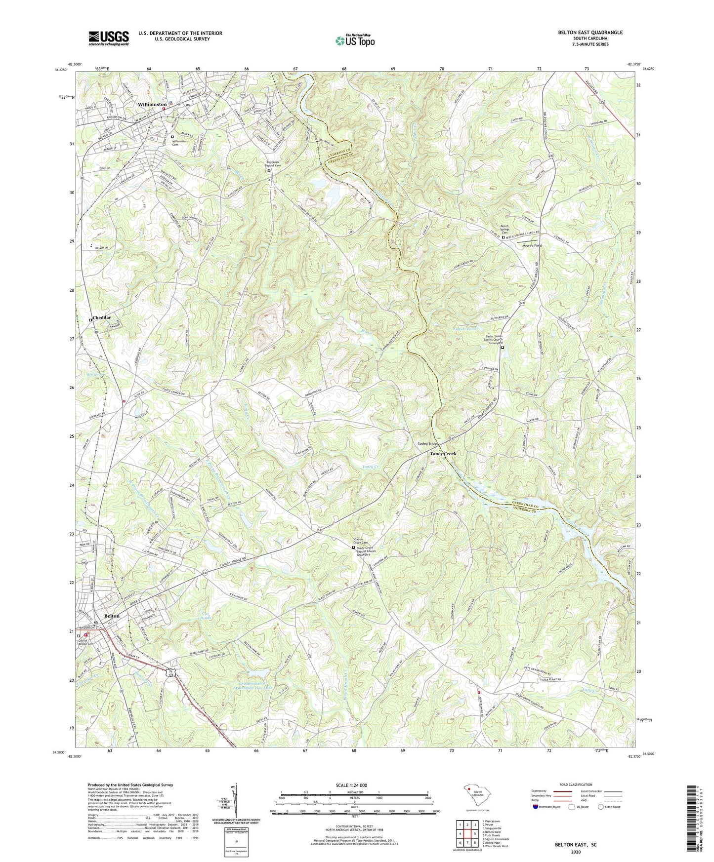
2024 topographic map quadrangle Belton East in the state of South Carolina. Scale: 1:24000. Based on the newly updated USGS 7.5' US Topo map series, this map is in the following counties: Anderson, Greenville. The map contains contour data, water features, and other items you are used to seeing on USGS maps, but also has updated roads and other features. This is the next generation of topographic maps. Printed on high-quality waterproof paper with UV fade-resistant inks.
Quads adjacent to this one:
West: Belton West
Northwest: Piercetown
North: Pelzer
Northeast: Simpsonville
East: Fork Shoals
Southeast: Ware Shoals West
South: Honea Path
Southwest: Saylors Crossroads
This map covers the same area as the classic USGS quad with code o34082e4.
Contains the following named places: Anderson County Fire Department Cheddar Station 12, Anderson County Fire Department Friendship Station 15, AnMed Wellspring Treatment Center, Assembly Acres Camp Lake, Assembly Acres Camp Lake Dam D-2881, August Pond, August Pond Dam D-2861, Beech Springs Cemetery, Beech Springs Church, Belton, Belton Branch Anderson County Library, Belton City Fire Department, Belton Elementary School, Belton Emergency Medical Services, Belton High School, Belton Post Office, Belton Presbyterian Church, Big Creek, Big Creek Baptist Cemetery, Big Creek Baptist Church, Broadmouth Creek Watershed Eight Lake, Broadmouth Creek Watershed Nine Lake, Broadmouth Creek Watershed Two Lake, Brown Salem Baptist Church, Calhoun School, Callaham Orchards, Cedar Grove Baptist Church, Cedar Grove Baptist Church Graveyard, Cedar Grove Elementary School, Cedar Shoals Baptist Church Graveyard, Cedar Shoals Church, Center Star School, Central Grammar School, Cheddar, City of Belton, City of Belton Cemetery, Clarks Ferry, Cooley Bridge, Cox Ponds, Crymes Mill, Dry Oak Church, East Prong Broadmouth Creek, First Baptist Church, Friendship School, G Stevens Pond Dam D-3147, Grove Creek, Holidays Bridge Dam, Hollands Ford, Holly Springs Baptist Church Graveyard, Holly Springs Church, Latimer Memorial Methodist Church, Medshore Ambulance Service, Moore's Field, New Hope Church, New Hope School, Oak Grove School, Oak Hill Church, Oak Hill School, Pelzer Mills Dam, Pelzer Mills Dam D-2848, Pierces Ford, Rice Mills Pond Dam D-3145, Shadow Grove Cemetery, Shady Grove Baptist Church, Shady Grove Baptist Church Graveyard, Silver Hill School, South Carolina Noname 04010 D-3146 Dam, South Carolina Noname 04012 D-3143 Dam, South Carolina Noname 04013 D-3142 Dam, South Carolina Noname 04028 D-3144 Dam, Toney Creek, Tony Creek Post Office, Town of Williamston, West Dunklin School, West Prong Broadmouth Creek, WHPB-AM (Belton), Williamston, Williamston Cemetery, Williamston Female College, Williamston Fire Department, Williamston Police Department, Wilsons Mill, ZIP Code: 29627