MyTopo
Custer South Dakota US Topo Map
Couldn't load pickup availability
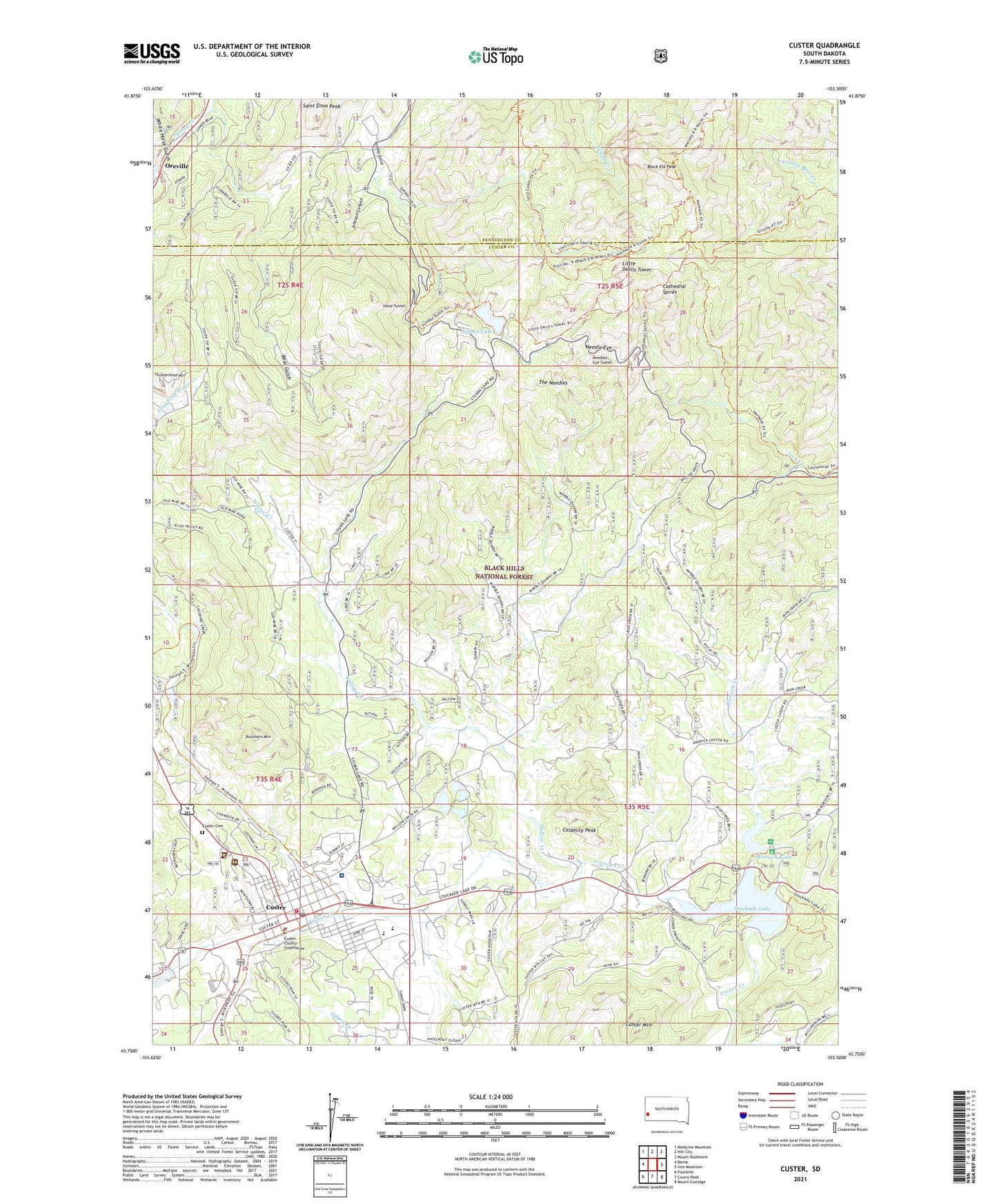
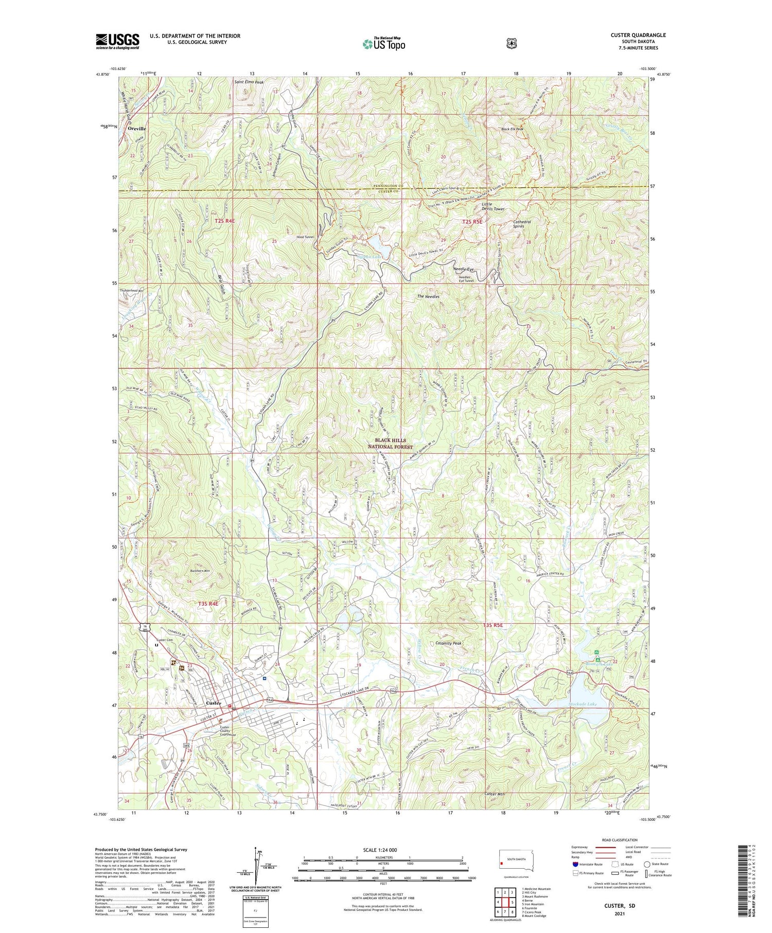
2021 topographic map quadrangle Custer in the state of South Dakota. Scale: 1:24000. Based on the newly updated USGS 7.5' US Topo map series, this map is in the following counties: Custer, Pennington. The map contains contour data, water features, and other items you are used to seeing on USGS maps, but also has updated roads and other features. This is the next generation of topographic maps. Printed on high-quality waterproof paper with UV fade-resistant inks.
Quads adjacent to this one:
West: Berne
Northwest: Medicine Mountain
North: Hill City
Northeast: Mount Rushmore
East: Iron Mountain
Southeast: Mount Coolidge
South: Cicero Peak
Southwest: Fourmile
Contains the following named places: 1881 Courthouse Museum, A M Lode Mine, Aladdin Mine, Arcade Numbers 1 and 2 Lodes Mine, Bear Gulch, Bet Lode Mine, Big Horn Lode Mine, Bismark Creek, Bismark Lake, Bismark Lake Campground, Bismark Lake Dam, Black Elk Peak, Bob Marshall Organization Camp, Buckhorn Mountain, Calamity Peak, Cathedral Spires, Cathedral Spires Trail, City of Custer, Clara Belle Camp, Clara Belle Mine, Climax Mica Mine, Collins Ranch, Come Along Lode Mine, Crazy Horse Memorial, Custer, Custer Ambulance Service, Custer Cemetery, Custer City Hall, Custer County Courthouse, Custer County Library, Custer County Sheriff's Office, Custer Elementary School, Custer High School, Custer Mica Lodes Numbers 1 and 2 Mine, Custer Middle School, Custer Mountain, Custer Mountain Lode Mine, Custer Post Office, Custer State Park - Norbeck Wildlife Preserve, Custer Volunteer Fire Department, Dalmon Mica Mine, E M Lode Mine, Earl Lode Mine, First Find Mine, Fort Defiance, Gap Lode Mine, Gira and Ainsleys Dike Mine, Glenerin School, Grand Junction, Homestead Number 2 Prospect Mine, Homestead Number 3 Prospect Mine, Hood Tunnel, IXL Fraction Mine, IXL Lode Mine, IXL Lode Number 3 Mine, IXL Number 4 Lode Mine, Johnson Canyon, Knowles Lode Claim Mine, Lake Mine, Little Devils Tower, Lost Bonanza Mine, Lost Cabin I, Lost Cabin Trail, Mica Queen Number 1 Prospect Mine, Mitchell Number 2 Lode Mine, Mohawk Mica Prospect Mine, Monument Health Custer Hospital, Needle Eye, Needles Eye Tunnel, New Deal Lode Mine, Noble Mica Mine, November Mine, OK Lode Mine, OK Number 2 Lode Mine, OK Number 4 Lode Mine, Old Mike Mine, Oreville, Oreville Campground, Oreville Spar Mine, Paha Sapa Trail, Phelps Lode Mine, Pick Lode Mine, Poppy Lode Mine, Rossville, Saint Elmo Mine, Saint Elmo Peak, Shamrock Number 1 Lode Mine, Sky Lode Mine, Smith Ranch, South Dakota State Highway Patrol - Southern Hills Office, Stockade Lake, Stockade Lake Dam, Sunday Gulch Trail, Sunshine Mica Prospect Mine, Surprise Mica Mine, Sylvan Lake, Sylvan Lake Dam, Sylvan Lake Harney Trail, Sylvan Lake Post Office, Sylvan Lake Resort, Sylvanite Lode Mine, Tenderfoot Creek, Terry and Terry Number 1 Claims Mine, The Needles, Thunderhead Mountain, Tiblis Ranch, Tillisons Mine, Tin King Mine, Tin Queen Mine, Tungsten Lode Mine, Upper Pine Creek Natural Area, Victory Mine, Victory Number 1 Prospect Mine, Walsh Mica Prospect Mine, White Horse Creek, White Horse Gulch, Wild Rose Mine, Willow Creek