MyTopo
Camelot Tennessee US Topo Map
Couldn't load pickup availability
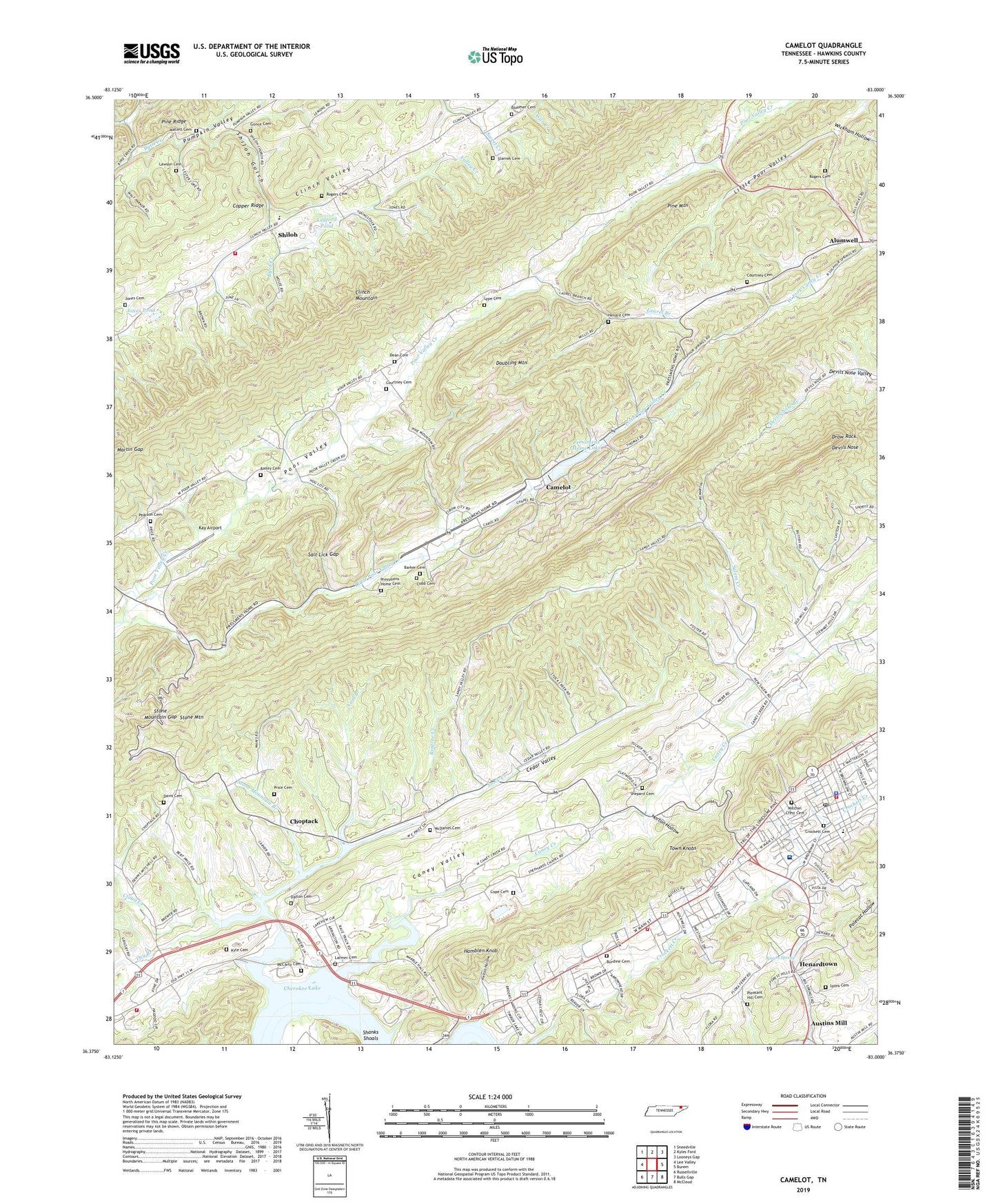
2019 topographic map quadrangle Camelot in the state of Tennessee. Scale: 1:24000. Based on the newly updated USGS 7.5' US Topo map series, this map is in the following counties: Hawkins. The map contains contour data, water features, and other items you are used to seeing on USGS maps, but also has updated roads and other features. This is the next generation of topographic maps. Printed on high-quality waterproof paper with UV fade-resistant inks.
Quads adjacent to this one:
West: Lee Valley
Northwest: Sneedville
North: Kyles Ford
Northeast: Looneys Gap
East: Burem
Southeast: McCloud
South: Bulls Gap
Southwest: Russellville
Contains the following named places: Altonville, Alumwell, Bailey Cemetery, Barker Cemetery, Bloomer Cemetery, Bridgeport Church, Burdine Cemetery, Byrd Creek, Camelot, Caney Creek, Caney Valley, Cedar Valley, Cherokee High School, Choptack, Choptack Baptist Church, Choptack School, Clinch School, Clinch Valley Volunteer Fire Department Station 2, Cloud Creek, Cobb Cemetery, Cobb School, Cobbs Chapel, Commissioner District 6, Cool Branch, Cope Cemetery, Courtney Cemetery, Crockett Cemetery, Dalton Cemetery, Davis Cemetery, Dean Cemetery, Devils Nose, Doubling Mountain, Draw Rock, Dry Branch, Eidson Division, Fairview School, Gonce Cemetery, Hamblen Knob, Hawkins County Courthouse, Hawkins County Jail, Hawkins County Memorial Hospital, Helton Hollow, Henard Cemetery, Henards Chapel Baptist Church, Henardtown, Horton Hollow, Jones Cemetery, Jones Pond, Kay Airport, Klepper Chapel, Klepper School, Kyle Cemetery, Kyle Quarry, Lakeview School, Lakeview Volunteer Fire Department Station 1, Larmer Cemetery, Laurel Branch, Laurel View Church, Lawson Cemetery, Ledford Pond, Little Poor Valley, Little Poor Valley Creek, Lyons Cemetery, Lype Cemetery, Macedonia Church, Maddox Ford, Mallett Cemetery, Maple Hill Baptist Church, Maple Hill School, Marble Hall, Marble Hall School, Martin Gap, McCarty Cemetery, McDaniel Cemetery, Memorial Chapel, Mitchel Crest Cemetery, New Salem Church, New Salem School, Oak Hill School, Pearson Cemetery, Pilgrims Rest Church, Pleasant Hill Cemetery, Pleasant Hill Church, Pressmens Home Cemetery, Pressmens Home Dam, Pressmens Home Lake, Price Cemetery, Renfroe Creek, Rippys Island, Rogers Cemetery, Rogersville, Rogersville City Hall, Rogersville Division, Rogersville Elementary School, Rogersville Fire Department, Rogersville Fire Department Station 1, Rogersville First Baptist Church, Rogersville Police Department, Rogersville Post Office, Salem Creek, Salt Lick Gap, Sam Long School, Shanks Shoals, Shepard Cemetery, Shepard Chapel, Shiloh, Shiloh Church, Shiloh Gulch, Spears Chapel, Spears Spring, Starnes Cemetery, Stock Creek, Stone Mountain, Stone Mountain Branch, Stone Mountain Gap, Stone Mountain School, Sulphur Springs Church, Town Knobs, Town of Rogersville, Valley Creek, Village Plaza Shopping Center, West View Baptist Church, Westgate Shopping Center, Willow Springs Church