MyTopo
Kyles Ford Tennessee US Topo Map
Couldn't load pickup availability
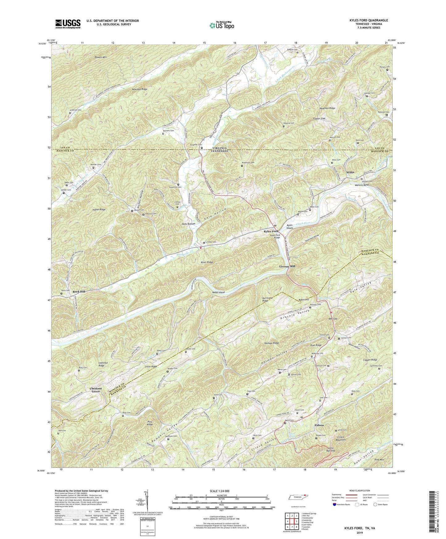
2022 topographic map quadrangle Kyles Ford in the states of Tennessee, Virginia. Scale: 1:24000. Based on the newly updated USGS 7.5' US Topo map series, this map is in the following counties: Hancock, Hawkins, Lee. The map contains contour data, water features, and other items you are used to seeing on USGS maps, but also has updated roads and other features. This is the next generation of topographic maps. Printed on high-quality waterproof paper with UV fade-resistant inks.
Quads adjacent to this one:
West: Sneedville
Northwest: Hubbard Springs
North: Ben Hur
Northeast: Stickleyville
East: Looneys Gap
Southeast: Burem
South: Camelot
Southwest: Lee Valley
Contains the following named places: Amyx Cemetery, Anderson Cemetery, Anderson School, Baker Cemetery, Baker Hill, Beech Grove Church, Belcher Cemetery, Bend Branch, Black Sheep Hollow, Blackwater Creek, Blackwater Union Church, Bledsoe Cemetery, Bloomer Cemetery, Bray Cemetery, Brooks Cemetery, Burgener Cemetery, Chestnut Grove, Chestnut Grove School, Clinch Valley Volunteer Fire Department Station 1, Clinch View School, Commissioner District 4, Compromise Church, Cope Cemetery, Copper Ridge, Couch Cemetery, Davis Branch, Davis Cemetery, Davis Chapel, Davis Chapel School, Delp Cemetery, Ealy Hollow, East Fork Blackwater Creek, Eidson, Eidson Post Office, Eidson School, Eidson Spring, Fletcher Cemetery, Flower Gap, Flower Gap Church, Flower Gap School, Fox Branch, Fox Branch Church, Fox Branch School, Frog Level, Gonce Cemetery, Grassy Springs Church, Grassy Springs School, Gravely Valley, Helton Hollow, Holman Ridge, Holman Valley, Huey Bottom, Hurd Cemetery, Hurricane Ridge, Indian Ridge, Jaynes Cemetery, Johnson Cemetery, Kinsler Cemetery, Kyles Ford, Kyles Ford Baptist Church, Kyles Ford Bridge, Kyles Ford Division, Kyles Ford Elementary School, Kyles Ford Post Office, Kyles Shoals, Lawson Cemetery, Little Creek, Little Ridge, Little War Gap, Livesay Cemetery, Livesay Mill, Livesay School, Lonesome Pine School, Machine Branch, Manis Cemetery, Marcum Cemetery, Marions View Church, Markham Cemetery, McKinney Cemetery, McMillian Cemetery, Mill Creek, Nattie Branch, Neely Cemetery, Newman Ridge, Nichols Hollow, North Fork Clinch River, Osborne Cemetery, Panther Creek Volunteer Fire Department, Parsons Cemetery, Pine Ridge, Pratt Branch, Pridemore Cemetery, Quillen Cemetery, Riley Cemetery, River Ridge, Robertson Branch, Robinson Cemetery, Rock Hill, Rock Hill School, Sandy Branch, Sarepta Church, Sarepta School, Seal Cemetery, Sizemore Cemetery, Sweet Branch, Sweet Creek, Tate Cemetery, Testerman Cemetery, Testerman Hollow, Trent Cemetery, Turkey Creek, Unicoi Church, Unicoi School, Union Hill Church, Union School, Vaughn Cemetery, Vaughns School, Wallen Cemetery, Wallens Bend, Wallens Bend Church, Wallens Bend School, War Gap, Webb Island, Weston Cemetery, Wheatbread Hollow, Williams Cemetery, Willis, Willis Cemetery, Willis School, Yellow Spring, ZIP Codes: 37731, 37765