MyTopo
Caney Creek Tennessee US Topo Map
Couldn't load pickup availability
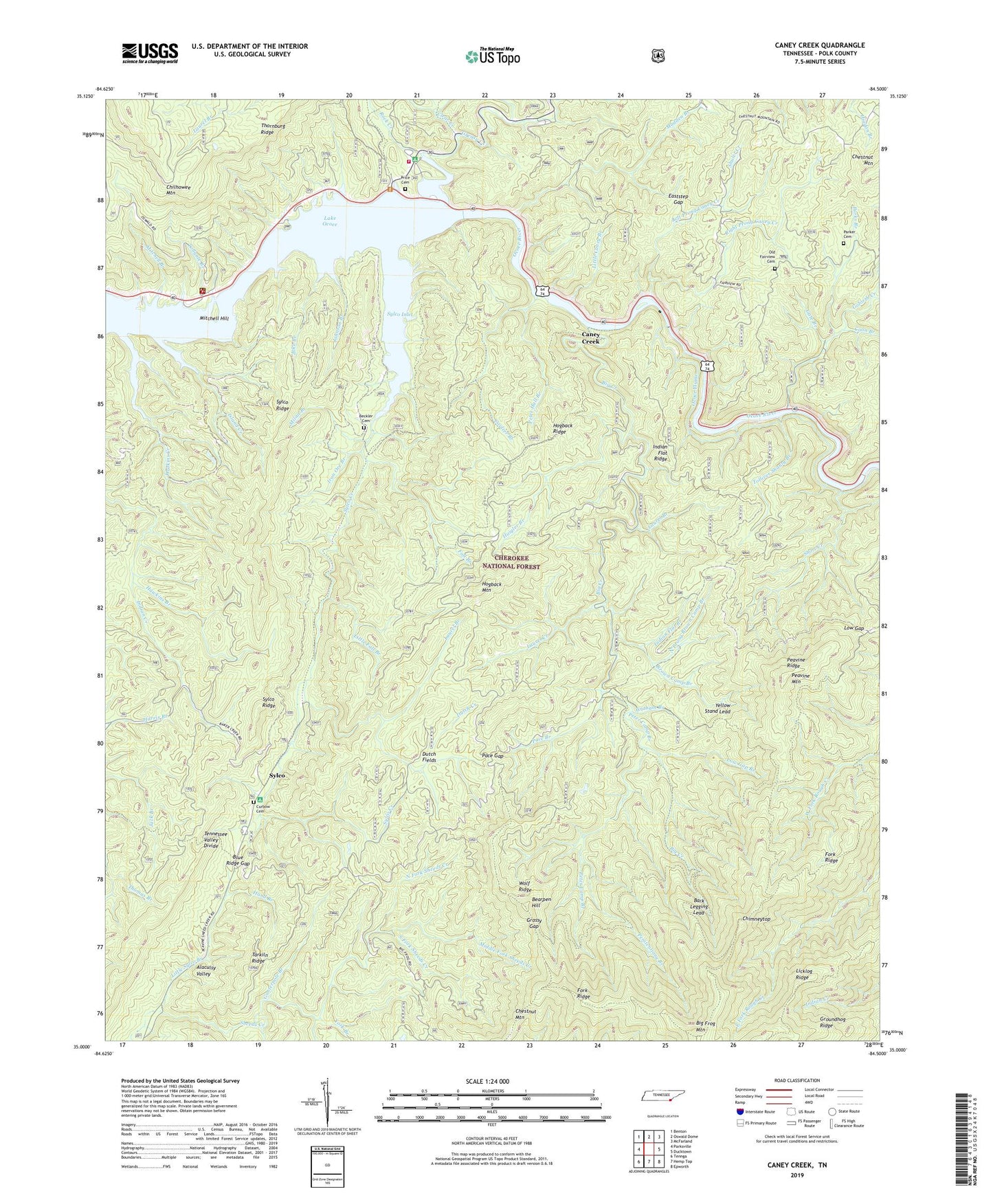
2019 topographic map quadrangle Caney Creek in the state of Tennessee. Scale: 1:24000. Based on the newly updated USGS 7.5' US Topo map series, this map is in the following counties: Polk. The map contains contour data, water features, and other items you are used to seeing on USGS maps, but also has updated roads and other features. This is the next generation of topographic maps. Printed on high-quality waterproof paper with UV fade-resistant inks.
Quads adjacent to this one:
West: Parksville
Northwest: Benton
North: Oswald Dome
Northeast: McFarland
East: Ducktown
Southeast: Epworth
South: Hemp Top
Southwest: Tennga
Contains the following named places: Bark Legging Lead, Bearpen Hill, Beckler Cemetery, Big Creek, Big Creek Trail, Big Frog Mountain, Big Frog Trail, Big Frog Wilderness, Blue Ridge Gap, Blue Ridge School, Blue Ridge Trail, Brown Camp Branch, Camp Cherokee Organization Camp, Caney Creek, Caney Creek Trail, Chable, Chestnut Mountain, Chestnut Mountain Trail, Chimneytop, Civilian Conservation Corps Camp Number 1451, Civilian Conservation Corps Camp Number 1452, Clear Creek, Commissioner District 2, Coon Branch, Coon Creek, Coulter Branch, Curbow Cemetery, Dutch Creek, Dutch Fields, Eaststep Gap, Fairview Church, Fairview School, Fall Branch, Fork Ridge, Fork Ridge Trail, Gate Branch, Goforth Creek, Graham Branch, Grassy Gap, Grassy Gap Trail, Greasy Creek, Groundhog Ridge, Gunterpole Branch, Haigler Branch, Hand Branch, Haskins Creek, Haskins Ford, Hawkins Branch, Hogback Mountain, Hogback Ridge, Hogback Trail, Indian Flat Branch, Indian Flat Ridge, Indian Flat Trail, Iron Ore Branch, Island Creek, Jake Branch, Johnson Branch, Lake Ocoee, Laurel Branch, Laurel Creek, Left Prong Caney Creek, Licklog Ridge Trail, Little Caney Branch, Little Fall Branch, Little Sylco Branch, Low Gap, Low Gap Branch, Low Gap Trail, Mac Point Recreation Area, Madden Branch, McCroy 4-H Camp, Middle Fork Sheeds Creek, Milan Branch, Mitchell Branch, Mitchell Hill, North Fork Sheeds Creek, North Prong Brown Camp Branch, Ocoee Flume, Ocoee Power Plant Number Two, Ocoee Ranger Station, Ocoee Wildlife Management Area, Ocoee Work Center, Old Fairview Cemetery, Pace Branch, Pace Gap, Parker Cemetery, Parks Branch, Parksville Boat Ramp, Parksville Lake Observation Site, Parksville Lake Recreation Area, Peavine Mountain, Peavine Ridge, Penitentiary Branch, Peter Camp Branch, Peter Hall Branch, Polk County, Price Cemetery, Right Prong Caney Creek, Rock Creek, Rough Creek Trail, Sheeds Creek Checking Station, Short Creek, South Fork Sheeds Creek, Sylco, Sylco Campground, Sylco Creek, Sylco Creek Trail, Sylco Inlet, Sylco Ridge, Tarkiln Ridge, Tennessee Valley Authority Boating Site, Thornburg Ridge, Thornburg Shooting Range, Tollgate Branch, Tolliver Shanty Branch, United States Forest Service Ocoee Work Center, United States Forest Service Ranger Station, Wildcat Branch, Wolf Ridge, Wolf Ridge Trail, Yellow Stand Lead, York Branch