MyTopo
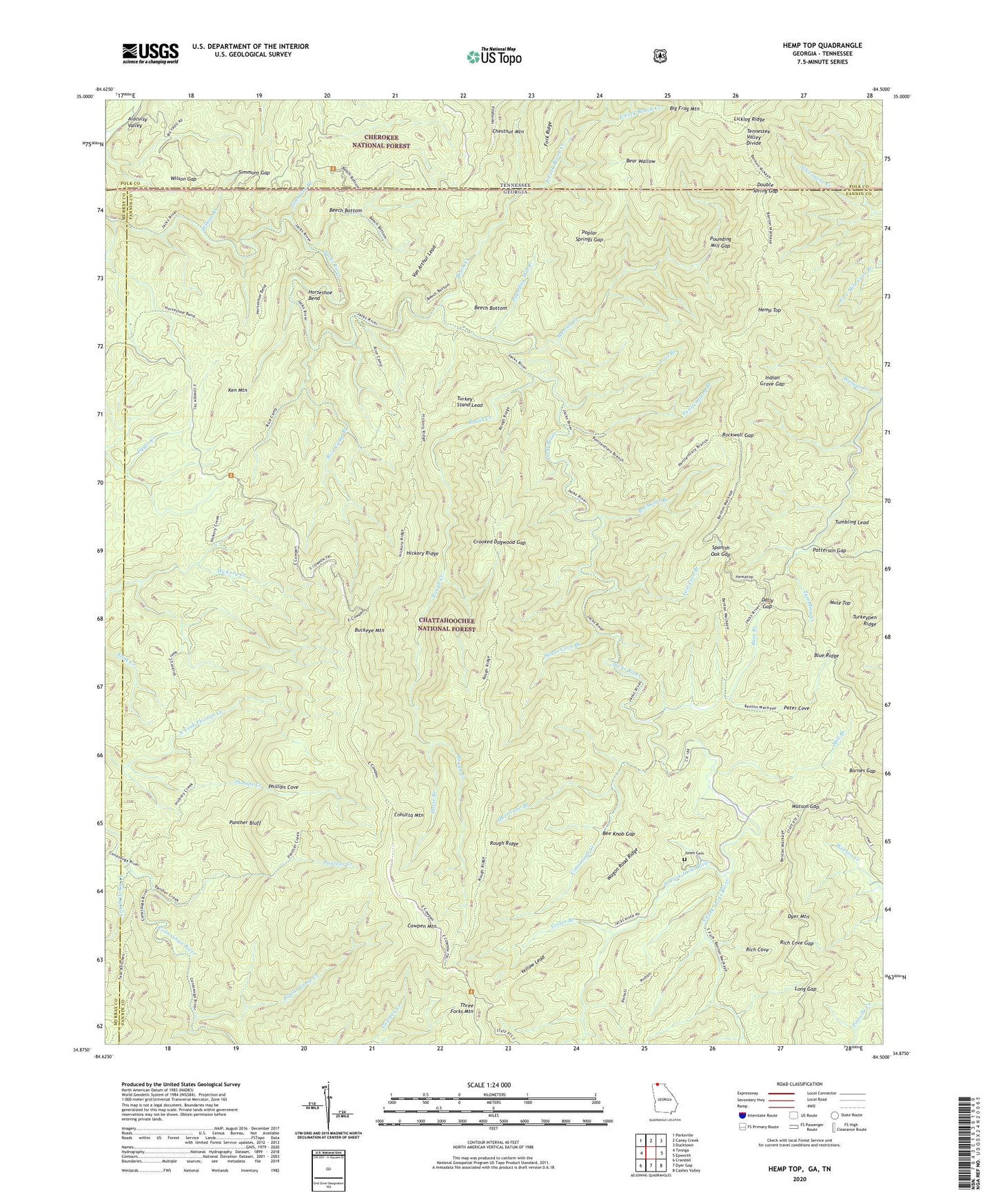
Hemp Top Georgia US Topo Map
Couldn't load pickup availability
Also explore the Hemp Top Forest Service Topo of this same quad for updated USFS data
2024 topographic map quadrangle Hemp Top in the states of Georgia, Tennessee. Scale: 1:24000. Based on the newly updated USGS 7.5' US Topo map series, this map is in the following counties: Fannin, Polk, Murray. The map contains contour data, water features, and other items you are used to seeing on USGS maps, but also has updated roads and other features. This is the next generation of topographic maps. Printed on high-quality waterproof paper with UV fade-resistant inks.
Quads adjacent to this one:
West: Tennga
Northwest: Parksville
North: Caney Creek
Northeast: Ducktown
East: Epworth
Southeast: Cashes Valley
South: Dyer Gap
Southwest: Crandall
Contains the following named places: Barnes Gap, Bear Branch, Bear Wallow, Bee Knob Gap, Beech Bottom, Beech Bottom Trail, Beech Creek, Benton McKaye Trail, Bethlehem Church, Buckeye Mountain, Cohutta Wilderness, Cohutta Wildlife Management Area, Conasauga Creek, Conasauga River Trail, Cowpen Mountain, Crooked Dogwood Gap, Dally Gap, Double Spring Gap, Dyer Mountain, East Cowpen Trail, East Fork Beach Creek, East Fork Beech Creek, Foster Branch, Hemp Top, Hemp Top Trail, Hickory Creek Trail, Hickory Ridge, Hickory Ridge Trail, Higdon-Mobile Division, Horse Branch, Horseshoe Bend, Horseshoe Bend Trail, Hurricane Branch, Indian Grave Gap, Jacks River Trail, Jones Cemetery, Jones Mill, Ken Mountain, Licklog Ridge, Long Gap, Lost Branch, Lost Cove Branch, Mill Branch, Mule Top, Murray Creek, North Fork Thomas Creek, Panther Bluff, Panther Creek, Panther Creek Trail, Patterson Gap, Penitentiary Branch, Penitentiary Branch Trail, Peter Cove, Phillips Cove, Poplar Camp Creek, Poplar Springs Gap, Pounding Mill Branch, Pounding Mill Gap, Rice Camp Branch, Rice Camp Trail, Rich Cove, Rich Cove Gap, Rockwall Branch, Rockwall Gap, Rough Creek, Rough Ridge, Rough Ridge Trail, Simmons Branch, Simmons Gap, South Fork Jacks River, South Fork Trail, Spanish Oak Gap, Sugar Cove Branch, Sugar Cove Trail, Tearbritches Creek, Tearbritches Trail, Three Forks Mountain, Turkey Stand Lead, Van Arthur Lead, Wagon Road Ridge, Walnut Creek, Watson Gap, West Fork Beech Creek, West Fork Jacks River, Wilson Branch, Wilson Gap, Yellow Lead, ZIP Code: 30541