MyTopo
Centerville Tennessee US Topo Map
Couldn't load pickup availability
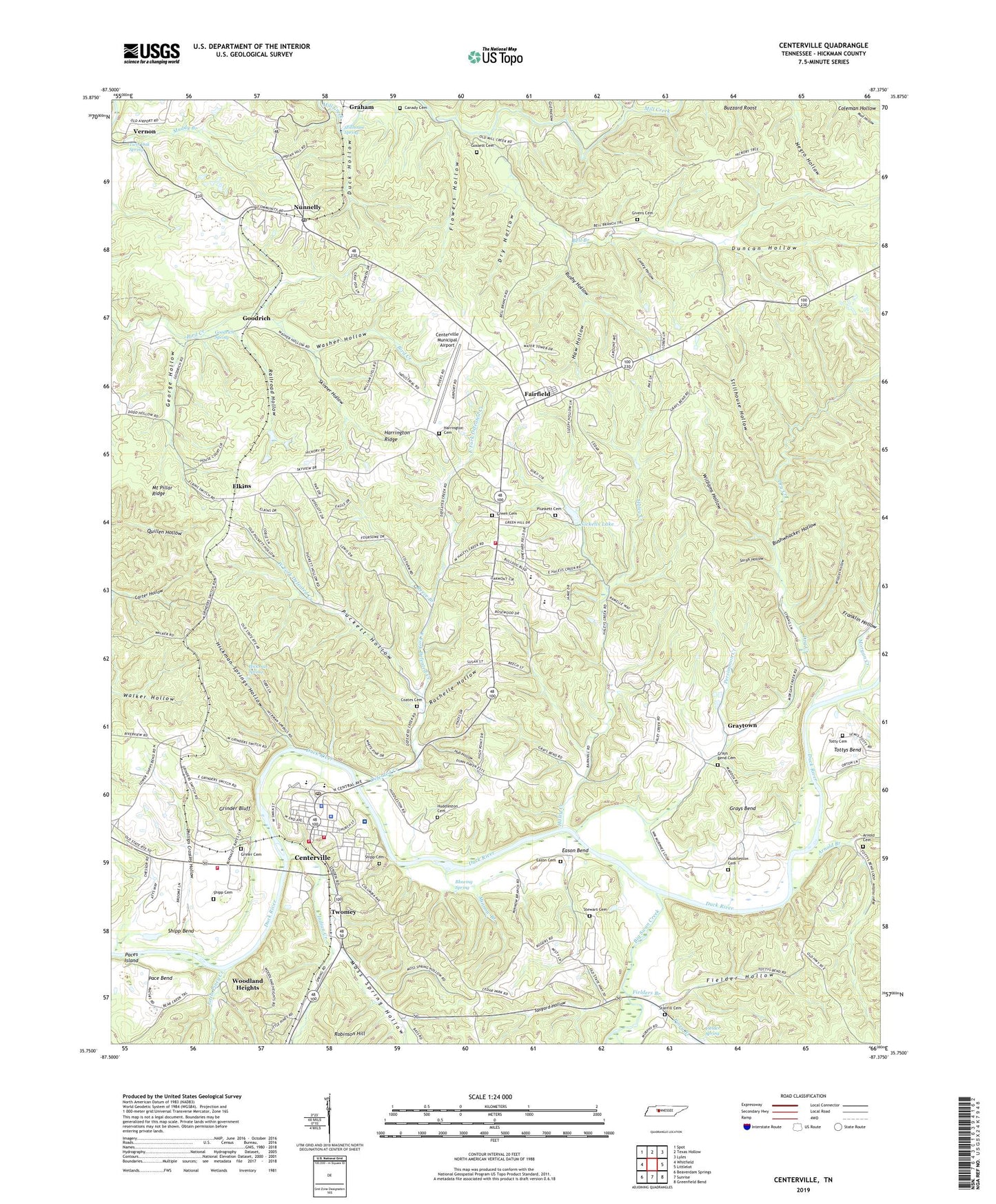
2022 topographic map quadrangle Centerville in the state of Tennessee. Scale: 1:24000. Based on the newly updated USGS 7.5' US Topo map series, this map is in the following counties: Hickman. The map contains contour data, water features, and other items you are used to seeing on USGS maps, but also has updated roads and other features. This is the next generation of topographic maps. Printed on high-quality waterproof paper with UV fade-resistant inks.
Quads adjacent to this one:
West: Whitfield
Northwest: Spot
North: Texas Hollow
Northeast: Lyles
East: Littlelot
Southeast: Greenfield Bend
South: Sunrise
Southwest: Beaverdam Springs
This map covers the same area as the classic USGS quad with code o35087g4.
Contains the following named places: Arnold Branch, Arnold Cemetery, Bell Branch, Bell Branch School, Bernard School, Big Swan Creek, Blowing Spring, Bushwhacker Hollow, Buzzard Roost, Canady Cemetery, Centerville, Centerville Division, Centerville Elementary School, Centerville Fire Department Station 3, Centerville First Baptist Church, Centerville Golf and Country Club, Centerville Municipal Airport, Centerville Police Department, Centerville Post Office, Centerville Volunteer Fire Department Main Station, Centerville Volunteer Fire Department Station 2, Civilian Conservation Corps Camp Number 1468, Coates Cemetery, Commissioner District 6, Conley Hollow, Defeated Creek, Defeated Creek School, Dry Creek, Dry Hollow, Duck Hollow, Duncan Hollow, Easley Mines, Eason Bend, Eason Cemetery, East Fork Defeated Creek, Elkins, Fairfield, Fairfield Baptist Church, Fielder Hollow, Fielder Spring, Fielders Branch, Flowers Hollow, Franklin Hollow, George Hollow, Gid Hollow, Givens Cemetery, Goodrich, Goodrich Spring, Gossett Cemetery, Graham, Grays Bend, Grays Bend Cemetery, Graytown, Green Cemetery, Grinder Bluff, Grinders Switch, Griner Cemetery, Haley Creek, Haleys Creek School, Harrington Cemetery, Harrington Ridge, Haw Hollow, Hickman County, Hickman County Ambulance Service, Hickman County Courthouse, Hickman County Fairgrounds, Hickman County Farm, Hickman County High School, Hickman County Middle School, Hickman County Rescue Squad Station 1, Hickman County Sheriff's Department, Hickman Spring, Hickman Springs Hollow, Hub Hollow, Huddleston Cemetery, Indian Creek, Johnson Mines, Little Piney Creek, Minnow Branch, Moores Switch, Moores Switch Lookout Tower, Morgan Creek, Moss Spring Hollow, Myer Hollow, Nickells Dam, Nickells Lake, Nunnelly, Nunnelly Mines, Nunnelly Post Office, Nunnelly School, Paces Island, Persimmon Creek, Phillips Crossing Hollow, Piney Branch, Plunkett Cemetery, Puckett Hollow, Railroad Hollow, Reece Branch, Rochelle Hollow, Rushy Hollow, Saint Thomas Hickman Hospital, Sarah Hollow, Shipp Bend Church, Shipp Cemetery, Shipps Bend School, Skinner Hollow, Stanfill Cemetery, Stanfill School, Stewart Cemetery, Stillhouse Hollow, Stillhouse Spring, Tanyard Hollow, Tennessee Department of Agriculture Division of Forestry Hickman Fire Tower, Totty Cemetery, Town of Centerville, Twin Oak Spring, Twomey, Vernon, Washer Hollow, West Fork Defeated Creek, WHLP-AM (Centerville), Wildcat Hollow, Williams Hollow, Woodland Heights, Woodland Heights School