MyTopo
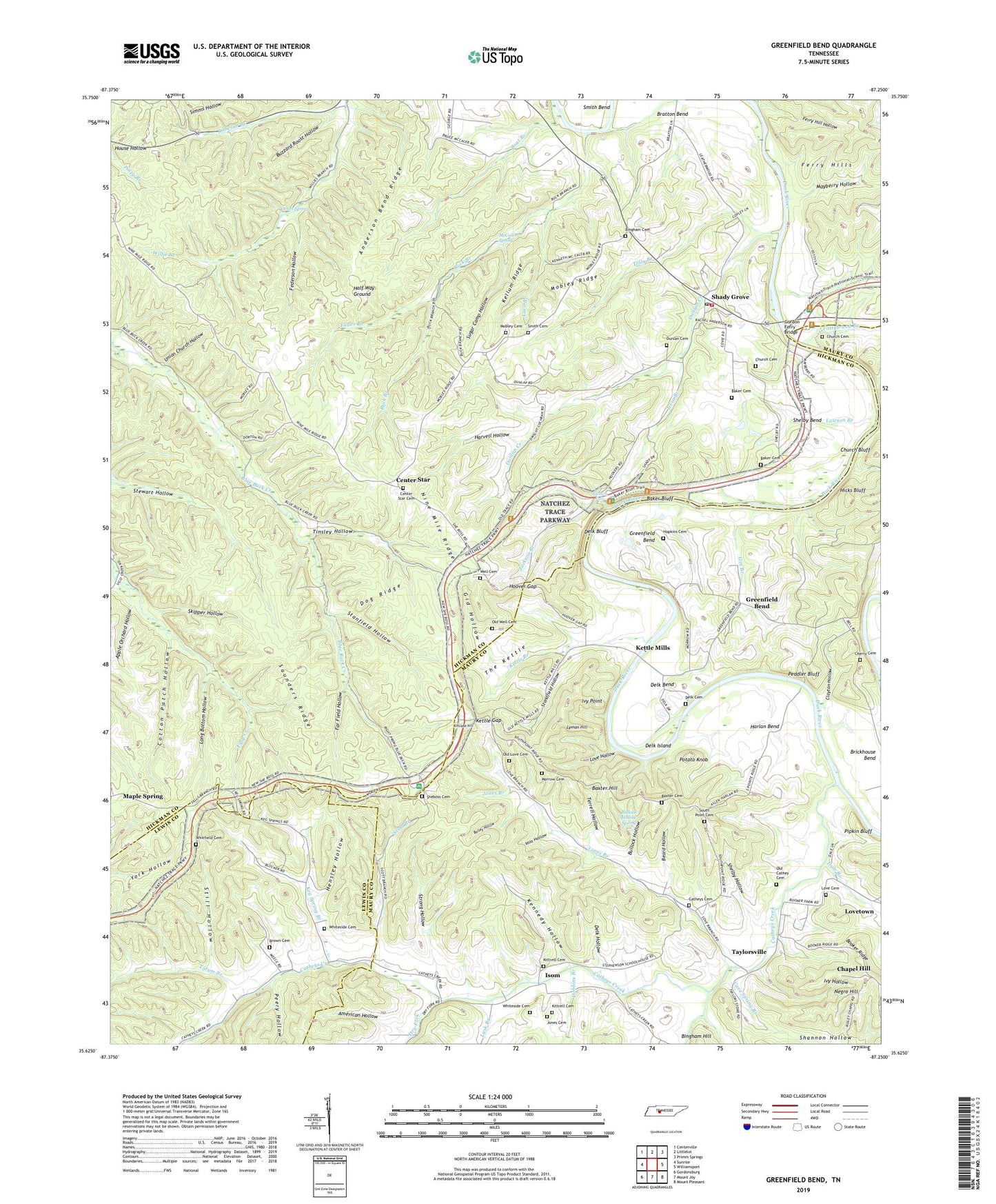
Greenfield Bend Tennessee US Topo Map
Couldn't load pickup availability
2022 topographic map quadrangle Greenfield Bend in the state of Tennessee. Scale: 1:24000. Based on the newly updated USGS 7.5' US Topo map series, this map is in the following counties: Hickman, Maury, Lewis. The map contains contour data, water features, and other items you are used to seeing on USGS maps, but also has updated roads and other features. This is the next generation of topographic maps. Printed on high-quality waterproof paper with UV fade-resistant inks.
Quads adjacent to this one:
West: Sunrise
Northwest: Centerville
North: Littlelot
Northeast: Primm Springs
East: Williamsport
Southeast: Mount Pleasant
South: Mount Joy
Southwest: Gordonsburg
This map covers the same area as the classic USGS quad with code o35087f3.
Contains the following named places: Air Rock Church, Air Rock School, American Hollow, Anderson Bend Ridge, Apple Orchard Hollow, Bailey Hollow, Baker Bluff, Baker Cemetery, Baker Slough, Baxter Cemetery, Baxter Hill, Beard Hollow, Bethel Church, Bethel School, Bingham Cemetery, Boat Branch, Bratton Bend, Brickhouse Bend, Brown Cemetery, Buck Branch, Bullock Hollow, Bullock Hollow Spring, Buzzard Roost Hollow, Catheys Cemetery, Catheys Creek, Catheys Creek Church, Cave Branch, Cave Spring Branch, Center Star, Center Star Cemetery, Center Star Church, Center Star School, Chapel Hill, Chapel Hill School, Cherry Cemetery, Church Bluff, Church Cemetery, Clayton Hollow, Cotton Patch Hollow, Curry Branch, Dale Branch, Delk Bend, Delk Bluff, Delk Cemetery, Delk Ford, Delk Hollow, Delk Island, Dobbins Branch, Dog Ridge, Dry Fork, Duck River Post Office, Dunlan Cemetery, Dunlap Creek, Far Field Hollow, Fattybread Branch, Federson Hollow, Ferry Hill Hollow, Ferry Hills, Forty Thicket School, Fuller Branch, Gid Hollow, Gin Branch, Gordon Ferry, Gordon Ferry Bridge, Graham School, Greenfield Bend, Greenfield Bend Church of Christ, Half Way Ground, Hampshire Creek, Harlan Bend, Harvell Hollow, Hensley Hollow, Hicks Bluff, Hoover Gap, Hopkins Cemetery, Irvin Branch, Isom, Ivy Hollow, Ivy Point, Jackson Branch, Jackson Falls, Jones Branch, Jones Cemetery, Jones Presbyterian Church, Keg Spring Branch, Kellum Ridge, Kennedy Hollow, Kettle Branch, Kettle Church, Kettle Gap, Kettle Mills, Kincade Hill, Kittrell Cemetery, Lawson Branch, Liberty Church, Long Bottom Hollow, Love Cemetery, Love Hollow, Loves Branch, Lovetown, Lusk Branch, Lyman Hill, Maple Spring, Mars Hill Church, Mayberry Hollow, McCaleb Spring, Mobley Cemetery, Mobley Ridge, Morrow Cemetery, Negro Hill, Nine Mile Ridge, Old Cathey Cemetery, Old Love Cemetery, Old Well Cemetery, Orton Spring, Peddler Bluff, Peery Hollow, Pipkin Bluff, Pleasant Union Church, Pleasant Union School, Potato Knob, Robeson Branch, Saunders Ridge, Scott Branch, Shady Grove, Shady Grove School, Shady Grove Volunteer Fire Department, Shannon Hollow, She Boss Church, Sheboss Cemetery, Sheboss Place, Shelby Bend, Shelby Hollow, Skipper Hollow, Smith Cemetery, South Point Cemetery, South Point Church, Standfield Hollow, Stanfield Hollow, Stephens School, Still Hollow, Strong Hollow, Sugar Camp Hollow, Tatum Branch, Taylorsville, Terrell Hollow, The Hairpin, The Kettle, Tinsley Hollow, Tolly Branch, Totty Branch, Union Church, Union Church Hollow, Voss Hollow, Weatherly Lookout Tower, Well Cemetery, Whiteside Cemetery, Whitfield Cemetery, ZIP Code: 38454