MyTopo
Cheatham Dam Tennessee US Topo Map
Couldn't load pickup availability
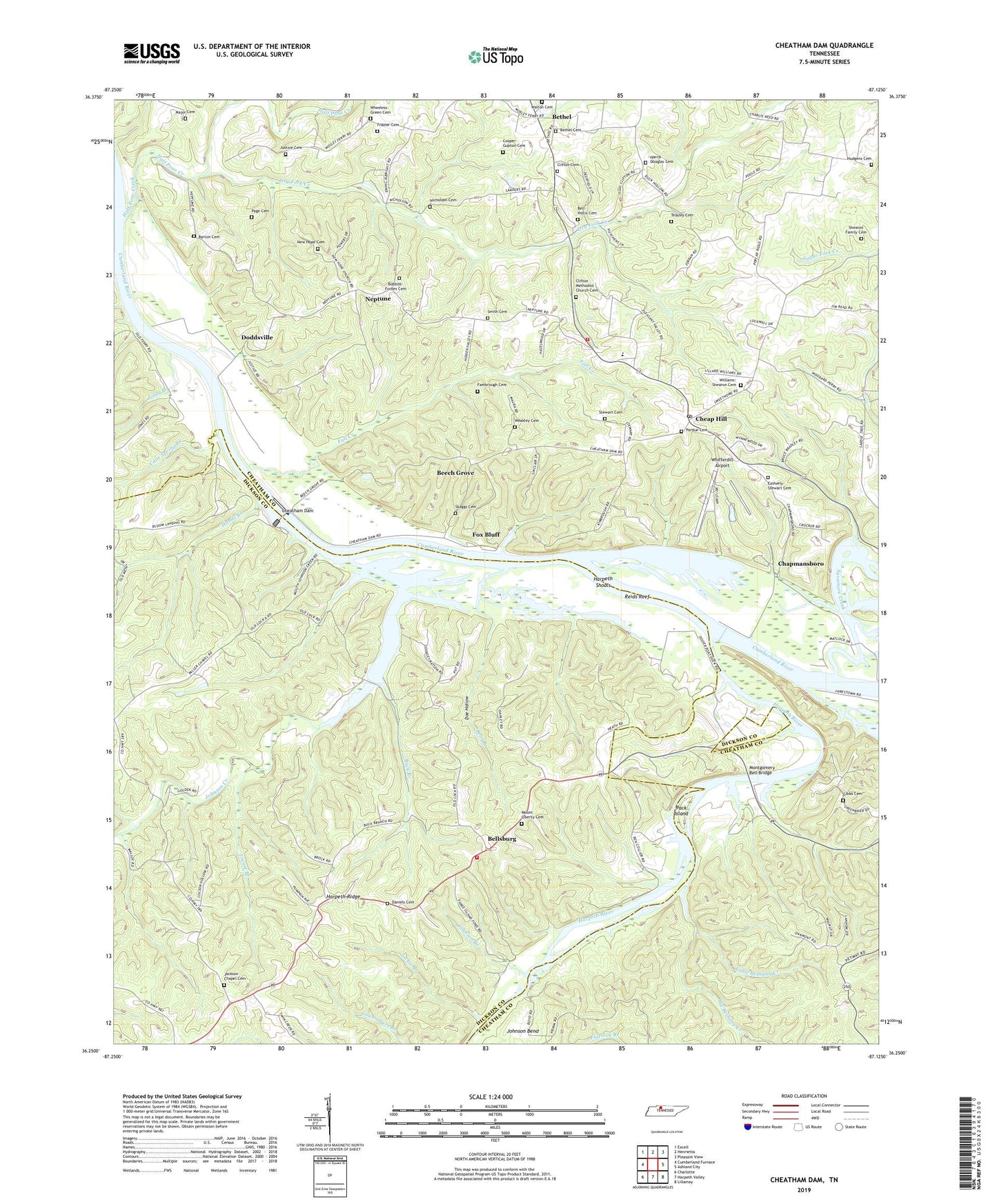
2022 topographic map quadrangle Cheatham Dam in the state of Tennessee. Scale: 1:24000. Based on the newly updated USGS 7.5' US Topo map series, this map is in the following counties: Cheatham, Dickson. The map contains contour data, water features, and other items you are used to seeing on USGS maps, but also has updated roads and other features. This is the next generation of topographic maps. Printed on high-quality waterproof paper with UV fade-resistant inks.
Quads adjacent to this one:
West: Cumberland Furnace
Northwest: Excell
North: Henrietta
Northeast: Pleasant View
East: Ashland City
Southeast: Lillamay
South: Harpeth Valley
Southwest: Charlotte
This map covers the same area as the classic USGS quad with code o36087c2.
Contains the following named places: Antioch Church, Barton Cemetery, Baxters Landing, Bear Branch, Beech Grove, Bell - Hollis Cemetery, Bellsburg, Bellsburg School, Bethel, Bethel Church, Bethel Church Cemetery, Bethel Freewill Baptist Church, Bethel School, Betsystown, Betsystown Landing, Big Bethany Creek, Bobbitt-Forbes Cemetery, Buck Branch, Cave Spring Branch, Chapmansboro, Chapmansboro Post Office, Cheap Hill, Cheap Hill Church of Christ, Cheatham Dam, Cheatham Damsite Access Area, Cheatham Damsite Tailwater Access Point, Cheatham Lake, Clifton Cemetery, Clifton Church, Commissioner District 4, Cooper Gupton Cemetery, Currents Landing, Daniels Cemetery, Doddsville, Doe Hollow, Doubledays Landing, Dozier, Dry Fork Creek, Dyson Ditch Wildlife Refuge, Eatherly - Stewart Cemetery, Edwards Landing, Fall Creek, Fambrough Cemetery, Fambroughs Landing, Fox Bluff, Frazier Cemetery, Gibbs Cemetery, Half Pone Creek, Hands Branch, Harpeth Ferry, Harpeth Ridge, Harpeth Ridge Volunteer Fire Department, Harpeth River, Harpeth River Bridge Access Point, Harpeth Shoals, Harris - Douglas Cemetery, Hegwood Landing, Henrietta Volunteer Fire Department Station 2, Hinton Crossing, Hudgens Cemetery, Indian Ford, Jackie Branch, Jackson Chapel, Jackson Chapel Cemetery, Jackson Chapel Methodist Church, Jackson Chapel School, Johnson Branch, Johnson Creek, Jones Branch, Justice Cemetery, Little Bethany Creek, Lock A, Lock A Recreation Area, Locust Branch, Major Cemetery, Mayberry Branch, Mayberry Branch Access Park, Millers Chapel Freewill Baptist Church, Millers Chapel School, Montgomery Bell Bridge, Mount Liberty Cemetery, Mount Liberty Church, Mount Zion Church, Neptune, Neptune - Smith Cemetery, Neptune United Methodist Church, New Hope Cemetery, Newtons Landing, Nicholson Cemetery, Pack Island, Page Cemetery, Pardue, Pardue Cemetery, Pardue Pond Wildlife Refuge, Pardues Landing, Pardues Wood Yard, Pflaster - Clifton Cemetery, Reids Reef, Rowerths Landing, Shearon Family Cemetery, Skaggs Cemetery, Stewart Cemetery, Stones Landing, Sycamore Creek, Teasley Cemetery, Walton Cemetery, Weakley Cemetery, Wheeless-Green Cemetery, Whifferdill Airport, Whirl Pool Landing, Williamsons Cribs, Williams-Shearon Cemetery