MyTopo
Leatherwood Tennessee US Topo Map
Couldn't load pickup availability
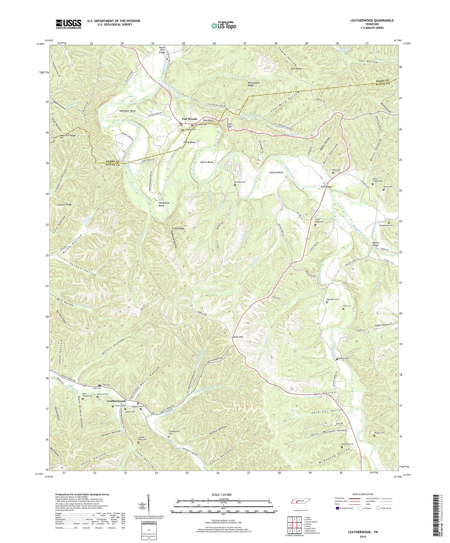
2022 topographic map quadrangle Leatherwood in the state of Tennessee. Scale: 1:24000. Based on the newly updated USGS 7.5' US Topo map series, this map is in the following counties: Wayne, Perry. The map contains contour data, water features, and other items you are used to seeing on USGS maps, but also has updated roads and other features. This is the next generation of topographic maps. Printed on high-quality waterproof paper with UV fade-resistant inks.
Quads adjacent to this one:
West: Clifton
Northwest: Pope
North: Linden
Northeast: Graves Spring
East: Topsy
Southeast: Waynesboro East
South: Waynesboro
Southwest: Eagle Creek
This map covers the same area as the classic USGS quad with code o35087d7.
Contains the following named places: Ann Homer, Apple Orchard Hollow, Barnes Graves, Bartley Bridge, Bastin Bend, Battles Hollow, Bawcom Cemetery, Beech Creek Volunteer Fire Department, Bell Bridge, Bell Cemetery, Bell Hollow, Bells Ford, Big Opossum Creek, Big Rock Ford, Boldin Hollow, Bridge Branch, Bromley Branch, Bromley Cemetery, Bromley Ford, Brushy Hollow, Buck Branch, Bunch Ford, Burns Cemetery, Burns Hollow, Canoe Branch, Chalk Hollow, Chappell Cemetery, Chappell Methodist Church, Choate Bend, Choate Branch, Cold Water Branch, Commissioner District 3, Cove Hollow, Cow Mire Hollow, Crossno Ridge, Dabbs Hollow, Davis Hollow, Defoe Camp, Dry Branch, Farmer Hollow, Flat Woods, Flat Woods Lookout Tower, Flatwoods Cemetery, Flatwoods Post Office, Flatwoods School, Flatwoods Volunteer Fire Department, Goose Coop, Green River, Highland Church, Holt Cemetery, Holt Family Cemetery, Horseshoe Bend, Jack Hollow, Jack Lot Hollow, Lacher Ford, Leatherwood, Leatherwood Branch, Lee Branch, Left Prong Smith Branch, Little Hope Cemetery, Little Opossum Creek, Lovie, Low Gap, Mayberry School, McClaren Hollow, McDonald Cemetery, McDonald Hollow, Merideth Cemetery, Mill Hollow, Old Union Church, Opossum Creek Ford, Parker Cemetery, Phillips Cemetery, Phillips Chapel, Phillips School, Pigg Branch, Pine Bluff, Pitts Cemetery, Pope Branch, Pope Chapel, Pope School, Popes Chapel Cemetery, Pulley Hollow, Right Prong Smith Branch, Riley Hollow, Rochouse Hollow, Rye Patch Hollow, Slink Shoals Ford, Smith Branch, Smith Hill, Sol Hollow, Stock Hollow, Stone Bend, Stone Ridge, Throgmorton Cemetery, Tole Cemetery, Toll Hollow, Toll Hollow Spring, Turnbo Hollow, Whitaker Bend, Whitehead Cemetery, Whitehead Ridge, William Riley Cemetery, Worley Cemetery