MyTopo
Olivehill Tennessee US Topo Map
Couldn't load pickup availability
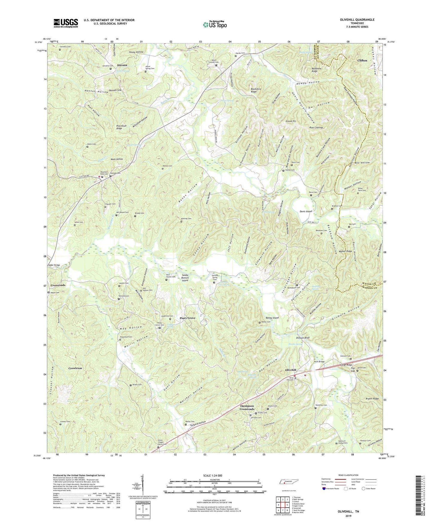
2022 topographic map quadrangle Olivehill in the state of Tennessee. Scale: 1:24000. Based on the newly updated USGS 7.5' US Topo map series, this map is in the following counties: Hardin, Wayne. The map contains contour data, water features, and other items you are used to seeing on USGS maps, but also has updated roads and other features. This is the next generation of topographic maps. Printed on high-quality waterproof paper with UV fade-resistant inks.
Quads adjacent to this one:
West: Hookers Bend
Northwest: Thurman
North: Bath Springs
Northeast: Clifton
East: Eagle Creek
Southeast: Martins Mills
South: Wolf Pit Ridge
Southwest: Savannah
This map covers the same area as the classic USGS quad with code o35088c1.
Contains the following named places: Akins Branch, Altum Spring Cemetery, Arch Bridge, Ashworth Hollow, Backbone Ridge, Bailey Cemetery, Bailey Island, Banks Hollow, Baugus Branch, Baxter Hollow, Bear Branch, Beckham Cemetery, Beckham Hollow, Bee Hollow, Berry Branch, Bethlehem, Bethlehem Cemetery, Bethlehem School, Bigbee Branch, Blackshire Ridge, Boat Gunwale Hollow, Bolden Spring, Boneyard Hollow, Bowling Branch, Bowling Cemetery, Brashier Branch, Brashier Cemetery, Bratten Hollow, Brooks Cemetery, Bryant Ford, Bumpas Cemetery, Buzzard Cave Hollow, Caney Hollow, Cave Spring, Christian Hollow, Clark Ford, Clausel Hollow, Commissioner District 6, Connelly Cemetery, Copperas Spring, Crossroads, Crossroads School, Crowtexas, Dark Hollow, Davis Cemetery, Davis Hollow, Davis Island, Day Hollow, Day Spring, Dick Hardin Cemetery, Dickey Cemetery, Dickson Bluff, Dillon Farm Cemetery, District 1, District 14, Dowdy Hollow, Dowdy Spring, Duckworth Hollow, Duncan Pond, Eagle Creek, Flat Gap, Flat Gap Creek, Forge Ridge, Franklin Branch, Franks Cemetery, Gant Hollow, Garrard Cave Spring, Garrard Ford, Garrard Spring Cemetery, Gillham Hollow, Gilmore Cemetery, Gilmore Hollow, Gravel Pit, Gravett Branch, Gray Hollow, Hamilton Hollow, Hannah Church, Hannah Hollow, Hannah Sink, Harbour Cemetery, Hardin Branch, Hardin Cemetery, Hardin County Fire Department / Emergency Management District 4 Station 3, Hardin County Fire Department / Emergency Management District 9, Hardin County Fire Department / Emergency Management District 9 Station 1, Hardin Ford, Hardin School, Hardin Spring, Havana, Havana School, Havanna Cemetery, Havanna Church, Henry Hardin Hollow, Hogpen Hollow, Hosey Hollow, Howe Cemetery, Hudiburg Ford, Hudiburg Spring, Hughes Hollow, Hulen Cemetery, Hulin Branch, Jeff Hollow, Jerrolds Cemetery, Joe Hollow, Johnson Ford, Jordan Hollow, Jowers Cemetery, Kincannon Cemetery, King Hollow, Linville Ford, Looney Cemetery, Lovefield Branch, Mag Hollow, Marshall Hollow, Mash Hollow, McCasland Branch, McCasland Cemetery, McCollum Hollow, Mill Hollow, Mill Hollow Cemetery, Morris Hollow, Mount Carmel Cemetery, Mount Carmel Church, Mountain View Cemetery, Mountain View Church, Mountain View School, Northcut Elementary, Northcutt Branch, Norton Hollow, Old Cemetery, Olive Hill Baptist Church, Olive Hill Cemetery, Olive Hill Division, Olive Hill School, Olivehill, Owl Hollow, Panther Branch, Paradise Hollow, Patterson Cemetery, Perry Chapel, Pine Knob Ridge, Piney Grove, Piney Grove Cemetery, Piney Grove Church, Pitts Hollow, Pogue Cemetery, Polk Hollow, Pool Hollow, Porter Ford, Pulley Branch, Reynolds Branch, Reynolds Spring, Rocky Branch, Rose Branch, Rose Hollow, Rose School, Russ Coalings, Sandy Bottom Island, Schoolhouse Hollow, Simmons Branch, Sims Ford, Sims Hollow, Sims Spring, Smith Fork, Smiths Fork, Spear Hollow, Steward Cemetery, Stricklin Hollow, Tanyard Hollow, Thacker Cemetery, Thompson Crossroads, Ticey Hollow, Turkey Hollow, Umphreys Cemetery, Union Chapel, Union Chapel North Cemetery, Wad Hardin Hollow, Walker Hollow, Walker Ridge, Watson Cemetery, White Cemetery, Whitten Ford, Yarbrough Hollow, ZIP Code: 38475