MyTopo
Demory Tennessee US Topo Map
Couldn't load pickup availability
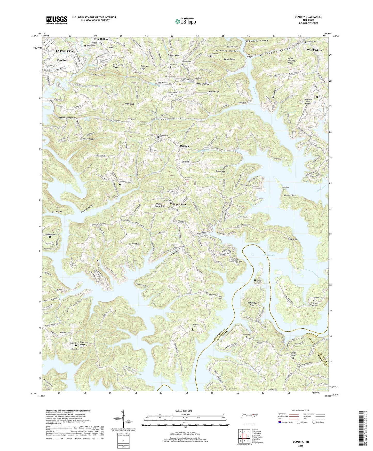
2022 topographic map quadrangle Demory in the state of Tennessee. Scale: 1:24000. Based on the newly updated USGS 7.5' US Topo map series, this map is in the following counties: Campbell, Anderson, Union. The map contains contour data, water features, and other items you are used to seeing on USGS maps, but also has updated roads and other features. This is the next generation of topographic maps. Printed on high-quality waterproof paper with UV fade-resistant inks.
Quads adjacent to this one:
West: Jacksboro
Northwest: Ivydell
North: La Follette
Northeast: Well Spring
East: White Hollow
Southeast: Big Ridge Park
South: Norris
Southwest: Lake City
This map covers the same area as the classic USGS quad with code o36084c1.
Contains the following named places: Agee, Alder Springs, Alder Springs Baptist Church, Alder Springs School, Anderson County Park, Anderson County Sportsmens Club, Andrews Cemetery, Baird Cemetery, Baker Forge Memorial Cemetery, Bald Knob, Big Creek, Big Hollow, Black Cemetery, Blue Spring, Blue Spring Ridge, Bolinger Cemetery, Boshears Tree Farm, Boy, Camp Pellissippi, Campbell County Rural Fire Service Station 3, Campbell County Rural Fire Service Station 4, Cedar Creek, Cedar Creek Baptist Church, Cedar Creek Bridge, Central Peninsula, Chadwell Cemetery, Chestnut Stump Ridge, Commissioner District 1, Coolidge Ridge, Coolidge School, Cove Creek Wildlife Management Area, Custer, Daugherty Cemetery, Deerfield Resort Airport, Demory, Demory Baptist Church, Demory School, East Murrayville Cabin Area, Elbow Hollow, Fordtown, Fork Bend, Four Corners, Gatham Bend, Gaylor Cemetery, Grantsboro, Grantsboro Baptist Church, Grantsboro Cemetery, Grantsboro School, Hatmaker, Hatmaker Cemetery, Heatherly Point Cabin Area, Hicks Cemetery, High Knob, Housley Cemetery, Jones Cemetery, Kitts Cemetery, La Follette Division, Lick Hollow, Little Dividing Ridge, McFarland Hollow, Mill Hollow, Mount Moriah Cemetery, Mount Pleasant United Methodist Cemetery, Mount Pleasant United Methodist Church, Murrayville Baptist Church, Murrayville Cemetery, Negro Ridge, Oak Ridge Yacht Club, Orick Cemetery, Pellissippi Boat Dock, Pellissippi Point, Pellissippi Point Cabin Area, Phillips Branch, Pinecrest Ridge, Pleasant Ridge Church, Pleasant Ridge School, Pond Cemetery, Primroy, Pyles Cemetery, Racetrack Hollow, Rainbow Marina and Resort, Rich Hollow, Robbins Cemetery, Sequoyah Landing, Sequoyah Landing Cabin Area, Sequoyah Marina, Shanghai Branch, Shanghai Dock, Shanghai Resort, Sharp Cemetery, Shepard Cemetery, Shoffner Branch, Star Dust Dock, Stillhouse Hollow, Stokes Cemetery, Stooksbury Cemetery, Sugar Hollow, Sugar Hollow Church, Sutton Cemetery, Sutton Hollow, Sutton Ridge, Sweeten Spring, Sweeten Spring Hollow, Tanbark Knob, Turkey Ridge, Upper Cumberland Council Boy Scout Camp, Walters Cemetery, Water Branch Hollow, Weaver Cemetery, Whitakers Boat Dock, Whitman, Whitman Hollow, Whitman Hollow Boat Dock, Whitman Hollow Church, Willoughby Hollow, Wilson Cemetery, Wolf Hollow, Woodward Cemetery