MyTopo
Doe Tennessee US Topo Map
Couldn't load pickup availability
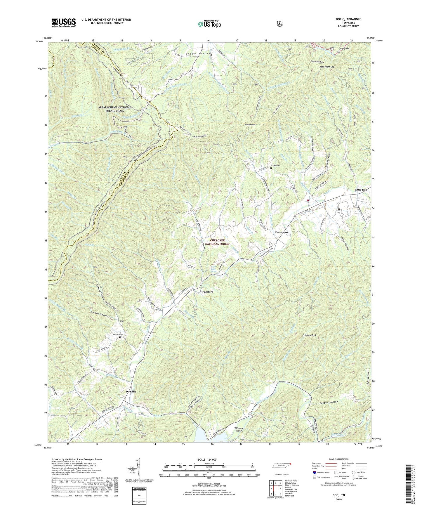
2019 topographic map quadrangle Doe in the state of Tennessee. Scale: 1:24000. Based on the newly updated USGS 7.5' US Topo map series, this map is in the following counties: Johnson, Carter, Sullivan. The map contains contour data, water features, and other items you are used to seeing on USGS maps, but also has updated roads and other features. This is the next generation of topographic maps. Printed on high-quality waterproof paper with UV fade-resistant inks.
Quads adjacent to this one:
West: Carter
Northwest: Holston Valley
North: Shady Valley
Northeast: Laurel Bloomery
East: Mountain City
Southeast: Sherwood
South: Elk Mills
Southwest: Watauga Dam
Contains the following named places: Andy Branch, Arnold Hollow, Bakers Ridge Creek, Battleham Gap, Berry Branch, Bethel Church, Bethel School, Big Spur Branch, Blackburn Prospect, Boone Branch, Buck Ridge, Burnt Spring Ridge, Butler Division, Campbell Cemetery, Campbell Creek, Campbell Hollow, Campbell Mine, Cave Ridge, Charley Ridge, Chimney Rock, Church Ridge, Clyde Ridge, Commissioner District 5, Cook Hollow, Creek Ridge, Damascus, Damascus Church, Doe Creek, Doe Elementary School, Doe Station, Doe Valley Church, Doe Valley Mine, Doe Valley School, Doe Valley Volunteer Fire Department, Doeville, Doeville School, Dugger Branch, Dugger Hollow, Dyson Grove Church, East Fork Dugger Branch, East Fork Slabtown Branch, Fritz School, Grindstaff Prospect, Harbin Branch, Hopper Creek, Horn Branch, Howard Branch, Iron Mountain Shelter, Iron Mountain Trail, Johnson Hollow, Laurel Branch, Lindy Camp Branch, Little Doe, Little Doe Church, Lowe Prospect, Mack Branch, Merry Mountain, Moore Ridge, Morfield Branch, Mount Carmel Church, Northeast Correctional Complex, Old Doe Lookout Tower, Old Road Ridge, Owl Hollow, Palmer Branch, Pandora, Pandora Prospects, Pine Orchard School, Pole Branch, Polly Branch, Potter Hollow, Profitt Prospect, Robinson Branch, Robinson Hollow, Sandy Gap, Shady Gap, Shady Valley, Shoun Branch, Shoun Mine, Sidney Branch, Sink Moountain Prospect, Slabtown Branch, Spear Branch, Spear Branch Prospect, Spice Branch, Spice Branch Prospect, Spruce Branch, Stalcup Branch, Stalcup Prospect, Stout Branch, Stout Prospect, Timothy Branch, Trout Belly Spring, Walker Ridge, Ward Ridge, Water Hollow Branch, West Fork Beaverdam Creek, West Fork Dugger Branch, West Fork Slabtown Branch, White Prospect, William Fleeman Cemetery, Williams Island