MyTopo
Laurel Bloomery Tennessee US Topo Map
Couldn't load pickup availability
Also explore the Laurel Bloomery Forest Service Topo of this same quad for updated USFS data
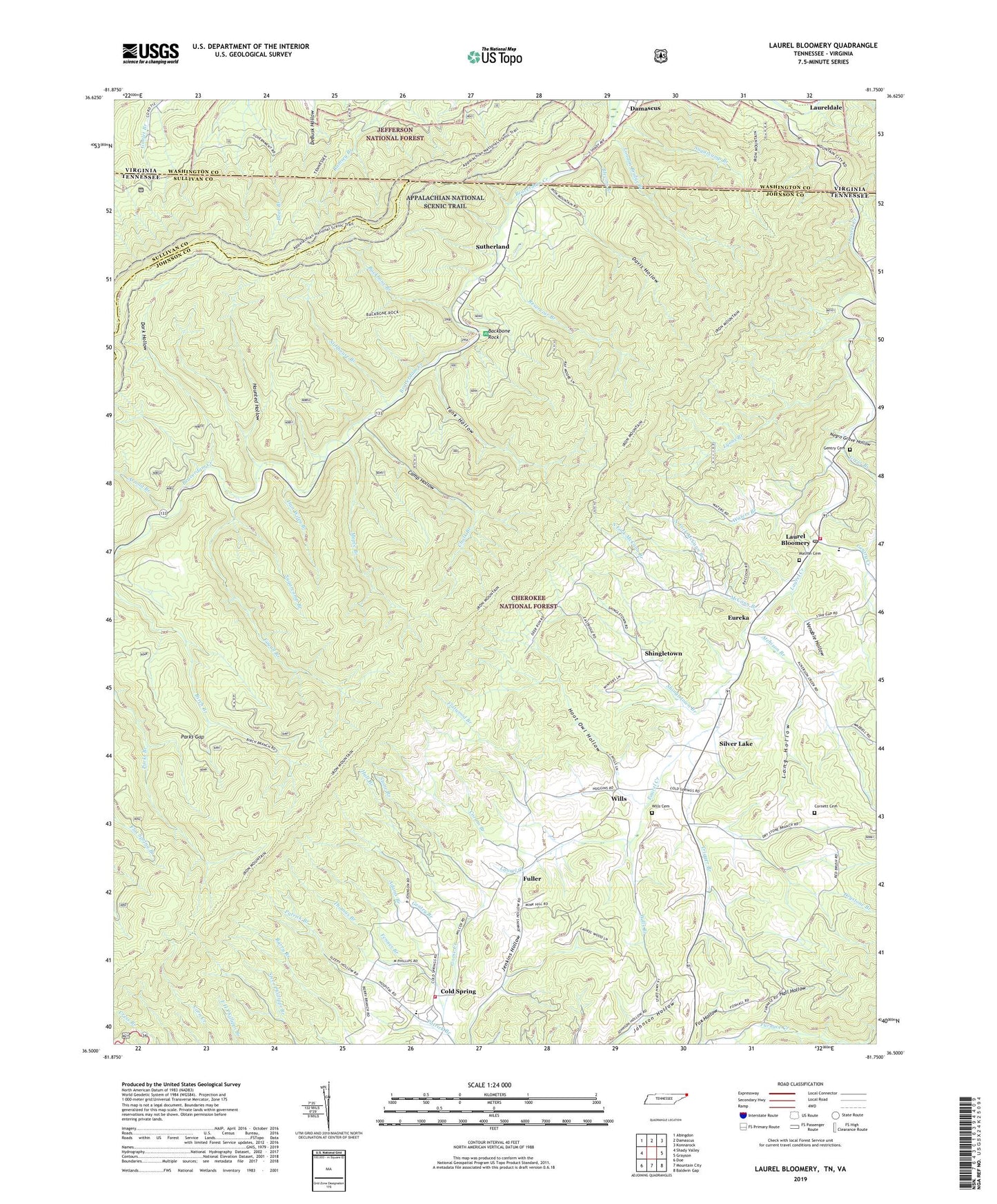
2022 topographic map quadrangle Laurel Bloomery in the states of Tennessee, Virginia. Scale: 1:24000. Based on the newly updated USGS 7.5' US Topo map series, this map is in the following counties: Johnson, Washington, Sullivan. The map contains contour data, water features, and other items you are used to seeing on USGS maps, but also has updated roads and other features. This is the next generation of topographic maps. Printed on high-quality waterproof paper with UV fade-resistant inks.
Quads adjacent to this one:
West: Shady Valley
Northwest: Abingdon
North: Damascus
Northeast: Konnarock
East: Grayson
Southeast: Baldwin Gap
South: Mountain City
Southwest: Doe
Contains the following named places: Adams Branch, Arnold Branch, Atchison Branch, Atchison Church, Atchison School, Backbone Branch, Backbone Rock, Backbone Rock Recreation Area, Blevins Branch, Butt Mountain, Camp A-Hi-S-Ta-Di, Camp Hollow, Camp Hollow Mine, Camp McArthur, Chalk Branch, Chalk Branch Prospect, Cold Spring, Commissioner District 1, Cornett Cemetery, Corum Branch, Dan Wiley Branch, Dark Hollow, Davis Hollow, Dollars Station, Dowe Chapel, Dry Branch, Drystone Branch, East Tank Hollow Prospect, Elliot Branch, Eureka, Fagall Branch, Fairview School, Fenner Branch, First District Volunteer Fire Department, Flatwood Branch, Fox Hollow, Fuller, Garland Ridge, Gentry Branch, Gentry Cemetery, Gentry Creek, Greer Branch, Grindstone Ridge, Hall Branch, Hall Hollow, Haunted Hollow, Hawkins Prospect, Hogback Mine, Hoot Owl Hollow, John Ridge, Johnson County Memorial Hospital, Laurel Bloomery, Laurel Bloomery Post Office, Laurel Elementary School, Laureldale, Lick Branch, London Bridge Branch, Long Hollow, Lord Ridge, Lyons Branch, Maple Branch, Matron Cemetery, McCann Branch, Morfield Ridge, Neely Mine, Negro Grave Hollow, North Fork Gentry Creek, North Fork McCann Branch, Parks Gap, Parks Gap Prospect, Patrick Branch, Pleasant Home Church, Pond Ridge, Red Fox Ridge, Reservoir Branch, Reynolds Mine, Sandy Flat Ridge, Scott Prospect, Sebert Prospect, Second District Volunteer Fire Department, Shady Valley Division, Sheets Prospect, Shingletown, Shingletown Branch, Silver Lake, Silver Lake Mine, South Fork Furnace Creek, South Fork McCann Branch, Stack Ridge, State Line Mine, Stillhouse Branch, Stone Branch, Stout Ridge, Sugarcamp Branch, Sutherland, Sutherland School, Tank Hollow, Thomas Branch, Trigger Branch, Venable Hollow, Ward Mine, Waters Branch, Wesley Chapel, West Tank Hollow Prospect, Whitetop Laurel Creek, Wills, Wills Branch, Wills Cemetery, Wills Mine, Wills School