MyTopo
Fountain City Tennessee US Topo Map
Couldn't load pickup availability
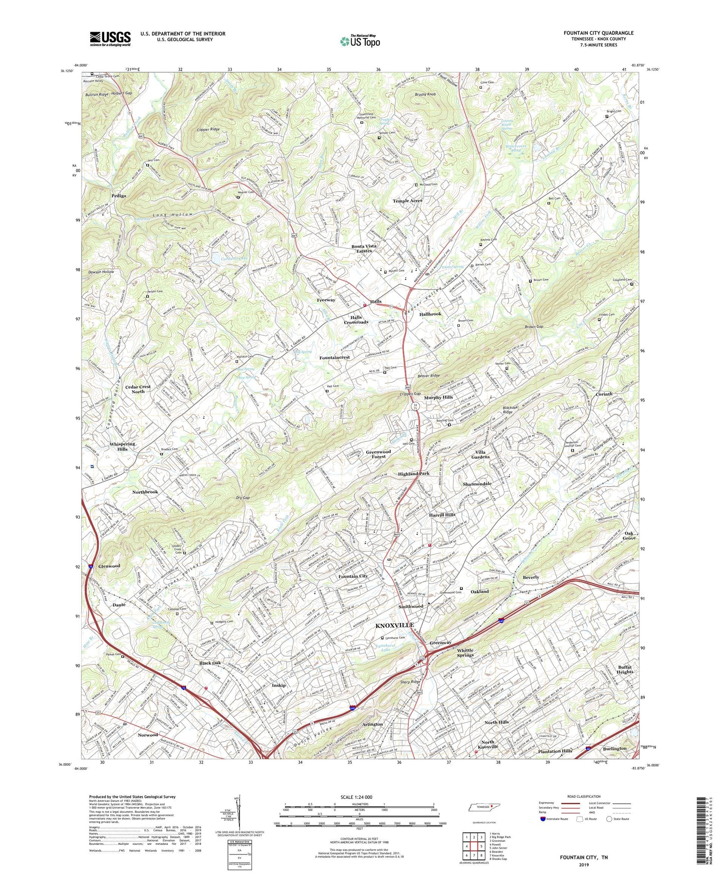
2019 topographic map quadrangle Fountain City in the state of Tennessee. Scale: 1:24000. Based on the newly updated USGS 7.5' US Topo map series, this map is in the following counties: Knox. The map contains contour data, water features, and other items you are used to seeing on USGS maps, but also has updated roads and other features. This is the next generation of topographic maps. Printed on high-quality waterproof paper with UV fade-resistant inks.
Quads adjacent to this one:
West: Powell
Northwest: Norris
North: Big Ridge Park
Northeast: Graveston
East: John Sevier
Southeast: Shooks Gap
South: Knoxville
Southwest: Bearden
Contains the following named places: Adrian Burnett Elementary School, Alice Bell Baptist Church, Alice Bell Elementary School, Allen Branch, Anderson-Gouffon Cemetery, Arlington, Arlington Baptist Church, Atkin Church, Barner Cemetery, Bayless Cemetery, Beaver Brook Country Club, Beaver Creek Church, Beaver Dale Church, Beaver Dam Church, Bell Cemetery, Belle Morris Elementary School, Beverly, Beverly Acres, Bible Presbyterian Church, Big Oak Shopping Center, Big Spring, Black Oak, Black Oak Plaza Shopping Center, Black Oaks Heights Church, Blackoak Ridge Church, Blue Spring, Blueberry Hills, Bonta Vista Estates, Bookwalter United Methodist Church, Bowling Cemetery, Bradley Cemetery, Briarwood Estates, Brickey Elementary School, Bright Cemetery, Bright Hope Methodist Church, Broadway Speedway, Broadway-Tazewell Shopping Center, Brown Cemetery, Brown Gap, Brown Gap Church, Brushy Knob, Buffat Heights, Buffat Heights Baptist Church, Callahan Cemetery, Cardwell Lake, Carter Road Church, Cedar Crest North, Cedar Flats, Cedar Grove, Cedar Grove Cemetery, Cedar Ridge Church, Cedarchase, Central Church, Central High School, Central View Church, Church of Christ, Church of the Good Shepherd, Cline Cemetery, Clinton Plaza Shopping Center, Commissioner District 2, Commissioner District 7, Community Spring, Copeland Hollow, Copper Ridge Branch, Corinth, Corinth United Methodist Church, Cornerstone Church, Coupland Cemetery, Cox Creek, Crippen Gap, Dante, Dante Dale School, Dante School, Dante United Methodist Church, Deep Spring, Dogwood Mobile Home Park, Dry Gap, Dutch Valley, Dutch Valley Baptist Church, East Tennessee Chest Disease Hospital, Embry Pike Church, Emory Estates, Emory Valley Church, Eureka Church, Fair Havens Church, Fairmont Presbyterian Church, Fieldview, Fort Sumter School, Fountain City, Fountain City Elementary School, Fountain City Park, Fountain City Post Office, Fountain City Shopping Center, Fountain Village Shopping Center, Fountaincrest, Foust Branch, Foust Hollow, Freeway, Fults Trailer Park, Golden Cross Cemetery, Granny Bright Spring, Grassy Valley, Graybell Spring, Green Hill School, Greenfield Memorial Cemetery, Greenway, Greenwood Cemetery, Greenwood Forest, Gresham Middle School, Hall Cemetery, Hallbrook, Halls, Halls And Powell Mobile Home Park, Halls Census Designated Place, Halls Central United Methodist Church, Halls Crossroads, Halls Division, Halls Elementary School, Halls High School, Halls Middle School, Halls Plaza Shopping Center, Halls Shopping Center, Halls Station Post Office, Harrill Hills, Haw Branch, Heavenly View Church, Highland Park, Highland View, Highland View Church, Hill-Top Church, Hines Branch, Hobbs Spring, Holbert Gap, Homestead, Hudgens Cemetery, Hunter Spring, Huntingdon Place, Inskip, Inskip Elementary School, Jett Cemetery, Knoxville Fire Department Fountain City Fire Station 15, Knoxville Fire Department Station 11, Knoxville Fire Department Station 14, Lammie Branch, Lincoln Park Elementary School, Long Hollow, Lynnhurst Cemetery, Lynnhurst Lake, Mapleview, Mays Chapel Methodist Church, McCampbell School, McClain Shopping Center, McCloud Cemetery, Mead Park, Merchants Village Shopping Center, Midway Shopping Center, Mill Branch, Mill Run, Mount Calvary Church, Murphy Creek, Murphy Hills, Mynatt, Mynatt Cemetery, Mynatt Road Church, Nelson Cemetery, New Beverly Church, New Hope Church, New Pleasant Gap Church, North Hills, North Knox Career and Technical Education Center, North Knoxville, Northbrook, Northgate Plaza Shopping Center, Northridge Estates, Northside Church, Norwood, Norwood Post Office, Oak Grove, Oak Park, Oakland, Oakland School, Parker Cemetery, Pedigo, Pinewood Trailer Park, Plantation Hills, Pleasant Gap, Pleasant Hill Church, Preston, Ridgeview Church, Rifle Range Estates, Robbins Memorial Church, Rural - Metro Fire Department Station 30, Saint Joseph School, Saint Paul United Methodist Church, Salem Church, Select Specialty Hospital - North Knoxville, Shannondale, Shannondale Church, Shannondale Elementary School, Sharon Church, Sharp Ridge, Sharp Ridge Memorial Park, Smithwood, Smithwood School, Spitzer Cemetery, Sterchi Elementary School, Still Brook, Temple Acres, Tillery Drive Mobile Home Park, Timber Line Estates, Tindell Cemetery, Union Church, Varner Cemetery, Villa Gardens, Wallace Cemetery, Watercress Pond, WATE-TV (Knoxville), WBIR-TV (Knoxville), WBMK-AM (Knoxville), Weaver Cemetery, WEZK-FM (Knoxville), Whispering Hills, Whites Creek, Whittle Springs, Whittle Springs Golf Club, Whittle Springs Middle School, Willow Fork, WITA-AM (Knoxville), WIVK-AM (Knoxville), WNOX-AM (Knoxville), WTVK-TV (Knoxville), ZIP Codes: 37912, 37917, 37918, 37938