MyTopo
Powell Tennessee US Topo Map
Couldn't load pickup availability
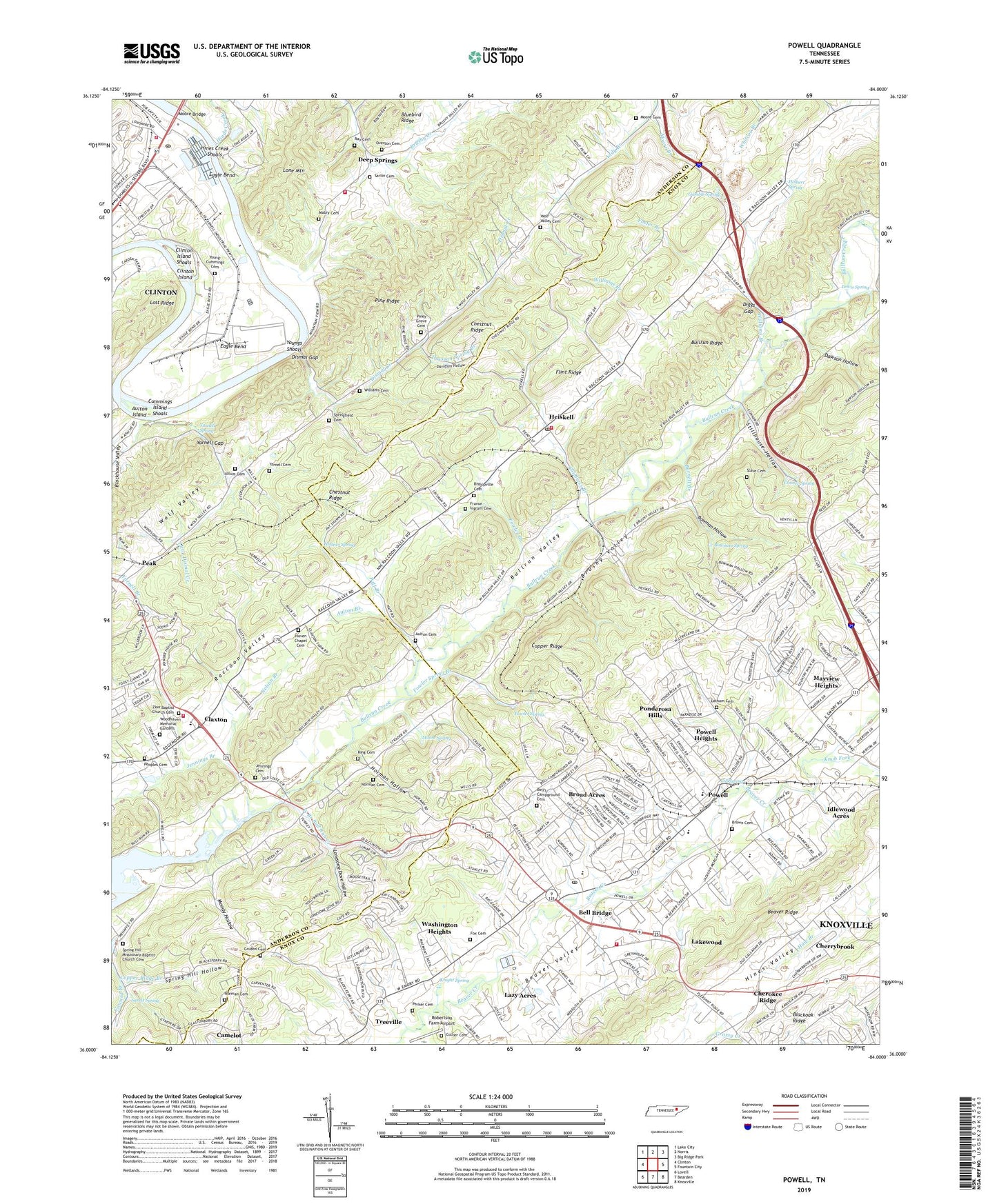
2022 topographic map quadrangle Powell in the state of Tennessee. Scale: 1:24000. Based on the newly updated USGS 7.5' US Topo map series, this map is in the following counties: Knox, Anderson. The map contains contour data, water features, and other items you are used to seeing on USGS maps, but also has updated roads and other features. This is the next generation of topographic maps. Printed on high-quality waterproof paper with UV fade-resistant inks.
Quads adjacent to this one:
West: Clinton
Northwest: Lake City
North: Norris
Northeast: Big Ridge Park
East: Fountain City
Southeast: Knoxville
South: Bearden
Southwest: Lovell
This map covers the same area as the classic USGS quad with code o36084a1.
Contains the following named places: Altum Cemetery, Andersonville Volunteer Fire Department Station 2, Aulton Branch, Aulton Cemetery, Aulton Island, Baker Mill, Beaver Creek Church, Bell Bridge, Bell Campground, Bell's Campground Cemetery, Bethel Church, Bishopville Cemetery, Bishopville Church, Blazer Branch, Bowman Hollow, Bowman Spring, Broad Acres, Brown Cemetery, Brushy Valley, Brushy Valley Church, Brushy Valley Park, Bull Run, Bullrun Ridge, Bullrun Valley, Burnett Branch, Callahan Road Church, Calvary Church, Carpenter School, Cherokee Ridge, Cherrybrook, Chestnut Ridge, Chestnut Ridge Landfill, Childress Branch, Civilian Conservation Corps Camp Number 495, Claxton, Claxton Church, Claxton Elementary School, Claxton Volunteer Fire Department, Clinton Fire Department Station 1, Clinton Forest Nursery, Clinton Island, Clinton Island Shoals, Clinton Landing Field, Clinton Post Office, Clinton South Division, Collier Cemetery, Commissioner District 1, Conner Spring, Copper Ridge Branch, Copper Ridge Church, Cumberland View Mobile Home Park, Cummings Island Shoals, Dad Mill, Davidson Hollow, Davison Spring Branch, Dawson Hollow, Deep Spring Church, Deep Springs, Diggs Gap, Dismal Creek, Dismal Gap, District 11, Dooling Chapel, Dooling Spring Branch, Eagle Bend, Eagle Bend Industrial Park, Eagle Bend Public Access Area, Eleanor Mill, Emmanuel Church, First Baptist Church of Powell, First Wesleyan Church, Flint Ridge, Foster Branch, Fowler Branch, Fowler Spring, Fowler Spring Branch, Fox Cemetery, Franse - Ingram Cemetery, Gadsden School, Gamble Spring, Gill Spring, Glenwood, Glenwood Baptist Church, Grand Oaks, Grassy Creek, Green Way Church, Grubbs Cemetery, Haven Chapel, Haven Chapel Cemetery, Haynes Spring, Heiskell, Heiskell Church, Heiskell Post Office, Heiskell School, Heiskell United Methodist Church, Hinds Creek, Hines Creek Shoals, Holbert Spring, Idlewood Acres, Jennings Branch, Jennings Cemetery, Jones Church, Jordan Siding, Karns Division, King Cemetery, Knight Spring, Knob Fork, Lakewood, Latham Cemetery, Lazy Acres, Lewis Chapel, Lewis Spring, Little Dismal Creek, Lonesome Dove Church, Lonesome Dove Hollow, Mabry Cemetery, Macedonia Church, Marine Playland Dock, Mayview Heights, Moody Hollow, Moore Branch, Moore Bridge, Moore Cemetery, Moore Ferry, Moore Spring, Moores Ford, Mount Harmony Church, Mount Hermon United Methodist Church, Mountain View School, Nelson Branch, Norman Cemetery, Norman Hollow, Northhampton Acres, Overton Cemetery, Parker Cemetery, Patt Branch, Peak, Peoples Cemetery, Piney Grove Cemetery, Piney Grove Church, Piney Grove School, Ponderosa Hills, Powell, Powell Airport, Powell Census Designated Place, Powell Division, Powell Elementary School, Powell Heights, Powell High School, Powell Middle School, Powell Park, Powell Post Office, Powell Shopping Center, Ray Cemetery, Ray Hollow, Robertson Farm Airport, Rural - Metro Fire Department Station 31, Rural / Metro Fire Department Knoxville Fleet / Training Center, Rural Metro Fire Department Knox County Station 32, Sands Spring, Sartin Cemetery, Second Baptist Church, Shadow Wood, Sites Mobile Home Park, Slave Cemetery, Spring Hill, Spring Hill Baptist Church, Spring Hill Hollow, Spring Hill Missionary Baptist Church Cemetery, Springfield Cemetery, Stillhouse Hollow, Sunnyview Church, Taylors Number 1 Quarry, Temple Baptist Academy, Temple Baptist Church, Treeville, Trinity Church, Twi-lite Zone Mobile Home Park, Union Zion Church, Washington Heights, West Branch Bull Run Creek, Whitcox Branch, Williams Branch, Williams Cemetery, Wolf Valley Baptist Church, Wolf Valley Cemetery, Woodhaven Memorial Gardens, Yarnell Cemetery, Yarnell Gap, Yarnell Spring, Young - Cummings Cemetery, Youngs Shoals, Zion Baptist Church, Zion Baptist Church Cemetery, ZIP Code: 37849