MyTopo
Gordonsville Tennessee US Topo Map
Couldn't load pickup availability
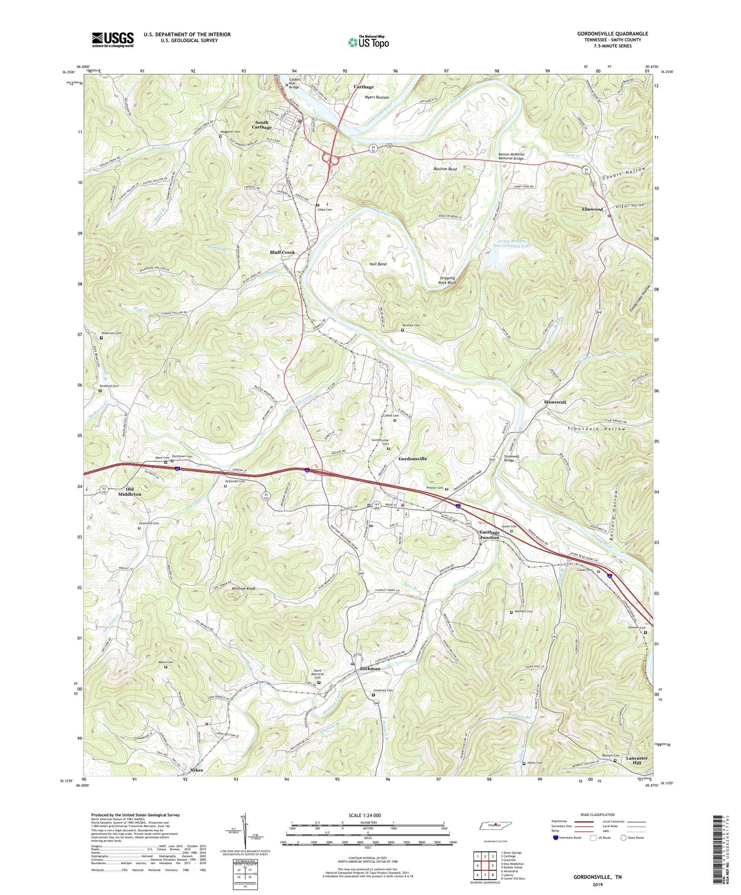
2019 topographic map quadrangle Gordonsville in the state of Tennessee. Scale: 1:24000. Based on the newly updated USGS 7.5' US Topo map series, this map is in the following counties: Smith. The map contains contour data, water features, and other items you are used to seeing on USGS maps, but also has updated roads and other features. This is the next generation of topographic maps. Printed on high-quality waterproof paper with UV fade-resistant inks.
Quads adjacent to this one:
West: New Middleton
Northwest: Dixon Springs
North: Carthage
Northeast: Granville
East: Buffalo Valley
Southeast: Center Hill Dam
South: Liberty
Southwest: Alexandria
Contains the following named places: Agee Branch, Allgier Hollow, Baird Cemetery, Baird Memorial Cemetery, Ballard Chapel, Ballard Hollow, Bennett Cemetery, Benton McMillian Memorial Bridge, Bluff Creek, Bluff Creek School, Bolling Branch, Bolling Branch Church, Bolling Branch School, Boman Branch, Boulton Bend, Bowlings Branch Church of God of Prophecy, Bradford Cemetery, Bransford Cemetery, Caney Fork, Caney Fork Church, Carthage Junction, Cedar Point Church, Coffee Cemetery, Commissioner District 5, Commissioner District 7, Condit Hollow, Coopers School, Cordell Hull Bridge, Cowan Cemetery, Cowan Hollow, Dripping Rock Bluff, Dry Fork Creek, Ducktown Cemetery, Ducktown Church, Dyer Branch, Elmwood, Elmwood Post Office, Elmwood School, Elmwood United Methodist Church, Gibbs Cemetery, Gordonsville, Gordonsville Cemetery, Gordonsville City Fire Department, Gordonsville First Baptist Church, Gordonsville High School, Gordonsville Police Department, Gordonsville Post Office, Gwaltney Cemetery, Heflin Cemetery, Hell Bend, Hickman, Hickman Baptist Church, Hickman Branch, Hickman Census Designated Place, Hickman Creek, Hickman Post Office, Hickman School, Hogan Creek Church, Hogan Creek School, James Cemetery, Jersey Miniery Zinc Company Dam, Jersey Miniery Zinc Company Lake, Lancaster Hill, Manners Cemetery, McDonald Cemetery, Moore Cemetery, Mulherrin Creek, New Middleton Elementary School, Newbell Branch, Old Middleton, Perkins Branch, Pig Branch, Preston Cemetery, Raccoon Branch, Smith County Vocational Center, Snow Creek, South Carthage, South Carthage Division, South Carthage Police Department, South Carthage Volunteer Fire Department, Stewart Cemetery, Stonewall, Stonewall Bridge, Stonewall School, Sullivan Hall Branch, Sykes Fire Department District 1, Town of Gordonsville, Town of South Carthage, Trousdale Hollow, Trousdales Ferry, Turner High School, Turney Ford Field, Union Hill Cumberland Presbyterian Church, Waggoner Cemetery, Ward Branch, Wilkerson Cemetery, Winfree Cemetery, Winfree Knob, WRKM-AM (Carthage), ZIP Code: 38567