MyTopo
Liberty Tennessee US Topo Map
Couldn't load pickup availability
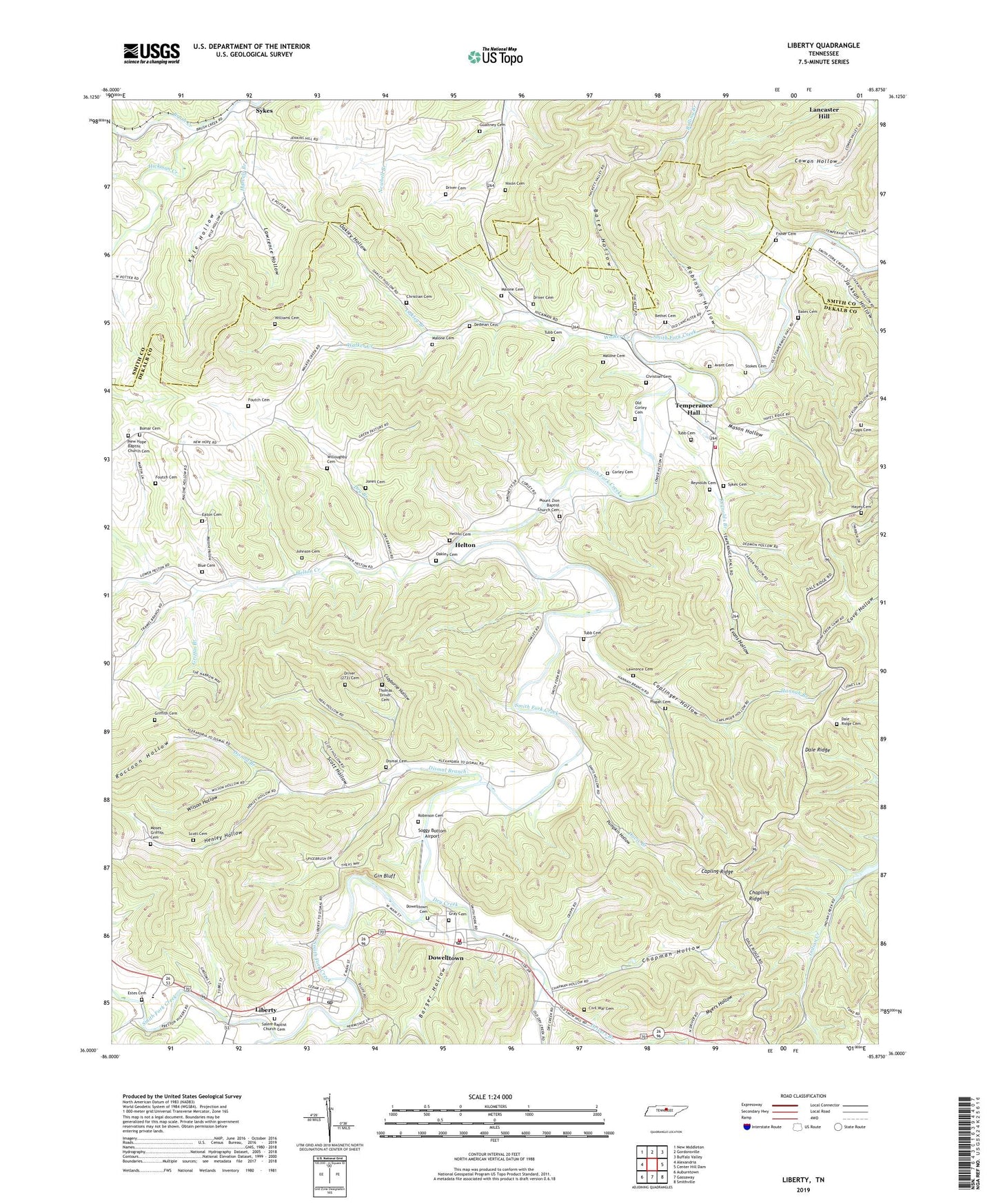
2022 topographic map quadrangle Liberty in the state of Tennessee. Scale: 1:24000. Based on the newly updated USGS 7.5' US Topo map series, this map is in the following counties: DeKalb, Smith. The map contains contour data, water features, and other items you are used to seeing on USGS maps, but also has updated roads and other features. This is the next generation of topographic maps. Printed on high-quality waterproof paper with UV fade-resistant inks.
Quads adjacent to this one:
West: Alexandria
Northwest: New Middleton
North: Gordonsville
Northeast: Buffalo Valley
East: Center Hill Dam
Southeast: Smithville
South: Gassaway
Southwest: Auburntown
This map covers the same area as the classic USGS quad with code o36085a8.
Contains the following named places: Asbury Church, Avant Cemetery, Barger Hollow, Bates Cemetery, Bates Hollow, Bethel Baptist Church, Bethel Cemetery, Blue Cemetery, Bomar Cemetery, Brush Creek, Capling Ridge, Caplinger Hollow, Cave Springs School, Chapling Ridge, Chapman Hollow, Christian Cemetery, Civil War Cemetery, Clayborne Hollow, Clear Fork Creek, Commissioner District 1, Cooper Chapel Baptist Church, Corley Cemetery, Cripps Cemetery, Dale Ridge, Dale Ridge Cemetery, Dale Ridge Missionary Baptist Church, Davis Branch, Dedman Cemetery, Dekalb County Fire Department Station 65, Dekalb County Fire Department Station 67, Dismal, Dismal Branch, Dismal Cemetery, District 11, District 12, District 15, District 17, District 19, District 2, District 20, Dowelltown, Dowelltown Baptist Church, Dowelltown Cemetery, Dowelltown Fire Department, Dowelltown Post Office, Dowelltown School, Dowelltown United Methodist Church, Driver Cemetery, Drivers Branch, Dry Branch, Dry Branch Church, Dry Creek, Eaton Cemetery, Evans Hollow, Faith Congregational Methodist Church, Fisher Cemetery, Foutch Cemetery, Fuller Chapel, Gin Bluff, Good Hope School, Gray Cemetery, Griffin Branch, Griffith Cemetery, Gualtney Cemetery, Hannah Branch, Harvels Branch, Hayes Cemetery, Helton, Helton Cemetery, Helton Creek, Helton Creek Baptist Church, Henley Hollow, Indian Creek Church, Jackson Hollow, Johnson Cemetery, Jones Cemetery, Kyle Hollow, Lancaster Hill Church, Lawrence Cemetery, Lawrence Hollow, Liberty, Liberty High School, Liberty Post Office, Lower Helton School, Malone Cemetery, Malone Hollow, Malones Chapel Missionary Baptist Church, Mason Hollow, Moses Griffith Cemetery, Mount Zion Baptist Church, Mount Zion Baptist Church Cemetery, Myers Hollow, New Hope Baptist Church, New Hope Baptist Church Cemetery, Newbell Branch School, Nixon Cemetery, Oakley Branch, Oakley Cemetery, Oakley Hollow, Old Corley Cemetery, Peaceful Pastures, Pisgah Cemetery, Pisgah Church, Pumpkin Hollow, Raccoon Hollow, Reynolds Branch, Reynolds Cemetery, Robinson Cemetery, Robinson Hollow, Salem Baptist Church, Salem Baptist Church Cemetery, Scott Cemetery, Scott Hollow, Soggy Bottom Airport, Stokes Cemetery, Sykes, Sykes Cemetery, Sykes Church of Christ, Sykes School, Temperance Hall, Temperance Hall School, Thomas Driver Cemetery, Town of Dowelltown, Town of Liberty, Tubb Cemetery, Underhill Division, Walker Creek, Walker Creek School, West Elementary School, Williams Cemetery, Willoughby Cemetery, Wilson Hollow