MyTopo
Dixon Springs Tennessee US Topo Map
Couldn't load pickup availability
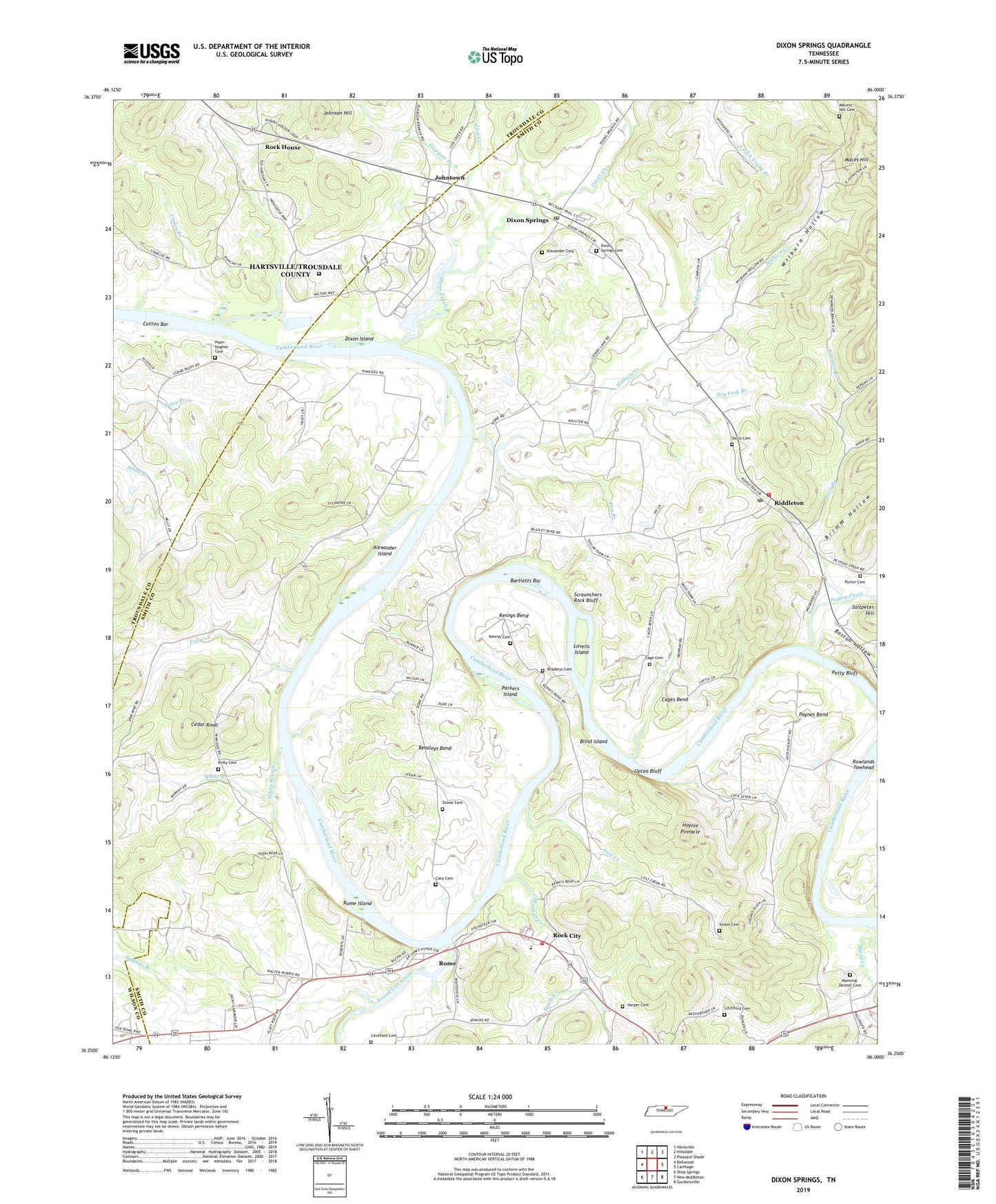
2022 topographic map quadrangle Dixon Springs in the state of Tennessee. Scale: 1:24000. Based on the newly updated USGS 7.5' US Topo map series, this map is in the following counties: Smith, Trousdale, Wilson. The map contains contour data, water features, and other items you are used to seeing on USGS maps, but also has updated roads and other features. This is the next generation of topographic maps. Printed on high-quality waterproof paper with UV fade-resistant inks.
Quads adjacent to this one:
West: Bellwood
Northwest: Hartsville
North: Hillsdale
Northeast: Pleasant Shade
East: Carthage
Southeast: Gordonsville
South: New Middleton
Southwest: Shop Springs
This map covers the same area as the classic USGS quad with code o36086c1.
Contains the following named places: Adams Chapel, Alexander Cemetery, Alexander Island, Bartletts Bar, Beasleys Bend, Blind Island, Boston Hollow, Bowman Branch, Bradleys Cemetery, Bridgewaters Landing, Brimm Hollow, Cage Cemetery, Cages Bend, Cato Cemetery, Cedar Knob, Chapel Hill Church, Commissioner District 2, Corley Branch, Cotton Bar, Cox-Davis School, Davis Branch, Davis Cemetery, Dixon Creek, Dixon Island, Dixon Springs, Dixon Springs Cemetery, Dixon Springs Post Office, Dry Branch, Dry Fork Branch, Duke Branch, Fall Creek, Glasgow Branch, Harper Cemetery, Hartsville Nuclear Power Plant, Haynie Pinnacle, Johnson Hill, Johntown, Kennys Bend, Kennys Cemetery, Kirby Cemetery, Knob Spring Church, Lick Creek, Litchford Cemetery, Lost Creek, Lovells Island, Maces Hill, Maceys Hill Cemetery, Manning-Denton Cemetery, Mount Olivet Church, New Fairview Church, Old Lock and Dam Number Seven, Parkers Island, Paynes Bend, Peyton Creek, Piper-Hughes Cemetery, Plunkett Creek, Plunketts Creek Church, Porter Cemetery, Rawls Creek, Riddleton, Riddleton Baptist Church, Riddleton Dixon Springs Volunteer Fire Department District 5, Riddleton Post Office, Rock City, Rock City / Rome Fire Department, Rock House, Rome, Rome Access Area, Rome Baptist Church, Rome Church of Christ, Rome Ferry, Rome Island, Round Lick Creek, Rowlands Towhead, Saltpeter Hill, Scraunchers Rock Bluff, Stowe Cemetery, Sulphur Branch, Taylors Branch, Union Heights Elementary School, Upton Bluff, Violet Cemetery, Ward Creek, White Branch, Whites Mill, Wilburn Creek, Wilburn Hollow, Young Branch, ZIP Code: 37151