MyTopo
Harpeth Valley Tennessee US Topo Map
Couldn't load pickup availability
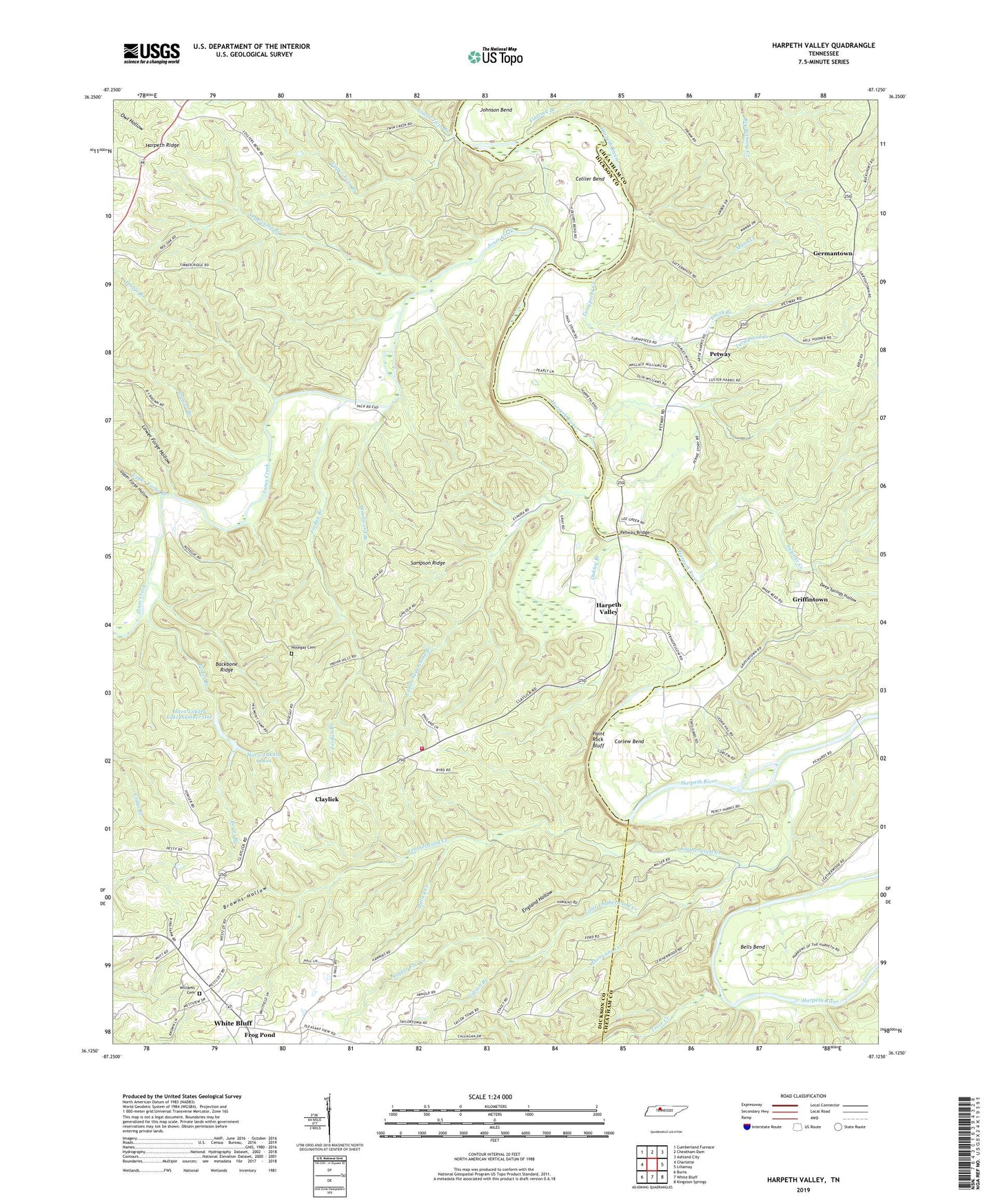
2019 topographic map quadrangle Harpeth Valley in the state of Tennessee. Scale: 1:24000. Based on the newly updated USGS 7.5' US Topo map series, this map is in the following counties: Dickson, Cheatham. The map contains contour data, water features, and other items you are used to seeing on USGS maps, but also has updated roads and other features. This is the next generation of topographic maps. Printed on high-quality waterproof paper with UV fade-resistant inks.
Quads adjacent to this one:
West: Charlotte
Northwest: Cumberland Furnace
North: Cheatham Dam
Northeast: Ashland City
East: Lillamay
Southeast: Kingston Springs
South: White Bluff
Southwest: Burns
Contains the following named places: Anderson Ford, Backbone Ridge, Bells Bend, Browns Branch, Browns Hollow, Chapel Hill Church, Claylick, Claylick Church of God of Prophecy, Claylick School, Claylick Volunteer Fire Department, Collier Bend, Collier Bend School, Commissioner District 5, Corlew Bend, Danieltown School, Dannertown, Deep Springs Hollow, England Hollow, Flatrock Branch, Frog Pond, Germantown, Gibson Branch, Griffintown, Harpeth Ridge, Harpeth Valley, Harpeth Valley Church, Harpeth Valley School, Hatley Creek, Hava Lakatu Lake Dam Number One, Hava Lakatu Lake Number One, Hava-Lakatu Lakes, Hodge Branch, Hurricane Creek, Idlewild School, Johnson Bend, Johnson Chapel, Jones Creek, Jones Creek Forge, Jones Mill, Jordan Branch, Leatherwood Creek, Little Leatherwood Creek, Lower Forge Hollow, Lower Twin Branch, Mann Creek, Midway Church, Mount Olive Church, Nosegay, Nosegay Cemetery, Oakley Branch, Paint Rock Bluff, Petway, Petway Bridge, Petway Ford, Pleasant View Church, Poplar Flat Creek, Porter Branch, Red House Forge, Sampson Ridge, Smith Branch, Stringfellow Bridge, Stringfellow School, Sugarcamp Branch, Sulphur Creek, Taylortown, Taylortown Church, Taylortown School, Trace Creek, Turnipseed Creek, Upper Forge Branch, Upper Forge Hollow, Upper Sugarcamp Branch, Upper Twin Branch, WBDX-AM (White Bluff), Williams Cemetery, Williams Chapel, Williams Chapel School, Woodward Branch, ZIP Code: 37187