MyTopo
Jeannette Tennessee US Topo Map
Couldn't load pickup availability
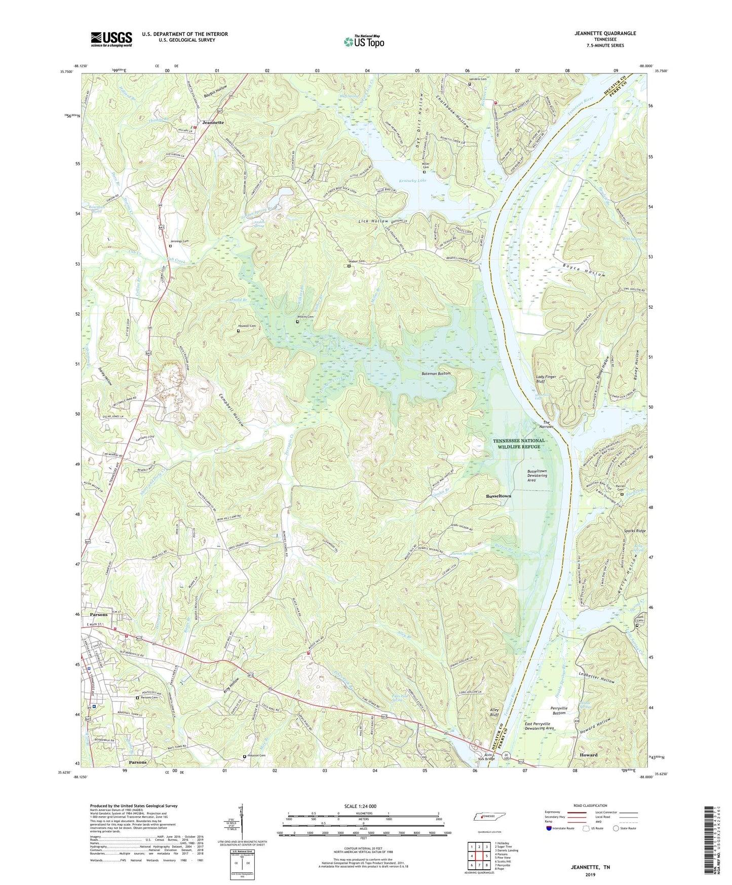
2019 topographic map quadrangle Jeannette in the state of Tennessee. Scale: 1:24000. Based on the newly updated USGS 7.5' US Topo map series, this map is in the following counties: Decatur, Perry. The map contains contour data, water features, and other items you are used to seeing on USGS maps, but also has updated roads and other features. This is the next generation of topographic maps. Printed on high-quality waterproof paper with UV fade-resistant inks.
Quads adjacent to this one:
West: Parsons
Northwest: Holladay
North: Sugar Tree
Northeast: Daniels Landing
East: Pine View
Southeast: Pope
South: Perryville
Southwest: Scotts Hill
Contains the following named places: Alley Bluff, Alley Bluff Tennessee Valley Authority Wild Area, Alley Branch, Alvin C York Bridge, Andrew Etta Landing, Arnold Branch, Bateman Bottom, Bates Branch, Belk Store, Bluff Spring, Bohannons Landing, Booty Branch, Bowman Pond, Boyce Hollow, Britt Spring, Brodies Ferry, Brodies Landing, Bunches Church, Bunches School, Burton Branch, Burton Spring, Burtons Landing, Busseltown, Busseltown Dewatering Area, Busseltown Unit Tennessee National Wildlife Refuge, Cabin Branch, Campbell Hollow, Chalkbank Hollow, Cherokee Heights, Cherokee Heights Dock, Cherry School, City of Parsons, Clifts Landing, Collins Branch, Commissioner District 5, Commissioner District 7, Commissioner District 8, Condors Landing, Cross Roads Baptist Church, Cub Creek, Dailey Hollow, Dare Branch, Decatur County General Hospital, Decatur County Rescue Squad, Decatur County Volunteer Fire Department Station 1, Decatur County Volunteer Fire Department Station 4, Decatur County Volunteer Fire Department Station 9, Denson Island, Double Springs, Double Springs Branch, Dye Dirt Hollow, East Perryville Dewatering Area, First United Pentecostal Church, Goodin Branch, Guin Branch, Hendrix Cemetery, Hewlett Branch, Hilliard Branch, Hopewell, Hopewell Baptist Church, Hopewell School, Horny Head Creek, Horseshoe Ford, Houston Cemetery, Houston Ford, Howard, Howard Church, Howard Hollow, Howesville Negro Church, Hunt Cemetery, Jeannette, Jennings Cemetery, Jordan Spring, Jordan Spring Branch, Kelly Hollow, Kelly Spring, King Hollow, Lady Finger Bluff, Ledbetter Hollow, Lick Creek, Lick Creek Landing, Lick Hollow, Little Spring Creek, Longs Store, Miller Branch, Miller Cemetery, Moore Chapel, Mount Joy School, Mountain Oak Church, Mountain Oak School, Mousetail, Mousetail Eddy, Mousetail Landing, Mousetail Landing State Park, North Fork Lick Creek, Parker Post Office, Parkers Landing, Parrish Branch, Parrish Cemetery, Parsons Cemetery, Parsons Division, Parsons Police Department, Perryville Bottom, Perryville Marina, Petty Branch, Pikes Peak Spring, Rains Branch, Raney Hollow, Ricketts Creek, Rocky Hill School, Salem Baptist Church, Sardis Ridge Baptist Church, Short and Dirty Creek, Spring Creek, Standing Rock, Standing Rock School, Storms Creek, Sulphur Fork Cub Creek, Swafford Branch, Tanner Hollow, Tennessee Division of Forestry Parsons Fire District, Terrapin Creek, The Narrows, Thomas Branch, Walker Branch, Walker Cemetery, West Mousetail Landing, Wilkins Branch, Wilkins Cemetery, ZIP Code: 38363